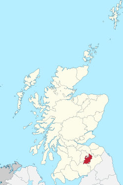
Selkirkshire
Selkirk | |
|---|---|
 | |
| Country | Scotland |
| County town | Selkirk |
| Area | |
| • Total | 267 sq mi (692 km2) |
| Ranked 27th of 34 | |
| Chapman code | SEL |
Selkirkshire or the County of Selkirk (Scottish Gaelic: Siorrachd Shalcraig) is a historic county and registration county of Scotland. It borders Peeblesshire to the west, Midlothian to the north, Roxburghshire to the east, and Dumfriesshire to the south. It derives its name from its county town, the Royal burgh of Selkirk.
Unlike many historic counties, Selkirkshire does not have its own lieutenancy area, but shares one with Roxburghshire: the Roxburgh, Ettrick and Lauderdale lieutenancy area.
History[]
In the 1st Century AD Selkirk formed part of the lands of the native people who hunted it rather than settled there. Neither the Romans, Angles, or the Saxons cleared much of the forestry there and for centuries Selkirk was known for its forest coverage. Indeed, an alternative name for the county was Ettrick Forest. Under the Scottish kings the forest was regarded as Royal. Despite this it was not until the reign of James V that sheriffs were appointed to administer the county on the Crown's behalf. During the military occupation of Scotland by Edward I of England, the forest was granted to the Earl of Gloucester.

The first recorded sheriff is Andrew de Synton, appointed by William the Lion (d. 1214).[1] Synton in the parish of Ashkirk, just east of the village centre, was an enclave of Selkirkshire surrounded by Roxburghshire.[2] Later, the Earl of Pembroke assumed the hereditary sheriffdom. Under and after King Robert the Bruce, the Earls of Douglas, and later Earls of Angus administered the county. In 1501 John Murray (d. 1510), laird of Falahill, was made sheriff of Selkirkshire and on 30 Nov. 1509 he obtained a grant of the hereditary sheriffdom of Selkirkshire.[3] His descendant Sir James Murray was deprived of office in 1681 for being remiss in punishing conventicles, but at the Glorious Revolution was raised to the session bench as Lord Philiphaugh and reinstated as sheriff. His son John Murray (died 1753) was the hereditary Sheriff of Selkirk from 1708 to 1734, when he was returned unopposed as MP for Selkirkshire, having resigned his hereditary sheriffdom to one of his sons.[4] When in 1747 the heritable jurisdictions were abolished, Murray of Philiphaugh received £4,000 in compensation. The Sheriff-Deputes, previously appointed by the hereditary sheriffs, were now appointed by the crown and acted in place of the hereditary sheriffs [5] One such sheriff of Selkirkshire was Sir Walter Scott who was appointed Sheriff-Depute in 1799, an office he held until his death in 1832.[6]

Between 1890 and 1975, it was one of the thirty-three administrative counties of Scotland, with a county council formed by the Local Government (Scotland) Act 1889. Selkirk County Council was based at the Bank of Scotland Buildings in the Market Place in Selkirk.[7][8]
Under the Local Government (Scotland) Act 1973 the use of counties as local government areas was abolished across Scotland, with administration being transferred to the Ettrick and Lauderdale district of the Borders Region.
Folk ballads written of the county commemorate the Battle of Philiphaugh in 1645, the 'Dowie Dens' at Yarrow and Tibbie Shiels at St Mary's Loch.
Geography[]

Selkirkshire is a rural county, with a handful of small settlements set within hill and forest country. It forms part of the Southern Uplands geographical region. The Ettrick Water and Yarrow Water, both tributaries of the river Tweed, flow through the county. The most prominent loch is St Mary's Loch (including the Loch of the Lowes), with smaller lochs being found east of this such as , , , , , , , and . The traditional highest point (county top) of Selkirkshire prior to border changes in the 20th century was Dun Rig, with a height of 744 metres (2,441 ft) above sea level.
Ettrick Forest[]
Ettrick Forest, also known as Selkirk and Traquair Forests, is a former royal forest in the Scottish Borders area of Scotland. It is a large area of moorland, south of Peebles, that once stretched from Ayr to Selkirk.
Keepers of the Forest[]
- Simon Fraser (1299–1306)
Transport[]
The Borders Railway connects Galashiels and Tweedbank with Edinburgh. Closed for many years, this line re-opened in 2015.[9] There are also buses to Berwick-Upon-Tweed and Carlisle operated by Borders Buses.
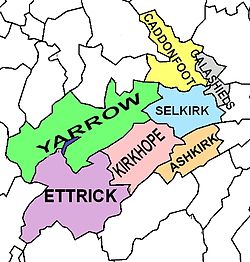
Civil parishes and population[]
Selkirkshire was historically divided into civil parishes. There were originally nine parishes; Ashkirk, Bowside, Buccleuch (or Rankilburn), Duchoire, Ettrick, Kirkhope, Lindean, St Mary's (or St Mary of the Lowes) and Selkirk. There have been a number of changes since the medieval period:
- Caddonfoot was created in 1898 from the part of the parish of Stow of Wedale that lay within Selkirkshire.
- Galashiels was formed by the union of two ancient parishes, Bowside and Lindean.
- The parish of Rankilburn or Buccleuch was suppressed and united to Yarrow c. 1600, then transferred to Ettrick 1650.[10]
- The ancient parishes of Duchoire, St Mary's and Kirkhope were united to form the parish of Yarrow; Kirkhope was then separated from Yarrow in 1852.[11]
Population of the county by Civil Parish, according to the latest census (2011):[12][13]
| Civil Parish | Area (acres) |
Pop. 2011 |
|---|---|---|
| Ashkirk | 13,159 | 246 |
| Caddonfoot | 19,252 | 912 |
| Ettrick | 42,456 | 83 |
| Galashiels | 6,487 | 10,081 |
| Kirkhope | 22,734 | 263 |
| Selkirk | 17,854 | 6,401 |
| Yarrow | 48,851 | 281 |
| COUNTY | 170,793 | 18,267 |
The population of the towns in the county (in 2011):[14]
- Galashiels - 14,994 (of which 12,893 in Selkirkshire) [15]
- Selkirk - 5,784
Historical population of the county as returned by the census was as follows:[16]
- 1801: 5,889
- 1811: 6,637
- 1821: 6,833
- 1841: 7,990
- 1851: 9,809
- 1861: 10,449
- 1871: 19,651
- 1881: 26,346
- 1891: 28,068
- 1901: 23,356
- 1911: 24,601
- 1921: 22,607
- 1931: 22,711
- 1951: 21,729
- 1961: 21,055[17]
- 1971: 20,868 [18]
- 1991: 17,456[19]
- 2001: 17,757[20]
- 2011: 18,267[12]
Settlements[]


- Boleside
- Bowhill
- Broadmeadows
- Caddonfoot
- Clovenfords
- Ettrick
- Ettrickbridge
- Galashiels (shared with Roxburghshire)
- Philiphaugh
- Roberton
- Selkirk
- Yarrow
- Yarrowford
See also[]
- James Hogg
- List of places in the Scottish Borders
- List of places in Scotland
- Craik Forest
- Wauchope Forest
- List of forests in the United Kingdom
References[]
- ^ Encyclopædia Britannica 1911 edition, article on Selkirkshire.
- ^ Ordnance Survey One-inch to the mile maps of Scotland, 1st Edition, Jedburgh, pul. 1864
- ^ Dictionary of National Biography, 1885-1900, Volume 39, by Thomas Finlayson Henderson
- ^ Web site of History of Parliament Online http://www.historyofparliamentonline.org/volume/1690-1715/constituencies/selkirkshire retrieved Feb 2016
- ^ Peebles and Selkirk. Cambridge County Geographies. By George Pringle, Cambridge, 1914. p. 119
- ^ See http://www.walterscott.lib.ed.ac.uk/biography/chronology.html retrieved Feb 2016
- ^ "No. 19011". The Edinburgh Gazette. 23 July 1971. p. 576.
- ^ Historic Environment Scotland. "Bank Of Scotland, 6 Market Place, Selkirk (LB43793)". Retrieved 18 July 2021.
- ^ Clinnick, Richard (16–29 September 2015). "The long wait is finally over as £296m Borders Railway opens". Rail. No. 783. pp. 6–7.
- ^ "Saints in Scottish Place-Names - Rankilburn, former parish, Ettrick". saintsplaces.gla.ac.uk. Retrieved 30 January 2021.
- ^ GENUKI. "Genuki: Yarrow, Selkirkshire". www.genuki.org.uk. Retrieved 30 January 2021.
- ^ a b Census of Scotland 2011, Table KS101SC – Usually Resident Population, publ. by National Records of Scotland. Web site http://www.scotlandscensus.gov.uk/ retrieved Feb 2016. See "Standard Outputs", Table KS101SC, Area type: Civil Parish 1930
- ^ Acreage from Gazetteer of Scotland, publ, by W & AK Johnston, Edinburgh, 1937. Figures for each parish, which are presented alphabetically with other places
- ^ Census of Scotland 2011, Table KS101SC – Usually Resident Population, publ. by National Records of Scotland. Web site http://www.scotlandscensus.gov.uk/ retrieved Oct 2016. See "Standard Outputs", Table KS101SC, Area type: Settlement
- ^ Excluding Tweedbank, which is in the Galashields Settlement (according to the Census map with Settlement population) but is in the civil parish of Melrose in Roxburghshire. Census of Scotland 2011, Table KS101SC – Usually Resident Population, publ. by National Records of Scotland, for Tweedbank. Web site www.scotlandscensus.gov.uk - retrieved Oct 2016. See "Standard Outputs", Table KS101SC, Area type: Output Area. (See Tweedbank Wikipedia article).
- ^ Selkirkshire: Census Tables (Vision of Britain)
- ^ Third Statistical Account of Scotland, volume Peeblesshire & Selkirkshire, publ.1964, by J.P.B. Bulloch and J.M. Urquhart; chapter on Selkirkshire: Population
- ^ Census of Scotland, 1971
- ^ Scotland's Census 1991 - National Records of Scotland - Table KS101SC - Usual resident population (aggregate of the 7 civil parishes)
- ^ Census of Scotland 2001, Table CAS002 – Population by Age by Sex and Marital Status, publ. by National Records of Scotland. Web site http://www.scotlandscensus.gov.uk/ retrieved Feb 2016. See "Standard Outputs", Table CAS002, Area type: Civil Parish 1930; total for all Selkirkshire parishes
Further reading[]
The archeology and historic buildings of the county were documented in 1957 by the Royal Commission on the Ancient and Historical Monuments in Scotland. There is also a History of Selkirkshire by T. Craig Brown, published in 1886.
External links[]
| Wikimedia Commons has media related to Selkirkshire. |
| Wikisource has the text of the 1905 New International Encyclopedia article "Selkirkshire". |
- "Selkirkshire" from A Topographical Dictionary of Scotland by Samuel Lewis, 1846 (British History Online)
- Entries on Selkirkshire from the Ordnance Gazetteer of Scotland by Frances Groome(1882-4) and the Gazetteer of the British Isles by John Bartholomew (1887) (Vision of Britain)
- EttrickForestArchers.co.uk
- RCAHMS record for Ettrick Forest or Selkirkshire
- SCRAN: Bowling champions in front of club house at Ettrick Forest Bowling Club, Selkirk
- The Borders Forest Trust
- Gazetteer for Scotland; Ettrick Forest
- Jstor: A newly discovered map of Ettrick Forest by Robert Gordon of Straloch
- The Ettrick Forest Tartan
- James Hogg, the Ettrick Shepherd

- Selkirkshire
- Former counties of Scotland
- Forests and woodlands of Scotland
- History of the Scottish Borders
- Geography of the Scottish Borders
- Counties of the United Kingdom (1801–1922)