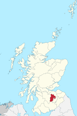
Peeblesshire
Peeblesshire | |
|---|---|
 | |
| Country | Scotland |
| County town | Peebles |
| Area | |
| • Total | 548 sq mi (1,419 km2) |
| Ranked 16th of 34 | |
| Chapman code | PEE |
Peeblesshire (Scottish Gaelic: Siorrachd nam Pùballan), the County of Peebles or Tweeddale is a historic county of Scotland. Its county town is Peebles, and it borders Midlothian to the north, Selkirkshire to the east, Dumfriesshire to the south, and Lanarkshire to the west.[1]
History[]

The Local Government (Scotland) Act 1889 established a uniform system of county councils in Scotland and realigned the boundaries of many of Scotland's counties. Subsequently, Peebles County Council was created in 1890. Peebles County Council was based at County Buildings in Rosetta Road.[2][3]
After the local government reorganisation of 1975 the county lost its administrative status, and the area was governed as the district of Tweeddale. It currently forms part of the Scottish Borders administrative area.
Coat of arms[]
The coat of arms of the county, which was matriculated by the Lord Lyon in 1931, ia as follows: Quarterly, 1st sable five fraises (strawberry leaves) argent; 2nd azure, a horse's head couped argent; 3rd vert, a fleece or; 4th or, fretty gules, on a chief embattled of the last, two thunderbolts of the first. The arms are supported by two salmon proper, and the crest is a Border cavalryman. The motto is ONWARD TWEEDDALE. The first quarter is the arms of Fraser of Oliver Castle, a prominent local laird; the second, that of Horsburgh, another prominent local laird; the third, a reference to the area's wool industry; and the fourth, that of M. G. (later Sir Michael) Thorburn of Glenormiston, who was sheriff of Peebles at the time of the arms' matriculation.[4]
Geography[]


The county is landlocked and forms part of the Southern Uplands geographic region of Scotland. There are few settlements and the county consists mostly of low hill country, including parts of the Pentland Hills and Moorfoot Hills, with the highest point being Broad Law at 840 m (2,760 ft). The river Tweed is the chief river, flowing in a crescent shape through the county. Bodies of water in Peeblesshire include the Baddinsgill Reservoir, West Water Reservoir and in the north and the Megget Reservoir, Talla Reservoir and Fruid Reservoir in the south.[citation needed]
Transport[]

The county was formerly served by the Peebles Railway and the Symington, Biggar and Broughton Railway, however these lines closed in the 1950s-60s and there are now no active railways in the county.
Settlements[]
- Blyth Bridge
- Broughton
- Cardrona
- Carlops
- Drumelzier
- Eddleston
- Innerleithen
- Kilbucho
- Kingledoors
- Lyne
- Mossfennan
- Peebles
- Polmood
- Romannobridge
- Skirling
- Stanhope
- Traquair
- Tweedsmuir
- Walkerburn
- West Linton
Civil parishes[]

- Broughton, Glenholm and Kilbucho (union of Broughton, Glenholm and Kilbucho in 1794[6])
- Drumelzier
- Eddleston
- Innerleithen
- Kirkurd
- Linton or West Linton
- Lyne (formerly Lyne and Megget; Megget, an ancient parish which was united to Lyne in 1621, was transferred to the Selkirkshire parish of Yarrow in 1891)
- Manor
- Newlands
- Peebles
- Skirling
- Stobo
- Traquair
- Tweedsmuir (separated from Drumelzier in 1643[7])
The parish of Kailzie existed until 1674, when it was suppressed, parts going to Innerleithen and parts going to Traquair.[8]
Community Councils[]
Community Councils:[9]
- Carlops
- Eddleston
- Innerleithen and District
- Lamancha, Newlands and Kirkurd
- Manor, Stobo and Lyne
- Royal Burgh of Peebles and District
- Skirling
- Tweedsmuir
- Upper Tweed
- Walkerburn
- West Linton
Gallery[]

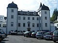
Stobo Castle

Innerleithen

Blyth Bridge

Ruins of Kilbucho Church
Barony Castle in Eddleston, which contains the Great Polish Map of Scotland

Bridge over the Tweed at Peebles, the county town

Neidpath Castle in Peebles


References[]
- ^ "Genuki - Peeblesshire".
- ^ Historic Environment Scotland. "Tweedale District Council Offices, Rosetta Road, Peebles (LB39256)". Retrieved 18 July 2021.
- ^ "Part II: 1900 - 1950 History of Peebles". p. 76. Retrieved 18 July 2021.
- ^ Urquhart, R.M. Scottish Burgh and County Heraldry. Heraldry Today. p. 232. consulted 19 December 2013.
- ^ "The Imperial gazetteer of Scotland; or, Dictionary of Scottish topography".
- ^ "Broughton". www.bordersfhs.org.uk. Retrieved 30 January 2021.
- ^ GENUKI. "Genuki: Tweedsmuir (parish), Peebles-shire". www.genuki.org.uk. Retrieved 30 January 2021.
- ^ https://www.visionofbritain.org.uk/place/22376[bare URL]
- ^ Scottish Borders Council: Scheme for the Establishment of Community Councils (under Local Government etc. (Scotland) Act 1994) www.scotborders.gov.uk/info/20015/your_council/643/community_councils retrieved June 2016
External links[]
![]() Media related to Peeblesshire at Wikimedia Commons
Media related to Peeblesshire at Wikimedia Commons
- Peeblesshire
- Former counties of Scotland
- Clan Fraser
- Tweeddale
- Defunct lieutenancy areas of Scotland
- Counties of the United Kingdom (1801–1922)