Dhaleshwari River
| Dhaleshwari River | |
|---|---|
 | |
 | |
| Location | |
| Country | Bangladesh |
| Physical characteristics | |
| Source | Jamuna River |
| Length | 160 km (99 mi) |
| Discharge | |
| • location | Shitalakshya River |
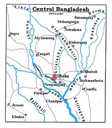
The Dhaleshwari River (Bengali: ধলেশ্বরী Dhôleshshori) is a distributary, 160 kilometres (99 mi) long, of the Jamuna River in central Bangladesh. It starts off the Jamuna near the northwestern tip of Tangail District. After that it divides into two branches: the north branch retains the name Dhaleshwari and merges with the other branch, the Kaliganga River at the southern part of Manikganj District. Finally the merged flow meets the Shitalakshya River near Narayanganj District. This combined flow goes southwards to merge into the Meghna River.
Average depth of river is 122 feet (37 m) and maximum depth is 265 feet (81 m).[1]
See also[]
- Rivers of Bangladesh
References[]
- ^ Majumdar, Dr. R.C., History of Ancient Bengal, First published 1971, Reprint 2005, pp. 3-4, Tulshi Prakashani, Kolkata.

Categories:
- Rivers of Bangladesh
- Rivers of Dhaka Division