Dinagat Island
 Location within the Philippines | |
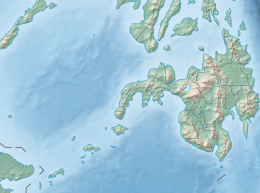 Dinagat Island Location within Mindanao | |
| Geography | |
|---|---|
| Coordinates | 10°9′46″N 125°35′22″E / 10.16278°N 125.58944°ECoordinates: 10°9′46″N 125°35′22″E / 10.16278°N 125.58944°E |
| Archipelago | Dinagat Islands |
| Adjacent bodies of water | |
| Area | 802.12 km2 (309.70 sq mi) |
| Administration | |
| Region | Caraga |
| Province | Dinagat Islands |
| Municipalities | |
| Demographics | |
| Population | 106,951 (2000) |
| Pop. density | 133.3/km2 (345.2/sq mi) |
| Ethnic groups | Visayans (Surigaonon) |


Dinagat Island is an island located northeast of Mindanao in the Philippines.
Until December 2006, it was part of the province of Surigao del Norte. Being its main island, almost all municipalities of the province of Dinagat Islands are located on it.

Nepenthes Viridis Islet, Dinagat Island
External links[]
 Geographic data related to Dinagat Island at OpenStreetMap
This article about a location in Caraga region is a stub. You can help Wikipedia by . |
Categories:
- Islands of Dinagat Islands
- Philippines geography stubs