Distomo-Arachova-Antikyra
Distomo-Arachova-Antikyra
Δίστομο-Αράχοβα-Αντίκυρα | |
|---|---|
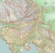 | |
 Distomo-Arachova-Antikyra Location within the region  | |
| Coordinates: 38°26′N 22°40′E / 38.433°N 22.667°ECoordinates: 38°26′N 22°40′E / 38.433°N 22.667°E | |
| Country | Greece |
| Administrative region | Central Greece |
| Regional unit | Boeotia |
| Government | |
| • Mayor | Ioannis Patsantaras (since 2011) |
| Area | |
| • Municipality | 294.05 km2 (113.53 sq mi) |
| Population (2011)[1] | |
| • Municipality | 8,188 |
| • Municipality density | 28/km2 (72/sq mi) |
| Time zone | UTC+2 (EET) |
| • Summer (DST) | UTC+3 (EEST) |
| Website | http://www.daa.gov.gr/ |

Distomo-Arachova-Antikyra (Greek: Δίστομο-Αράχοβα-Αντίκυρα) is a municipality in the Boeotia regional unit, Central Greece, Greece. The seat of the municipality is the town Distomo.[2] The municipality has an area of 294.05 km2.[3]
Municipality[]
The municipality Distomo–Arachova–Antikyra was formed at the 2011 local government reform, according to the programme Callicrates, by the merger of the following 2 former municipalities of Arachova and Distomo and from the former community Antikyra, that became municipal units:[2]
References[]
- ^ a b "Απογραφή Πληθυσμού - Κατοικιών 2011. ΜΟΝΙΜΟΣ Πληθυσμός" (in Greek). Hellenic Statistical Authority.
- ^ a b "ΦΕΚ A 87/2010, Kallikratis reform law text" (in Greek). Government Gazette.
- ^ "Population & housing census 2001 (incl. area and average elevation)" (PDF) (in Greek). National Statistical Service of Greece. Archived from the original (PDF) on 2015-09-21.
External links[]
![]() Media related to Distomo-Arachova-Antikyra at Wikimedia Commons
Media related to Distomo-Arachova-Antikyra at Wikimedia Commons
Administrative division of the Central Greece Region | ||
|---|---|---|
| Regional unit of Boeotia | 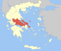 | |
| Regional unit of Euboea | ||
| Regional unit of Evrytania | ||
| Regional unit of Phocis | ||
| Regional unit of Phthiotis | ||
| ||
This Central Greece location article is a stub. You can help Wikipedia by . |
Categories:
- Municipalities of Central Greece
- Populated places in Boeotia
- Central Greece geography stubs