Division of Bass (state)
| Bass Tasmania—House of Assembly | |
|---|---|
 Map showing the Division of Bass, as of the Tasmanian state election, 2018.[1] | |
| State | Tasmania |
| Created | 1909 |
| MP | Sarah Courtney (Liberal) Michael Ferguson (Liberal) Peter Gutwein (Liberal) Jennifer Houston (Labor) Michelle O'Byrne (Labor) |
| Party | Labor (2), Liberal (3) |
| Namesake | George Bass |
| Electors | 78,182 (2021) |
| Area | 7,976 km2 (3,079.6 sq mi) |
| Demographic | Mixed |
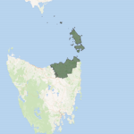
The electoral division of Bass is one of the five electorates in the Tasmanian House of Assembly, it includes north-east Tasmania and Flinders Island. Bass takes its name from the British naval surgeon and explorer of Australia: George Bass. The division shares its name and boundaries with the federal division of Bass.
Bass and the other House of Assembly electoral divisions are each represented by five members elected under the Hare-Clark electoral system.
History and electoral profile[]
Bass was created in 1909 and includes the city of Launceston and towns in the states north east including: Scottsdale, Lilydale, St Helens, George Town and others.[2]
Representation[]
Distribution of seats[]
|
| ||||||||||||||||||||||||||||||||||||||||||||||||||||||||||||||||||||||||||||||||||||||||||||||||||||||||||||||||||||||||||||||||||||||||||||||||||||||||||||||||||||||||||||||||||||||||||||||||||||||||||||||||||||||||||||||||||||||||||||||||||||||||||||||||||||||||||||||||||||||||||||||||
Members for Bass[]
See also[]
References[]
- ^ Map data: Electoral boundaries from Administrative Boundaries [May 2016] ©PSMA Australia Limited licensed by the Commonwealth of Australia under Creative Commons Attribution 4.0 International licence (CC BY 4.0).
- ^ Bass Archived 2013-04-11 at the Wayback Machine, Tasmanian Electoral Commission
External links[]
Coordinates: 41°07′48″S 147°36′58″E / 41.1300°S 147.6160°E

- Tasmanian House of Assembly electoral divisions
- North East Tasmania