Dixville, Quebec
Dixville | |
|---|---|
Municipality | |
 | |
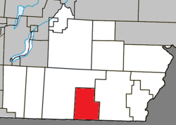 Location within Coaticook RCM | |
 Dixville Location in southern Quebec | |
| Coordinates: 45°04′N 71°46′W / 45.07°N 71.77°WCoordinates: 45°04′N 71°46′W / 45.07°N 71.77°W[1] | |
| Country | |
| Province | |
| Region | Estrie |
| RCM | Coaticook |
| Constituted | September 27, 1995 |
| Government | |
| • Mayor | Réal Ouimette |
| • Federal riding | Compton—Stanstead |
| • Prov. riding | Saint-François |
| Area | |
| • Total | 77.40 km2 (29.88 sq mi) |
| • Land | 76.64 km2 (29.59 sq mi) |
| Population | |
| • Total | 710 |
| • Density | 9.3/km2 (24/sq mi) |
| • Pop 2006-2011 | |
| • Dwellings | 291 |
| Time zone | UTC−5 (EST) |
| • Summer (DST) | UTC−4 (EDT) |
| Postal code(s) | J0B 1P0 |
| Area code(s) | 819 |
| Highways | |
| Website | www |

Dixville is a municipality in Quebec, Canada, situated east of Stanstead, in the regional county municipality of Coaticook and the region of Eastern Township.
History[]
Dixville was originally known as "Drew's Mills", named after a settler, who the early 1800s, had built a saw mill at this location on the Coaticook River. The settlement began around the year 1830; the site was back then part of the Township of Barford. A Mr. Drew set up a dwelling on the banks of the Coaticook River, cleared land to build a sawmill beside a dam which he had built. In 1836, John Wright came to join up with Drew. Soon after, others came to this place and the village became known as Drew's Mills.[4]
Shortly before the turn of the century, it was renamed Dixville, after Richard Dick Baldwin, who was known as "Uncle Dick" by the majority of the town's residents.[5]
The name Saint-Mathieu-de-Dixville was used in the past. It may be the name of the local Roman Catholic church.
Demographics[]
Population[]
Population trend:[6]
| Census | Population | Change (%) |
|---|---|---|
| 2011 | 710 | |
| 2006 | 685 | |
| 2001 | 746 | |
| 1996 | 751 | |
| 1991 | 796 | N/A |
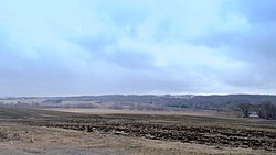
Dam[]
There is a dam in the municipality at 45° 04' 07" 71° 46' 15"
References[]
- ^ Reference number 306779 of the Commission de toponymie du Québec (in French)
- ^ Jump up to: a b Geographic code 44023 in the official Répertoire des municipalités (in French)
- ^ Jump up to: a b "(Code 2444023) Census Profile". 2011 census. Statistics Canada. 2012.
- ^ Dixville Home inc. celebrates its 50th anniversary, societehistoirecoaticook.ca
- ^ History of Dixville, societehistoirecoaticook.ca
- ^ Statistics Canada: 1996, 2001, 2006, 2011 census
External links[]
 Media related to Dixville, Quebec at Wikimedia Commons
- (in French) Official site
| show Places adjacent to Dixville, Quebec |
|---|
| show |
|---|
| Authority control |
|
|---|
This Estrie location article is a stub. You can help Wikipedia by . |
- Incorporated places in Estrie
- Municipalities in Quebec
- Coaticook Regional County Municipality
- Estrie geography stubs