Dobele Municipality
Dobele Municipality
Dobeles novads | |
|---|---|
 Flag  Coat of arms | |
 | |
| Country | |
| Formed | 2009 |
| Centre | Dobele |
| Government | |
| • Council Chair | Andrejs Spridzāns (ZZS) |
| Area | |
| • Total | 888.57 km2 (343.08 sq mi) |
| • Land | 864.55 km2 (333.80 sq mi) |
| • Water | 24.02 km2 (9.27 sq mi) |
| Population (2021)[2] | |
| • Total | 19,219 |
| • Density | 22/km2 (56/sq mi) |
| Website | www |
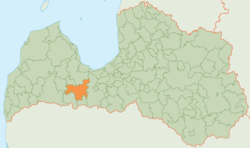
Dobele Municipality (Latvian: Dobeles novads) is a municipality in the historical region of Zemgale, and the Zemgale Planning Region in Latvia. The municipality was formed in 2009 by merging Dobele town and the Annenieki, Auri, Bērze, Biksti, Dobele, Jaunbērze, Krimūna, Naudīte, Penkule and Zebrene parishes, the administrative centre being Dobele.[3] As of 2020, the population was 19,286.[4]
Twin towns — sister cities[]
Dobele is twinned with:[5]
See also[]
References[]
- ^ https://data.stat.gov.lv/pxweb/lv/OSP_PUB/START__ENV__DR__DRT/DRT010/; Central Statistical Bureau of Latvia; retrieved: 25 February 2021.
- ^ https://data.stat.gov.lv/pxweb/lv/OSP_PUB/START__POP__IR__IRS/IRD060/; Central Statistical Bureau of Latvia; retrieved: 15 June 2021.
- ^ "Pilsēta un pagasti ; Dobeles novada pašvaldība" [Town and parishes ; Dobele Municipality self-government] (in Latvian). Dobele Municipality. Archived from the original on 2010-06-25. Retrieved 2010-09-26.
- ^ "ISG020. Population number and its change by statistical region, city, town, 21 development centres and county". Central Statistical Bureau of Latvia. 2020-01-01. Retrieved 2021-02-12.
- ^ "Sadarbības partneri". dobele.lv (in Latvian). Dobele. Retrieved 2019-08-31.
| show First-level administrative divisions of Latvia |
|---|
| show Authority control |
|---|
Coordinates: 56°39′00″N 23°14′00″E / 56.6500°N 23.2333°E

This Semigallia location article is a stub. You can help Wikipedia by . |
Categories:
- Dobele Municipality
- Municipalities of Latvia
- Zemgale geography stubs