Dobra, Łobez County
Dobra | |
|---|---|
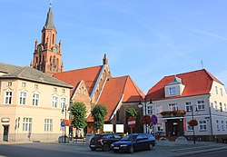 Town center with the Saint Clare church and the town hall | |
 Coat of arms | |
 Dobra | |
| Coordinates: 53°35′0″N 15°18′20″E / 53.58333°N 15.30556°E | |
| Country | |
| Voivodeship | West Pomeranian |
| County | Łobez |
| Gmina | Dobra |
| Area | |
| • Total | 2.32 km2 (0.90 sq mi) |
| Population (2006) | |
| • Total | 2,028 |
| • Density | 870/km2 (2,300/sq mi) |
| Time zone | UTC+1 (CET) |
| • Summer (DST) | UTC+2 (CEST) |
| Postal code | 72-210 |
| Area code(s) | +48 91 |
| Car plates | ZLO |
| Website | http://www.dobragmina.pl |


Dobra [ˈdɔbra] (German: Daber), also known as Dobra Nowogardzka, is a town in Łobez County, West Pomeranian Voivodeship, Poland, with 2,046 inhabitants (2004).
History[]

In the Middle Ages a Slavic gród existed in present-day Dobra.[1] In the 10th century the area became part of the emerging Polish state under Mieszko I of Poland. It was granted town rights before 1331. In the 13th and 14th centuries a castle was built, rebuilt later in the 16th century,[1] and heavily damaged in the 17th to 19th centuries. In 1647, due to the plague epidemic, the population of Dobra fell from over 600 to 48 people.[1] In 1895, a narrow-gauge railway was built, connecting the town with Stargard.[1]
Until 1945 the area was part of Germany. Following the defeat of Nazi Germany in World War II the German population was expelled and replaced by Poles.
Gallery[]
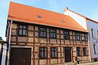
The oldest preserved townhouse in Dobra[1]
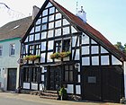
Old timber framed house

Saint Clare church
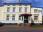
Library


References[]
- ^ Jump up to: a b c d e "Historia Dobrej, Gmina Dobra" (in Polish). Retrieved July 17, 2019.
External links[]
Coordinates: 53°35′00″N 15°18′20″E / 53.58333°N 15.30556°E
| hide | ||
|---|---|---|
| Seat |  | |
| Urban-rural gminas | ||
| Rural gmina | ||
| hide | ||
|---|---|---|
| Town and seat |  | |
| Villages | ||
This West Pomeranian Voivodeship location article is a stub. You can help Wikipedia by . |
- Cities and towns in West Pomeranian Voivodeship
- Łobez County
- West Pomeranian geography stubs