Drava Statistical Region
Drava Statistical Region
Podravska statistična regija | |
|---|---|
 | |
| Municipalities | 41 |
| Largest city | Maribor |
| Area | |
| • Total | 2,170 km2 (840 sq mi) |
| Population (2020) | |
| • Total | 325,994 |
| • Density | 150/km2 (390/sq mi) |
| Statistics | |
| • Households | 133,789 |
| • Employed | 104,446 |
| • Registered unemployed | 20,061 |
| • College/university students | 11,887 |
| • Regional GDP (2019): | EUR 6,135 bn (EUR 18,887 per capita) |
| HDI (2019) | 0.899[1] very high · 6th |
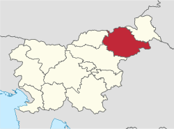
The Drava Statistical Region[2][3][4] (Slovene: Podravska statistična regija) is a statistical region in Slovenia. The largest town in the region is Maribor. Its name comes from the Drava River and includes land on both banks along its course through Slovenia as well as the Pohorje mountains in the northeast of the region. The Drava is used for the production of hydroelectricity and the fertile land around it is used for agriculture. The share of job vacancies in all available jobs is among the highest in Slovenia and the region has a positive net migration rate but a very high natural decrease, which means an overall decrease in the population.
Cities and towns[]
The Drava Statistical Region includes six cities and towns, the largest of which is Maribor.[5]
| Rank | Name | Population (2021)[6] |
|---|---|---|
1.
|
97,019
| |
2.
|
18,004
| |
3.
|
8,252
| |
4.
|
4,214
| |
5.
|
3,339
| |
6.
|
1,862
|
Administrative divisions[]
The Drava Statistical Region comprises the following 41 municipalities:
- Benedikt
- Cerkvenjak
- Cirkulane
- Destrnik
- Dornava
- Duplek
- Gorišnica
- Hajdina
- Hoče–Slivnica
- Juršinci
- Kidričevo
- Kungota
- Lenart
- Lovrenc na Pohorju
- Majšperk
- Makole
- Maribor
- Markovci
- Miklavž na Dravskem Polju
- Oplotnica
- Ormož
- Pesnica
- Podlehnik
- Poljčane
- Ptuj
- Rače–Fram
- Ruše
- Selnica ob Dravi
- Slovenska Bistrica
- Središče ob Dravi
- Starše
- Sveta Ana
- Sveta Trojica v Slovenskih Goricah
- Sveti Andraž v Slovenskih Goricah
- Sveti Jurij v Slovenskih Goricah
- Sveti Tomaž
- Šentilj
- Trnovska Vas
- Videm
- Zavrč
- Žetale
Demographics[]
The population in 2020 was 325,994. It has a total area of 2,170 km².
Economy[]
Employment structure: 63.4% services, 35.8% industry, 0.8% agriculture.
Tourism[]
It attracts only 3.2% of the total number of tourists in Slovenia, most being from foreign countries (68.9%).
Transportation[]
- Length of motorways: 132.7 km
- Length of other roads: 6,422.9 km
Sources[]
- ^ "Sub-national HDI - Area Database - Global Data Lab". hdi.globaldatalab.org. Retrieved 2021-07-20.
- ^ OECD. 2012. OECD Environmental Performance Reviews: Slovenia 2012. OECD Publishing, p. 325.
- ^ Lapuh, Lucija. 2016. Measuring the Impact of the Recession on Slovenian Statistical Regions and their Ability to Recover. Acta geographica Slovenica 56(2): 247–256, pp. 252ff.
- ^ Boršič, Darja, & Alenka Kavkler. 2009. Modeling Unemployment Duration in Slovenia Using Cox Regression Models. Transition Studies Review 54(1): 145–156, p. 148.
- ^ "Mesta in urbana območja v Sloveniji".
{{cite web}}: CS1 maint: url-status (link) - ^ "Prebivalstvo, mestna naselja, Slovenija, letno".
{{cite web}}: CS1 maint: url-status (link)
Coordinates: 46°27′00″N 15°41′00″E / 46.45000°N 15.68333°E

- Statistical regions of Slovenia