Dronne
| Dronne | |
|---|---|
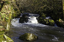 The Dronne at the rapids near Champs-Romain | |
| Location | |
| Country | France |
| Physical characteristics | |
| Source | |
| • location | Massif Central |
| • elevation | 510 m (1,670 ft) |
| Mouth | |
• location | Isle |
• coordinates | 45°2′15″N 0°8′54″W / 45.03750°N 0.14833°WCoordinates: 45°2′15″N 0°8′54″W / 45.03750°N 0.14833°W |
| Length | 201 km (125 mi) |
| Discharge | |
| • average | 25.1 m3/s (890 cu ft/s) |
| Basin features | |
| Progression | Isle→ Dordogne→ Gironde estuary→ Atlantic Ocean |

The Dronne (French pronunciation: [dʁɔn], also Drône, [dʁon]; Occitan: Drona) is a 201-kilometre (125 mi) long river in southwestern France, right tributary of the Isle.[1] Its source is in the north-western Massif Central, east of the town of Châlus (south-west of Limoges) at an elevation of 510 metres (1,670 ft). It flows south-west through the following départements and towns:
- Haute-Vienne
- Dordogne: Saint-Pardoux-la-Rivière, Brantôme, Ribérac
- Charente: Aubeterre-sur-Dronne
- Charente-Maritime
- Gironde: Coutras
The Dronne flows into the Isle in Coutras.
Among its tributaries are the Lizonne and the Côle.
References[]
External links[]
| Wikimedia Commons has media related to Dronne. |
| hide Authority control | |
|---|---|
| General |
|
| National libraries | |
This Nouvelle-Aquitaine geographical article is a stub. You can help Wikipedia by . |
Categories:
- Tributaries of the Isle
- Rivers of France
- Rivers of Dordogne
- Rivers of Gironde
- Rivers of Haute-Vienne
- Rivers of Nouvelle-Aquitaine
- Nouvelle-Aquitaine geography stubs
- France river stubs