Ducey
Ducey | |
|---|---|
Part of Ducey-les-Chéris | |
 The Sélune at Ducey | |
show Location of Ducey | |
 Ducey | |
| Coordinates: 48°37′12″N 1°17′17″W / 48.62°N 1.2881°WCoordinates: 48°37′12″N 1°17′17″W / 48.62°N 1.2881°W | |
| Country | France |
| Region | Normandy |
| Department | Manche |
| Arrondissement | Avranches |
| Canton | Pontorson |
| Commune | Ducey-les-Chéris |
| Area 1 | 11.21 km2 (4.33 sq mi) |
| Population (2017)[1] | 2,531 |
| • Density | 230/km2 (580/sq mi) |
| Demonym(s) | Ducéens |
| Time zone | UTC+01:00 (CET) |
| • Summer (DST) | UTC+02:00 (CEST) |
| Postal code | 50220 |
| Elevation | 6–113 m (20–371 ft) (avg. 15 m or 49 ft) |
| 1 French Land Register data, which excludes lakes, ponds, glaciers > 1 km2 (0.386 sq mi or 247 acres) and river estuaries. | |


Ducey is a former commune in the Manche department in north-western France. On 1 January 2016, it was merged into the new commune of Ducey-les-Chéris.[2] It is noted for its old bridge dating from 1613, which allowed pilgrims to cross the Sélune on the way to Mont Saint-Michel.[3]
Heraldry[]
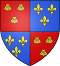 |
The arms of Ducey are blazoned : Quarterly 1&4: Gules, 3 escallops Or; 2&3: Azure, 3 fleurs de lys Or.
|
See also[]
- Communes of the Manche department
References[]
- ^ Téléchargement du fichier d'ensemble des populations légales en 2017, INSEE
- ^ Arrêté préfectoral 25 November 2015 (in French)
- ^ "Ducey History". Office de Tourisme de Ducey. Archived from the original on 6 March 2016. Retrieved 4 March 2016.
| Wikimedia Commons has media related to Ducey. |
| show Authority control |
|---|
This Manche geographical article is a stub. You can help Wikipedia by . |
Categories:
- Former communes of Manche
- Manche geography stubs