Dundee, Quebec
Dundee | |
|---|---|
Township municipality | |
 Dundee Border Inspection Station | |
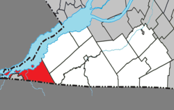 Location within Le Haut-Saint-Laurent RCM | |
 Dundee Location in southern Quebec | |
| Coordinates: 45°00′N 074°30′W / 45.000°N 74.500°WCoordinates: 45°00′N 074°30′W / 45.000°N 74.500°W[1] | |
| Country | Canada |
| Province | Quebec |
| Region | Montérégie |
| RCM | Le Haut-Saint-Laurent |
| Constituted | July 1, 1855 |
| Named for | Dundee[1] |
| Government | |
| • Mayor | Linda Gagnon |
| • Federal riding | Beauharnois—Salaberry |
| • Prov. riding | Huntingdon |
| Area | |
| • Total | 84.40 km2 (32.59 sq mi) |
| • Land | 69.45 km2 (26.81 sq mi) |
| Population (2016)[4] | |
| • Total | 387 |
| • Density | 5.6/km2 (15/sq mi) |
| • Pop 2011-2016 | |
| • Dwellings | 359 |
| Time zone | UTC−5 (EST) |
| • Summer (DST) | UTC−4 (EDT) |
| Postal code(s) | J0S 1L0 |
| Area code(s) | 450 and 579 |
| Highways | |
| Website | mrchsl |

Dundee is a township municipality in Le Haut-Saint-Laurent Regional County Municipality in the Montérégie administrative region of Quebec, Canada. At the Canada 2011 Census, the population was 408. It is primarily an agricultural area consisting of dairy and grain farms.
Geography[]
Dundee is located in the southwestern corner of the Montérégie region of Quebec. The township is bordered on the south by the Canada–United States border, on the north-west by the Saint Lawrence River, and the Mohawk reserve of Akwesasne to the west. The Salmon River runs through the municipality in a northwesterly direction from the US border to the Saint Lawrence, where many islands also make up Dundee's total area.
Communities[]
The following locations reside within the municipality's boundaries:[1]
- Dundee Centre (45°01′44″N 74°25′37″W / 45.02889°N 74.42694°W) – a hamlet in the centre of the township
- L'Île-Saint-Régis (45°01′08″N 74°38′09″W / 45.01889°N 74.63583°W) – a hamlet located on an island of the same name in the Saint Lawrence River
- Pointe-Fraser (45°02′46″N 74°27′58″W / 45.04611°N 74.46611°W) – a vacation cottage community on the Saint Lawrence River
- Pointe-Leblanc (45°04′23″N 74°26′18″W / 45.07306°N 74.43833°W) – a vacation cottage community on the Saint Lawrence River
- Sainte-Agnès-de-Dundee (45°00′34″N 74°24′04″W / 45.00944°N 74.40111°W) – a village in the southern area of the township
Lakes and rivers[]
The following waterways pass through or are situated within the municipality's boundaries:[1]
- Rivière aux Saumons (45°02′09″N 74°31′25″W / 45.03583°N 74.52361°W) – runs from the US border to the Saint Lawrence River in the municipality's western area.
Demographics[]
Population[]
| Canada census – Dundee, Quebec community profile | |||
|---|---|---|---|
| 2011 | 2006 | ||
| Population: | 408 (-6.4% from 2006) | 436 (+6.9% from 2001) | |
| Land area: | 69.76 km2 (26.93 sq mi) | 69.61 km2 (26.88 sq mi) | |
| Population density: | 5.8/km2 (15/sq mi) | 6.3/km2 (16/sq mi) | |
| Median age: | 47.5 (M: 47.6, F: 47.4) | 45.9 (M: 46.1, F: 45.5) | |
| Total private dwellings: | 336 | 327 | |
| Median household income: | $27,926 | $39,998 | |
| References: 2011[5] 2006[6] earlier[7] | |||
| Year | Pop. | ±% |
|---|---|---|
| 1991 | 382 | — |
| 1996 | 392 | +2.6% |
| 2001 | 408 | +4.1% |
| 2006 | 436 | +6.9% |
| 2011 | 408 | −6.4% |
| 2016 | 387 | −5.1% |
Language[]
| Canada Census Mother Tongue Language - Dundee, Quebec[8] | ||||||||||||||||||
|---|---|---|---|---|---|---|---|---|---|---|---|---|---|---|---|---|---|---|
| Census | Total | French
|
English
|
French & English
|
Other
| |||||||||||||
| Year | Responses | Count | Trend | Pop % | Count | Trend | Pop % | Count | Trend | Pop % | Count | Trend | Pop % | |||||
2016
|
390
|
245 | 62.82% | 115 | 29.49% | 10 | 2.56% | 15 | 3.85% | |||||||||
2011
|
410
|
255 | 62.20% | 130 | 31.70% | 10 | 2.44% | 15 | 3.66% | |||||||||
2006
|
430
|
250 | 58.14% | 155 | 36.05% | 0 | 0.00% | 25 | 5.81% | |||||||||
2001
|
415
|
200 | 48.19% | 180 | 43.37% | 10 | 2.41% | 25 | 6.02% | |||||||||
1996
|
400
|
220 | n/a | 55.00% | 135 | n/a | 33.75% | 10 | n/a | 2.50% | 35 | n/a | 8.75% | |||||
See also[]
References[]
- ^ a b c d Reference number 19755 of the Commission de toponymie du Québec (in French)
- ^ a b Ministère des Affaires municipales, des Régions et de l'Occupation du territoire: Dundee
- ^ Riding history for Beauharnois—Salaberry, Quebec from the Library of Parliament
- ^ a b 2011 Statistics Canada Census Profile: Dundee, Quebec
- ^ "2011 Community Profiles". 2011 Canadian Census. Statistics Canada. July 5, 2013. Retrieved 2014-01-27.
- ^ "2006 Community Profiles". 2006 Canadian Census. Statistics Canada. March 30, 2011. Retrieved 2013-05-10.
- ^ "2001 Community Profiles". 2001 Canadian Census. Statistics Canada. February 17, 2012.
- ^ a b Statistics Canada: 1996, 2001, 2006, 2011 census
External links[]
![]() Media related to Dundee, Quebec at Wikimedia Commons
Media related to Dundee, Quebec at Wikimedia Commons
Adjacent Municipal Subdivisions | ||||||||||||||||
|---|---|---|---|---|---|---|---|---|---|---|---|---|---|---|---|---|
| ||||||||||||||||
| Cities | |
|---|---|
| Municipalities | |
| Parishes | |
| Townships | |
| |
- Township municipalities in Quebec
- Incorporated places in Le Haut-Saint-Laurent Regional County Municipality
- Quebec populated places on the Saint Lawrence River