Dunlewey Lough
This article needs additional citations for verification. (April 2021) |
| Dunlewey Lough | |
|---|---|
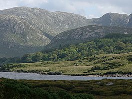 View from lake north shore | |
 Location in Ireland | |
| Location | Dunlewey, County Donegal |
| Coordinates | 55°01′22″N 8°07′56″W / 55.0227°N 8.1321°WCoordinates: 55°01′22″N 8°07′56″W / 55.0227°N 8.1321°W |
| Native name | Loch Dhún Lúiche (Irish) |
| Primary outflows | Clady River (Irish: An Chláidigh) |
| Basin countries | Ireland |
| Surface area | 14,000 acres (5,700 ha) |
| Islands | Oilean Gráinne |

Dunlewey Lough, or Dunlewy Lough (Irish: Loch Dhún Lúiche),[1] is a lake in County Donegal, Ireland. It lies at the foot of Errigal and beside the hamlet of Dunlewey (or Dunlewy). It is separated from the larger Lough Nacung Upper, to the west, by a narrow strip of land. The Cronaniv Burn, which flows through the Poisoned Glen, flows into the Devlin River very near where that river flows into Dunlewey Lough. The Devlin River flows into the south-eastern end of the lough, on the southern edge of Dunlewey village.[2]
There are the remains of a crannóg (a fortified lake dwelling) on the lake. This may be the source of the name Dún Lúiche, which means "Lugh's fort". There is a modern wooden sculpture of Lugh, an ancient Irish god, on the lakeshore.[citation needed]
On the lakeshore there is also tourist centre, called the Lakeside Centre or Ionad Cois Locha, which offers boat trips of the lake, and where they tell folk tales of a witch that is said to have lived in the big house in the forest across the lake.[citation needed]
See also[]
- List of loughs in Ireland
- Poisoned Glen
References[]
- ^ "Loch Dhún Lúiche/Dunlewy Lough". Placenames Database of Ireland (logainm.ie). Government of Ireland - Department of Arts, Heritage and the Gaeltacht and Dublin City University. Retrieved 4 February 2020.
- ^ Discovery Series Sheet 1 (Fourth Edition). Ordnance Survey of Ireland (O.S.I.), Dublin, 2012.
This article related to the geography of County Donegal, Ireland is a stub. You can help Wikipedia by . |
- Geography of Gweedore
- Lakes of County Donegal
- Gaeltacht places in County Donegal
- County Donegal geography stubs