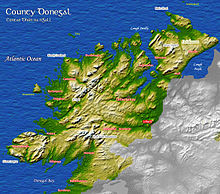
County Donegal
County Donegal
Tyrconnell Contae Dhún na nGall / Contae Thír Chonaill Coontie Dunnygal / Coontie Dinnygal | |
|---|---|
 Coat of arms | |
| Nickname(s): The O'Donnell County, The Forgotten County | |
| Motto(s): Mutuam habeatis caritatem (Latin) "Have love for one another" | |
 Location in Ireland, indicated in darker green | |
| Coordinates: 54°55′01″N 8°00′00″W / 54.917°N 8.000°WCoordinates: 54°55′01″N 8°00′00″W / 54.917°N 8.000°W | |
| Country | Ireland |
| Province | Ulster |
| Dáil Éireann | Donegal |
| EU Parliament | Midlands–North-West |
| Established | 1585[1] |
| County town | Lifford |
| Government | |
| • Type | County Council |
| Area | |
| • Total | 4,860 km2 (1,880 sq mi) |
| Area rank | 4th |
| Highest elevation (Errigal) | 751 m (2,464 ft) |
| Population (2016)[3] | 159,192 |
| • Rank | 13th |
| • Density | 32.6/km2 (84/sq mi) |
| Time zone | UTC±0 (WET) |
| • Summer (DST) | UTC+1 (IST) |
| Eircode routing keys | F92, F93, F94 |
| Telephone area codes | 074 (primarily) |
| Vehicle index mark code | DL |
| Website | www |
| Coontie Dunnygal[4][5] and Coontie Dinnygal[6] are Ulster Scots spellings. | |

County Donegal (/ˌdʌnɪˈɡɔːl, ˌdɒn-/ DUN-ig-AWL, DON-; Irish: Contae Dhún na nGall)[7] is a county of Ireland in the province of Ulster. It is named after the town of Donegal (Dún na nGall, meaning 'fort of the foreigners'[8]) in the south of the county. It has also been known as County Tyrconnell (Tír Chonaill, meaning 'Land of Conall'), after the historic territory of the same name, on which it was based. Donegal County Council is the local council and Lifford the county town.
The population was 159,192 at the 2016 census.[3]
History[]


At various times in its history, it has been known as County Tirconaill, County Tirconnell or County Tyrconnell (Irish: Tír Chonaill). The former was used as its official name during 1922–1927.[9] This is in reference to both the old túath of Tír Chonaill and the earldom that succeeded it.
County Donegal was the home of the once-mighty Clann Dálaigh, whose best-known branch was the Clann Ó Domhnaill, better known in English as the O'Donnell dynasty. Until around 1600, the O'Donnells were one of Ireland's richest and most powerful native Irish ruling families. Within Ulster, only the Uí Néill (known in English as the O'Neill Clan) of modern County Tyrone was more powerful. The O'Donnells were Ulster's second most powerful clan or ruling-family from the early 13th century through to the start of the 17th century. For several centuries the O'Donnells ruled Tír Chonaill, a Gaelic kingdom in West Ulster that covered almost all of modern County Donegal. The head of the O'Donnell family had the titles An Ó Domhnaill (meaning The O'Donnell in English) and Rí Thír Chonaill (meaning King of Tír Chonaill in English). Based at Donegal Castle in Dún na nGall (modern Donegal), the O'Donnell Kings of Tír Chonaill were traditionally inaugurated at Doon Rock near Kilmacrennan. O'Donnell royal or chiefly power was finally ended in what was then the newly created County Donegal in September 1607, following the Flight of the Earls from near Rathmullan. The modern County Arms of Donegal (dating from the early 1970s) was influenced by the design of the old O'Donnell royal arms. The County Arms is the official coat of arms of both County Donegal and Donegal County Council.

The modern County Donegal was shired[10] by order of the English Crown in 1585. The English authorities at Dublin Castle formed the new county by amalgamating the old Kingdom of Tír Chonaill with the old Lordship of Inishowen. However, although detachments of the Royal Irish Army were stationed there, the Dublin authorities were unable to establish control over Tír Chonaill and Inishowen until after the Battle of Kinsale in 1602. Full control over the new County Donegall was only achieved after the Flight of the Earls in September 1607. It was the centre of O'Doherty's Rebellion of 1608 with the key Battle of Kilmacrennan taking place there. The county was one of those 'planted' during the Plantation of Ulster from around 1610 onwards. What became the City of Derry was officially part of County Donegal up until 1610.[11]
County Donegal was the worst affected part of Ulster during the Great Famine of the late 1840s in Ireland. Vast swathes of the county were devastated, with many areas becoming permanently depopulated. Vast numbers of County Donegal's people emigrated at this time, chiefly through Foyle Port.
The Partition of Ireland in the early 1920s had a massive direct impact on County Donegal. Partition cut the county off, economically and administratively, from Derry, which had acted for centuries as the county's main port, transport hub and financial centre. Derry, together with west Tyrone, was henceforward in a new, different jurisdiction which remained within the United Kingdom, a jurisdiction officially called Northern Ireland. Partition also meant that County Donegal was now almost entirely cut off from the rest of the jurisdiction in which it now found itself, the new dominion called the Irish Free State, which in April 1949 officially became the Republic of Ireland. Only a few miles of the county is physically connected by land to the rest of the Republic. The existence of a border cutting Donegal off from her natural hinterlands in Derry City and West Tyrone greatly exacerbated the economic difficulties of the county after partition. The county's economy is particularly susceptible, just like that of Derry City, to the currency fluctuations of the Euro against sterling.
Added to all this, in the late 20th century County Donegal was adversely affected by The Troubles in Northern Ireland. The county suffered several bombings and assassinations. In June 1987, Constable Samuel McClean, a Donegal man who was a serving member of the Royal Ulster Constabulary, was shot dead by the Provisional Irish Republican Army at his family home near . In May 1991, the prominent Sinn Féin politician Councillor Eddie Fullerton was assassinated by the PIRA's opponent, the Ulster Defence Association at his home in Buncrana. This added further to the economic and social difficulties of the county. However, the greater economic and administrative integration with Northern Ireland, following the Good Friday Agreement of April 1998 has been of benefit to the county.
It has been labelled the 'forgotten county' by its own politicians, owing to the perception that it is ignored by the Government of Ireland, even in times of crisis.[12]
Geography and subdivisions[]


Located in the northwest corner of Ireland, Donegal is the island's northernmost county. In terms of size and area, it is the largest county in Ulster and the fourth-largest county in all of Ireland. Uniquely, County Donegal shares a small border with only one other county in the Republic of Ireland – County Leitrim. The vast majority of its land border (93%) is shared with three counties of Northern Ireland: County Tyrone, County Londonderry and County Fermanagh. This geographic isolation from the rest of the Republic has led to Donegal people maintaining a distinct cultural identity[13] and has been used to market the county with the slogan "Up here it's different".[14] While Lifford is the county town, Letterkenny is by far the largest town in the county with a population of just under 20,000. Letterkenny and the nearby city of Derry form the main economic axis of the northwest of Ireland.[15] Indeed, what became the City of Derry was officially part of County Donegal up until 1610.[11]

Baronies and townlands[]
There are eight historic baronies in the county.[16] While baronies continue to be officially defined units, they ceased to have any administrative function following the Local Government Act 1898, and any changes to county boundaries after the mid-19th century are not reflected in their extent. The last boundary change of a barony in Donegal was in 1851, when the barony of Inishowen was divided into Inishowen East and Inishowen West. The barony of Kilmacrennan covers a large portion of northwest Donegal and is the largest in the county. With an area of 312,410 acres (1,264 km2), Kilmacrennan is also the largest barony in Ireland, being roughly equal in size to County Monaghan. The smallest barony is Inishowen West, at 77,149 acres (312 km2).
| Barony | Irish Name | Area[17] (Acres) |
|---|---|---|
| Banagh | Báinigh | 179,090 |
| Boylagh | Baollaigh | 157,429 |
| Inishowen East | Inis Eoghain Thoir | 124,325 |
| Inishowen West | Inis Eoghain Thiar | 77,149 |
| Kilmacrennan | Cill Mhic Réanáin | 312,410 |
| Raphoe North | Ráth Bhoth Thuaidh | 80,388 |
| Raphoe South | Ráth Bhoth Theas | 141,308 |
| Tirhugh | Tír Aodha | 128,602 |
Townlands are the smallest officially defined geographical divisions in Ireland. There are 2,787 townlands in Donegal, and an additional 47 historic town boundaries. These town boundaries are registered as their own townlands and are much larger than rural townlands. The smallest rural townlands in Donegal are just 1 acre in size, most of which are either lough islands or offshore islets (Corragh Island, Bishop's Island, Juniper Island, O'Donnell's Island, etc). The largest rural townland in Donegal is 6,053 acres (Tawnawully Mountains). The average size of a townland in the county (excluding towns) is 438 acres.
Informal districts[]

The county may be informally divided into a number of traditional districts. There are two Gaeltacht districts in the west: The Rosses (Irish: Na Rosa), centred on the town of Dungloe (Irish: An Clochán Liath), and Gweedore (Irish: Gaoth Dobhair). Another Gaeltacht district is located in the north-west: Cloughaneely (Irish: Cloich Chionnaola), centred on the town of Falcarragh (Irish: An Fál Carrach). The most northerly part of the island of Ireland is the location for three peninsulas: Inishowen, Fanad and Rosguill. The main population centre of Inishowen, Ireland's largest peninsula, is Buncrana. In the east of the county lies the Finn Valley (centred on Ballybofey) and The Laggan district (not to be confused with the Lagan Valley in the south of County Antrim), which is centred on the town of Raphoe.
Physical geography[]


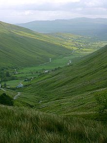

The county is the most mountainous in Ulster consisting chiefly of two ranges of low mountains; the Derryveagh Mountains in the north and the Blue Stack Mountains in the south, with Errigal at 751 metres (2,464 ft) the highest peak, making it the 11th-highest county top in Ireland. It has a deeply indented coastline forming natural sea loughs, of which both Lough Swilly and Lough Foyle are the most notable. Donegal boasts the longest mainland coastline of any county in Ireland, and has either the longest or third longest total coastline (including islands), depending on measurement. Length estimates of the Donegal coastline range from less than 1,000 kilometres (621 mi) to 1,235 kilometres (767 mi).[18] The official figure used by Donegal County Council is 1,134 km (705 mi).[19] The Slieve League cliffs are among the highest sea cliffs in Europe, while Malin Head is the most northerly point on the island of Ireland.
Two permanently inhabited islands, Arranmore and Tory Island, lie off the coast, along with a large number of islands with only transient inhabitants. The 129 km long River Erne, Ireland's ninth-longest river, enters Donegal Bay near the town of Ballyshannon. The River Erne, along with other Donegal waterways, has been dammed to produce hydroelectric power. A canal linking the Erne to the River Shannon was constructed between 1846 and 1860, creating Ireland's longest navigable waterway. The project was plagued with setbacks and closed in 1870, just ten years after its completion. A joint effort between the Irish and Northern Irish governments restored the canal in the late 20th century, and the Shannon–Erne Waterway reopened in 1994.[20]
Historically, the boundary between the kingdoms of Tír Chonaill and Tír Eoghain was demarcated by the River Foyle. However, in the 17th century an area of land west of the Foyle was given over to the newly established city of Derry, although the Foyle still demarcates a large section of Donegal's eastern boundary. To the south, the Drowes River forms a 9 km (6 mile) long natural boundary with County Leitrim.
Donegal has a population density of 32.6 people per square kilometre, the lowest in Ulster and the fifth lowest in Ireland. The county has an expansive network of wildlife and conservation zones, which includes 46 European Union designated Special Areas of Conservation (SACs) and 26 Special Protection Areas (SPAs), as well as 14 Natural Heritage Areas (NHAs), 74 proposed Natural Heritage Areas, 145 Irish Geological Heritage Areas (IGHs) and Ireland's second largest national park, Glenveagh, which extends to over 42,000 acres (170 km2) in northwestern Donegal.[21]
Owing to its scenic landscape and "world-class wilderness", Donegal was named National Geographic's "Coolest place on the Planet" in 2017.[22]
Forested area in the county extends to 55,534 ha (137,228 acres), the 4th highest total forest cover in Ireland.[23] Historic deforestation left Donegal devoid of forest cover by 1900. Much of the county's forests are commercial timber plantations which were initially established in the 1930s as a way to create rural employment in areas with poor agricultural land and high rates of emigration.[24] The county contains extensive tracts of blanket bog which are concentrated in western and upland regions. Blanket bog covers an area of 148,656 ha (367,337 acres), or roughly 30 percent of the entire county.[25]
Flora and fauna[]

Donegal has a wide variety of habitats, and over half of Ireland's plant and animal species can be found within the county. Approximately 11.4 percent of the county is covered in forest, which is about average nationally. Forest cover is not evenly spread across the county and some areas, such as Pettigo and around Lough Derg, are very heavily forested, while more exposed coastal and upland areas are virtually barren. Around 65 percent of Donegal's forests are publicly owned.
- The typical native tree species found in Donegal are Scots pine, aspen poplar, birch, hazel and oak. Other common trees include Sitka spruce, mountain ash, sycamore, European larch and horse-chestnut.[26]
- Many species of terrestrial and flying mammals live in the county, including Irish hares, brown hares, red deer, sika deer, Irish bats, common pipistrelle bats, soprano pipistrelle bats, brown long-eared bats, whiskered bats, Daubenton's bats, Natterer's bats, American mink, pygmy shrews, rabbits, pine martens, stoats, badgers, red squirrels, grey squirrels, wood mice, house mice, brown rats, otters, red foxes, hedgehogs and feral goats.[27]
- Marine mammals include harbour seals, grey seals, humpback whales, killer whales, pilot whales, fin whales, minke whales, sperm whales, Cuvier's beaked whales, common dolphins, bottlenose dolphins, Atlantic white-sided dolphins, white-beaked dolphins, striped dolphins, Risso's dolphins and (very rarely) walruses.[28]
- Notable bird species include barnacle geese, corn crakes, northern lapwings (Ireland's national bird), grey herons, long-earned owls, golden eagles, barn owls, yellowhammers, storm petrels, Arctic skuas, wrens, golfinches, Atlantic puffins, razorbills, ravens, curlews and redshanks.[29]
Despite its northerly latitude and geographic isolation, Donegal also hosts two species of amphibian (common frog & smooth newt) and two reptile species (leatherback turtle & viviparous lizard).[30]
The native Irish red deer in Donegal went extinct around 1860 and were re-introduced in the 1890s. Due to interbreeding, most deer in the county are now a Sika-Red deer hybrid. The Wild Ireland wildlife park near Burnfoot showcases some of Donegal's historic animal species that were hunted to extinction, including brown bears, lynxes and gray wolves.[31] In 2001, the golden eagle was re-introduced into Glenveagh National Park and is currently Ireland's only breeding population.[32]
A survey of the macroscopic marine algae of County Donegal was published in 2003.[33] The survey was compiled using the algal records held in the herbaria of the following institutions: the Ulster Museum, Belfast; Trinity College, Dublin; NUI Galway, and the Natural History Museum, London. Records of flowering plants include Dactylorhiza purpurella (Stephenson and Stephenson) Soó.[34]
Climate[]

The majority of Donegal has a temperate oceanic climate (Köppen climate classification: Cfb), with upland areas in the Derryveagh and Blue Stack ranges classified as oceanic subpolar (Köppen climate classification: Cfc).[35] The county's climate is heavily influenced by the North Atlantic Current. Due to the topography of western Donegal, it receives orographic rainfall, where air is forced to rise on contact with its mountainous coastline and subsequently cools and condenses, forming clouds. The mountains of Donegal are among the cloudiest places in Ireland,[36] and northern Donegal is the windiest. Irish monthly record wind speeds for March, June, July, September, November and December have all been set at Malin Head. The highest wind speed ever recorded in Donegal was 181 km/h (112 mph) on 16 September 1961, during Hurricane Debbie.[37]
The Atlantic ocean has a significant cooling effect and, due to the county's long, thin shape and punctuated coastline, nowhere in Donegal is particularly far from the ocean, giving it a generally cooler climate that is more similar to western Scotland than the rest of Ireland. The average maximum temperature in July at Malin Head is just 16.8 °C (62 °F).[38] However, due to its exposed coastal location the climate at Malin Head is not representative of the majority of the county. Winds are much lighter in the county's interior and temperatures are cooler in the winter and warmer in the summer. Annual rainfall in the county ranges from around 850 mm (33 in) in the lowlands of north-eastern Donegal to over 2,000 mm (79 in) in western mountainous areas.[39] Precipitation exceeding 1 mm (0.04 in) will fall across all areas of Donegal on over 150 days per year.
While the prevailing wind direction in Ireland is south-westerly, which brings warm, moist air from the Gulf of Mexico, a low-pressure Polar front regularly passes to the northwest of the island, bringing cold and unsettled weather to the region.[40] The upland areas of Donegal will reliably receive some covering of snow every year. In lowland areas, snow - while still relatively infrequent - is more common than in the rest of Ireland. Despite its coastal location, Malin Head records an average of 20 days of snowfall per year. In contrast Valentia Island, a similarly placed coastal station in the southwest of Ireland, records just 3.[41]
Geology and terrain[]

Donegal can be divided into six main geological subdivisions.[42] Of these, the most expansive sections are the Lower Carboniferous limestones and sandstones of south Donegal, the Devonian granite of the Donegal batholith, which extends for about 75 km in a SW-NE direction from Ardara to Fanad Head, and quartzo-feldspathic Dalradian rocks from the Precambrian era, which cover much of the rest of the county. The geology of Donegal is very similar to that of County Mayo, and both counties are located within the Grampian Terrane. The oldest rocks in Ireland are a granitic gneiss found on the island of Inishtrahull, located ca. 10 km (6.2 mi) north-east of Malin Head. They are 1.78 billion years old, making them Paleoproterozoic in age.[43] The oldest rocks on mainland Donegal are a quartzo-feldspathic paragneiss found around Lough Derg, which have been dated to 1.713 billion years ago.[44]
Donegal is the most seismically active part of Ireland. The Leenan Fault is a large strike-slip fault that bisects the county from Lough Swilly to Donegal Bay, and dozens of tremors have been recorded along the fault since the late 19th century, although none have been larger than a magnitude 3 on the Richter scale.[45][46]
The county's landscape was carved out by glaciation at the end of the Pleistocene and its subsequent retreat during the early Holocene. Donegal contains one of Ireland's three glacial fjords (or fjards) at Lough Swilly, the others being Carlingford Lough and Killary Harbour.[47] Lough Swilly is the county's largest inlet and forms the western boundary of the Inishowen Peninsula. The thick ice-sheet that once covered the region carved out deep basins in the Donegal uplands and many tarns or corrie lakes developed in these depressions after the ice had melted, including Lough Maam below Slieve Snaght and Lough Feeane under Aghla More. Larger glacial lakes formed in the county's distinctive U-shaped valleys, such as Lough Beagh and Gartan Lough in Glenveagh, and Dunlewey Lough and Lough Nacung Upper in the Poisoned Glen. Valleys such as these were the last areas to retain glaciers as temperatures rose.[48]
As the ice sheet thinned, topography became the dominant force driving the direction of ice and meltwater flow.[49] Erosion by glacial meltwater carved out large channels in southern Donegal which directed water and sediment to outwash fans in Donegal Bay. The area south of Donegal town, where the River Eske flows into the bay, is an example of one of these outwash areas. Sea-levels in the area began to stabilise around 5,000 years ago, and the balance of erosion and deposition along Donegal's coastline resulted in the development of many sandy beaches and spits interspersed with jagged sea cliffs.[50]
Demographics[]
Largest towns[]
Letterkenny is by far the largest settlement in Donegal, with a population of just under 20,000. It is the largest town in the Border Region and the 23rd largest urban area in the Republic of Ireland.

Under CSO classification, an "Urban Area" is a town with a population greater than 1,500. As of the 2016 Census, Donegal is the most rural / least urbanised county in Ireland, with less than one-third of the population (27.3 percent) living in urban areas and over 70 percent in rural areas.
| City | Population |
|---|---|
| Letterkenny | 19,274
|
| Buncrana | 6,785
|
| Ballybofey/Stranorlar | 4,852
|
| Donegal Town | 2,618
|
| Carndonagh | 2,471
|
| Ballyshannon | 2,299
|
| Bundoran | 1,963
|
| Lifford | 1,626
|
| Convoy | 1,526
|
| Moville | 1,480
|
Irish language[]

The Donegal Gaeltacht (Irish-speaking area) is the second-largest in Ireland. The version of the Irish language spoken in County Donegal is Ulster Irish.
Of the Gaeltacht population of 24,744 (16% of the county's total population), 17,132 say they can speak Irish.[57] There are three Irish-speaking parishes: Gweedore, The Rosses and Cloughaneely. Other Irish-speaking areas include Gaeltacht an Láir: Glencolmcille, Fintown, Fanad and Rosguill, the islands of Arranmore, Tory Island and Inishbofin. Gweedore is the largest Irish-speaking parish, with over 5,000 inhabitants. All schools in the region use Irish as the language of instruction. One of the constituent colleges of NUI Galway, Acadamh na hOllscolaíochta Gaeilge, is based in Gweedore.[citation needed]
Government and politics[]
Local government[]
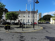

Donegal County Council (which has officially been in existence since 1899) has responsibility for local administration, and is headquartered at the County House in Lifford. Until 2014, there were also Town Councils in Letterkenny, Bundoran, Ballyshannon and Buncrana. The Town Councils were abolished in June 2014 when the Local Government Reform Act 2014 was implemented[58] and their functions were taken over by Donegal County Council. Elections to the County Council take place every five years. Thirty-seven councillors are elected using the system of proportional representation-single transferable vote (STV). For the purpose of elections the county is divided into 5 Municipal Districts comprising the following local electoral areas: Donegal (6), Glenties (6), Inishowen (9), Letterkenny (10) and Lifford–Stranorlar (6).
Council elections are held every 5 years, with the next election due to be held in May 2024. The 2019 Donegal local election had a voter turnout of 54.4%. The highest turnout was at Donegal (62.7%) and the lowest was at Lifford–Stranorlar (49.0%).[59]
| Party | Seats | FPv% | % Change since 2014 | Seat Change since 2014 | |
|---|---|---|---|---|---|
| Fianna Fáil | 12 | 29.4% | |||
| Sinn Féin | 10 | 19.4% | |||
| Fine Gael | 6 | 18.5% | |||
| Labour Party | 1 | 2.7% | |||
| Independent | 8 | 26.2% | |||
Fianna Fáil and Sinn Féin emerged as the two dominant parties in the 2019 local elections, holding 22 of the 37 seats between them. Fine Gael hold 6 seats, the Labour Party hold 1 seat and there are 8 independents. Donegal has traditionally been a stronghold for Sinn Féin, and despite their poor performance nationally in the 2019 Irish local elections, they retained their share of the vote in Donegal, dropping just 0.2%. Despite a nearly 3% increase in votes, Fine Gael did not win any additional seats in 2019.
Freedom of Donegal[]
The Freedom of Donegal is an award that is given to people who have been recognised for outstanding achievements on behalf of the people and County Donegal. Such people include Daniel O'Donnell, Phil Coulter, Shay Given, Packie Bonner, Pat Crerand, Seamus Coleman and the Brennan family. In 2009 the members of the 28th Infantry Battalion of the Irish Defence Forces were also awarded the Freedom of the County from Donegal County Council "in recognition of their longstanding service to the County of Donegal".
National elections[]
For elections to Dáil Éireann, Donegal is represented by the Donegal constituency which returns 5 TDs. The present form of the constituency was created for the 2016 general election. It encompasses the entire county, except for a small area in southern Donegal around Bundoran and Ballyshannon, which is part of the Sligo–Leitrim constituency.[60]
Historically, the county was represented in the Parliament of Ireland through the Donegal Borough constituency, which lasted from 1613 to 1800, when the Irish Parliament was abolished. Following the Act of Union, the county was represented in Westminster through the Donegal constituency until 1885. Following this, the county was broken up into four separate constituencies - North Donegal, South Donegal, East Donegal and West Donegal - which persisted until independence. The Government of Ireland Act 1920 reformed the four constituencies into a single entity covering "the administrative county of Donegal". This was broken up into Donegal East and Donegal West from 1937 to 1977, and into Donegal North-East and Donegal South-West from 1981 to 2016.
- Donegal's current representatives (2020 General Election)

Thomas Pringle,
Independent

Joe McHugh,
Fine Gael


Referendums[]
| Proposal | Donegal Result | National Result |
|---|---|---|
| 3 (1958) | 61.2% Yes | 51.8% No |
| 3 (1968) | 51.4% Yes | 60.8% No |
| 4 (1968) | 51.2% Yes | 60.8% No |
| 13 (1992) | 60.1% No | 62.4% Yes |
| 14 (1992) | 58.4% No | 59.9% Yes |
| 15 (1995) | 59.3% No | 50.3% Yes |
| 25 (2002) | 68.8% Yes | 50.4% No |
| 28 (2009) | 50.8% No | 67.1% Yes |
| 30 (2012) | 55.3% No | 60.4% Yes |
| 31 (2012) | 58.0% No | 58.0% Yes |
| 36 (2018) | 51.9% No | 66.4% Yes |
Donegal voters have a reputation nationally for being "conservative and contrarian", and have often voted against amendments to the Irish constitution which received broad support in the rest of Ireland.[61] Conversely, voters in the county have also supported several referendums which were not enacted. The trend first emerged in 1958, when voters in Donegal overwhelmingly voted to alter the electoral system from proportional representation to first-past-the-post in a referendum which was defeated nationally.
In 1968, voters in the county backed two separate bills which were also widely rejected nationwide. The first vote was to allow rural constituencies to elect a disproportionate number of TDs. Thirty-four constituencies voted against the amendment and four voted in favour, two of which were Donegal North-East and Donegal South-West. In the second vote, both Donegal constituencies again voted for the introduction of a first-past-the-post system, which was rejected.

The 23rd Amendment permitting the State to join the International Criminal Court in 2001 received the lowest support in Donegal, with just 55.8% of voters backing the proposal, compared with 64.2% nationally. Donegal is the only county to have voted against the Treaty of Lisbon twice, in 2008 and 2009.[62] Voters in the county also rejected both the Fiscal Treaty and the referendum on children's rights and state care in 2012.
On the issue of abortion and right to life vs pro-choice, Donegal has consistently been the most conservative county in Ireland. In 1992, two referendums on the issue were held. The first was an amendment which specified that the State could not limit the freedom of travel of women seeking abortions abroad. The second specified that the distribution of information about abortion services available in other countries was not unlawful. In contrast to the rest of Ireland, Donegal voted decisively against these amendments.
The twenty-fifth amendment in 2002 to tighten the ban on abortion in Ireland received the most support in Donegal. Nationally, 50.42% of voters voted against the amendment, whereas 68.8% of voters in Donegal voted in favour of it. In May 2018, Donegal was the only county in Ireland to vote against the repeal of the Eighth Amendment of the Constitution which had acknowledged the right to life of the unborn.[63] In October 2018, 48.5% of voters in Donegal voted against repealing the offence of publishing or uttering blasphemous matter, the highest of any county and significantly above the national total of 35.15%.
European elections[]
For statistical purposes at European level, the county is part of the Border Region - a NUTS III entity - which is, in turn, part of the level II NUTS entity - Northern and Western. The county is located within the Midlands–North-West constituency for elections to the European Parliament. The constituency has four seats and comprises the Border, Midlands and West regions of Ireland.
As the county is part of the Border Region, some county councillors are also representatives on the Northern and Western Regional Assembly.
Access[]

An extensive rail network used to exist throughout the county and was mainly operated by the County Donegal Railways Joint Committee and the Londonderry and Lough Swilly Railway Company (known as the L. & L.S.R. or the Lough Swilly Company for short). All these lines were laid to a 3-foot gauge, while the connecting lines were all laid to the Irish standard gauge of 1,600 mm (5 ft 3 in). This meant that all goods had to be transhipped at Derry and Strabane. Like all narrow gauge railways, this became a handicap after World War I, when road transport began to erode the railways' goods traffic.
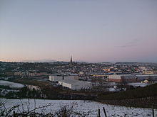
By 1953 the Lough Swilly had closed its entire railway system and become a bus and road haulage concern. The County Donegal lasted until 1960 as it had largely dieselised its passenger trains by 1951. By the late 1950s, major work was required to upgrade the track, and the Irish Government was unwilling to supply the necessary funds, so 'the Wee Donegal', as it was affectionally known, was closed in 1960. The Great Northern Railway (the G.N.R.) also ran a line from Strabane through The Laggan, a district in the east of the county, along the River Foyle into Derry. However, the railway network within County Donegal was completely closed by 1960.[64] Today, the closest railway station to the county is Waterside Station in the City of Derry, which is operated by Northern Ireland Railways (N.I.R.). Train services along the Belfast–Derry railway line run, via Coleraine railway station, to Belfast Lanyon Place and Belfast Great Victoria Street railway stations.
County Donegal is served by both Donegal Airport, located at Carrickfinn in The Rosses in the west of the county, and by City of Derry Airport, located at Eglinton to the east. The nearest main international airport to the county is Belfast International Airport (popularly known as Aldergrove Airport), which is located to the east at Aldergrove, near Antrim Town, in County Antrim, 92 km (57 mi) from Derry City and 127 km (79 mi) from Letterkenny.
Culture and Religion[]
The variant of the Irish language spoken in County Donegal shares many traits with Scottish Gaelic. The Irish spoken in the Donegal Gaeltacht (Irish-speaking area) is of the Ulster dialect, while Inishowen (parts of which only became English-speaking in the early 20th century) used the East Ulster dialect. Ulster Scots is often spoken in both the Finn Valley and The Laggan district of East Donegal. Donegal Irish has a strong influence on learnt Irish across Ulster.
Like other areas on the western seaboard of Ireland, Donegal has a distinctive fiddle tradition which is of world renown. Donegal is also well known for its songs which have, like the instrumental music, a distinctive sound. Donegal musical artists such as the bands Clannad, The Pattersons, and Altan and solo artist Enya, have had international success with traditional or traditional flavoured music. Donegal music has also influenced people not originally from the county including folk and pop singers Paul Brady and Phil Coulter. Singer Daniel O'Donnell has become a popular ambassador for the county. Popular music is also common, the county's most acclaimed rock artist being the Ballyshannon-born Rory Gallagher. Other acts to come out of Donegal include folk-rock band Goats Don't Shave, Eurovision contestant Mickey Joe Harte and indie rock group The Revs. In more recent years, bands such as in Their Thousands and Mojo Gogo have featured on the front page of Hot Press magazine.


County Donegal has a long literary tradition in both Irish and English. The Irish navvy-turned-novelist Patrick MacGill, author of many books about the experiences of Irish migrant itinerant labourers in Britain at around the start of the 20th century, such as The Rat Pit and the autobiographical Children of the Dead End, is from the Glenties area. The MacGill Summer School in Glenties is named in his honour and attracts national interest as a forum for the analysis of current affairs.[66] The novelist and socialist politician Peadar O'Donnell hailed from The Rosses in west Donegal. The poet William Allingham was also from Ballyshannon. Modern exponents include the Inishowen playwright and poet Frank McGuinness and the playwright Brian Friel. Many of Friel's plays are set in the fictional Donegal town of Ballybeg.
Authors in County Donegal have been creating works, like the Annals of the Four Masters, in Irish and Latin since the Early Middle Ages. The Irish philosopher John Toland was born in Inishowen in 1670. He was thought of as the original freethinker by George Berkeley. Toland was also instrumental in the spread of freemasonry throughout Continental Europe. In modern Irish, Donegal has produced a number of (sometimes controversial), authors such as the brothers Séamus Ó Grianna and Seosamh Mac Grianna from The Rosses and the contemporary (and controversial) Irish-language poet Cathal Ó Searcaigh from Gortahork in Cloughaneely, and where he is known to locals as Gúrú na gCnoc "Guru of the Hills".
County Donegal is known for its textiles, whose unique woollen blends are made of short threads with tiny bits of colour blended in for a heathered effect. Sometimes they are woven in a rustic herringbone format and other times in more of a box weave of varied colours. These weaves are known as donegal tweeds (with a small 'd') and are world-renowned.
There is a sizeable minority of Ulster Protestants in County Donegal, and most Donegal Protestants trace their ancestors to settlers who arrived during the Plantation of Ulster throughout the 17th century. The Church of Ireland is the largest Protestant denomination, with Presbyterianism second. The areas of County Donegal with the highest percentage of Protestants are: The Laggan district of East Donegal, centered on Raphoe;[67] the Finn Valley; and areas around Ramelton, Milford and Dunfanaghy – where their proportion reaches up to 30–45 per cent. There is also a large Protestant population between Donegal Town and Ballyshannon in the south of the county. In absolute terms, Letterkenny has the largest number of Protestants (over 1000) and is the most Presbyterian town (among those settlements with more than 3000 people) in the Republic of Ireland.[citation needed]
The Earagail Arts Festival is held within the county each July.
People from Donegal have also contributed to culture elsewhere. Francis Alison was one of the founders of the College of Philadelphia, which would later become the University of Pennsylvania.[68] Francis Makemie (originally from Ramelton) founded the Presbyterian Church in America. David Steele, from Upper Creevaugh, was a prominent Reformed Presbyterian, or Covenanter, minister who emigrated to the United States in 1824. Charles Inglis, who was the first Church of England bishop of the Diocese of Nova Scotia, was the third son of Archibald Inglis, the Rector in Glencolmcille.
Places of interest[]

The area's attractions include Glenveagh National Park (formerly part of the Glenveagh Estate), the only official national park anywhere in the Province of Ulster.[citation needed] The park is a 170 km² (about 42,000 acre) nature reserve with scenery of mountains, raised boglands, lakes and woodlands. At its heart is Glenveagh Castle, a late Victorian 'folly' that was originally built as a summer residence. Donegal was voted number one on The National Geographic Traveller (UK) 'cool list' for 2017,[69]

The Donegal Gaeltacht (Irish-speaking district) also attracts young people to County Donegal each year during the school summer holidays. The three-week-long summer Gaeltacht courses give young Irish people from other parts of the country a chance to learn the Irish language and traditional Irish cultural traditions that are still prevalent in parts of Donegal. The Donegal Gaeltacht has traditionally been a very popular destination each summer for young people from Northern Ireland.[70] Scuba diving is also very popular with a club being located in Donegal Town.
Education[]
Higher education within the county is provided by Letterkenny Institute of Technology (L.Y.I.T.; popularly known locally as 'the Regional'), established in the 1970s in Letterkenny. In addition, many young people from the county attend third-level institutions elsewhere in Ireland, especially in Derry and also at the Ulster University at Coleraine (U.U.C.), Ulster University at Jordanstown (U.U.J.), Queen's University Belfast ('Queen's'), and NUI Galway. Many Donegal students also attend the Limavady Campus of the North West Regional College (popularly known as Limavady Tech) and the Omagh College of Further Education of South West College (popularly known as Omagh Tech or Omagh College).
Sport[]
Gaelic football and hurling[]
The Gaelic Athletic Association (G.A.A.) sport of Gaelic football is very popular in County Donegal. Donegal's inter-county football team have won the All-Ireland Senior Football Championship title twice (in 1992 and 2012) and the Ulster Senior Football Championship ten times. Donegal emerged victorious from the 2012 All-Ireland Senior Football Championship Final on 23 September 2012 to take the Sam Maguire Cup for only the second time, with early goals from Michael Murphy and Colm McFadden setting up victory of 2–11 to 0–13 over Mayo. In 2007, Donegal won only their second national title by winning the National Football League. On 24 April 2011, Donegal added their third national title when they defeated Laois to capture the National Football League Division Two, they added another Division Two title in 2019. There are 16 clubs in the Donegal Senior Football Championship, with many others playing at a lower level.[71]
Hurling (often called 'hurley' within County Donegal), handball and rounders are also played but are less widespread, as in other parts of western Ulster. The Donegal county senior hurling team won the Lory Meagher Cup in 2011 and the Nicky Rackard Cup in 2013.
Rugby Union[]

There are several rugby teams in the county. These include Ulster Qualifying League Two side Letterkenny RFC, whose ground is named after Dave Gallaher, the captain of the 1905 New Zealand All Blacks touring team, who have since become known as The Originals. He was born in nearby Ramelton.
Ulster Qualifying League Three sides include Ballyshannon RFC, Donegal Town RFC and Inishowen RFC. Finn Valley RFC and Tir Chonaill RFC both compete in the Ulster Minor League North.
Association football[]
Finn Harps play in the League of Ireland and won promotion to the Premier Division in 2015 following a 2–1 aggregate win over Limerick F.C. in the playoff final. They retained their status in the Premier Division in the 2016 season. Harps' main rivals are Derry City F.C., with whom they contest Ireland's North-West Derby. Finn Harps are Donegal's only League of Ireland club, with the county's other clubs playing in either the Ulster Senior League or the local junior leagues.

Golf[]
There are a number of golf courses such as Ballyliffin Golf Club, located in the Inishowen peninsula. Other courses of note are Murvagh (located outside Donegal Town) and Rosapenna (Sandy Hills) located in Downings (near Carrigart). The Glashedy Links has been ranked 6th in a recent ranking taken by Golf Digest on the best courses in Ireland. The old links was ranked 28th, Murvagh 36th and Sandy Hills 38th.
Cricket[]
Cricket is chiefly confined to The Laggan district and the Finn Valley in the east of the county. The town of Raphoe and the nearby village of St Johnston, both in The Laggan, are the traditional strongholds of cricket within the county. The game is mainly played and followed by members of the Ulster Protestants of Co. Donegal. St Johnston Cricket Club play in the North West Senior League, while Letterkenny Cricket Club play in the Derry Midweek League.[72]
Other sports[]
Donegal's rugged landscape and coastline lends itself to active sports like climbing, mountain biking, hillwalking, surfing and kite-flying.

People[]
See also[]
- List of Donegal people
- List of monastic houses in County Donegal
- List of National Monuments in County Donegal
- List of public art in County Donegal
- List of townlands of County Donegal
- List of towns and villages in the Republic of Ireland
- List of abbeys and priories in the Republic of Ireland (County Donegal)
- People from County Donegal
- Donegal County (Parliament of Ireland constituency)
- Earagail Arts Festival
- High Sheriff of Donegal
- Lord Lieutenant of Donegal
- SS Donegal
- The Troubles
- Wild Atlantic Way
References[]
- ^ "County Donegal – Welcome To Ireland – History of Ireland".
- ^ "County Profiles – Donegal". Western Development Commission. Retrieved 2 June 2021.
- ^ Jump up to: a b c "Census 2016 Sapmap Area: County Donegal". Central Statistics Office (Ireland). Retrieved 26 October 2018.
- ^ "2006 Annual Report in Ulster Scots" (PDF). North-South Ministerial Council. Archived from the original (PDF) on 27 February 2013.
- ^ "2002 Annual Report in Ulster Scots" (PDF). North-South Ministerial Council. Archived from the original (PDF) on 29 August 2011.
- ^ Tourism Ireland – Yeirly Report 2009 Archived 30 September 2011 at the Wayback Machine
- ^ "Dún na nGall/Donegal". Placenames Database of Ireland (logainm.ie). Government of Ireland – Department of Arts, Heritage and the Gaeltacht and Dublin City University. Retrieved 7 August 2019.
- ^ "Donegal Town Website Donegal Town (Dún na nGall), Donegal". donegaltown.ie.
- ^ Renamed "County Tirconaill" 1922 by resolution of the county council.(Place Name Confusion – Donegal or Tirconaill, The Irish Times, 24 April 1924). After historians and Gaelic scholars pointed out that the historic territory of Tirconaill did not include the whole county, the name Donegal was re-adopted in 1927 (Back to "Donegal", The Irish Times, 22 November 1927).
- ^ Connolly, S.J. (2011). The Oxford Companion to Irish History. OUP Oxford. p. 129. ISBN 978-0-19-969186-9.
- ^ Jump up to: a b Brian Lacy (Editor), Archaeological Survey of County Donegal, P. 1. Donegal County Council, Lifford, 1983.
- ^ "Donegal 'wiped off crisis HQ maps'". Irish Independent. 21 April 2010. Retrieved 17 May 2021.
- ^ "Donegal Library Services". Donegallibrary.ie. Archived from the original on 20 October 2013. Retrieved 9 July 2013.
- ^ Ireland Northwest.
- ^ "Derry and Donegal Sinn Féin Councillors join forces to push North West tourism". Sinnfein.ie. 16 February 2009. Retrieved 9 July 2013.
- ^ Placenames Database of Ireland - Baronies.
- ^ "Townlands in Co. Donegal". townlands.ie.
- ^ "Managing the Donegal Coast in the Twenty-first Century" (PDF). research.thea.ie. Institute of Technology, Sligo. Retrieved 13 July 2021.
- ^ "Seascape Character Assessment of County Donegal" (PDF). donegalcoco.ie. Donegal County Council. Retrieved 13 July 2021.
- ^ Delany 2004, pp. 199–201.
- ^ "The Donegal Local Economic & Community Plan 2016-2022" (PDF). donegalcoco.ie. Donegal County Council. Retrieved 23 July 2021.
- ^ "Donegal named coolest place on planet by National Geographic". The Irish Times.
- ^ "National Forestry Inventory, Third Cycle 2017". DAFM.
- ^ O'Carroll, pp. 22-23
- ^ Douglas et al., pp. 27
- ^ "Trees & Plants - Glenveagh National Park". askaboutireland.ie. Retrieved 21 July 2021.
- ^ Donegal CoCo., pp. 89
- ^ Donegal CoCo., pp. 89
- ^ Donegal CoCo., pp. 85-88
- ^ Donegal CoCo., pp. 84
- ^ "Bears, wolves, lynx and monkeys at Donegal wildlife sanctuary". rte.ie. Retrieved 21 July 2021.
- ^ "Golden Eagle pair spotted in Glenveagh National Park". glenveaghnationalpark.ie. Retrieved 21 July 2021.
- ^ Morton, O. 2003. The marine macroalgae of County Donegal, Ireland. Bulletin of Irish biogeoghical Society. 27: 3 – 164
- ^ Ennis, T. 2014. The occurrence of Dactylorhiza purpurella (T.Stephenson and T.S.Stephenson) Soó Irish Naturalists' Journal. 33: 128
- ^ "Extreme weather records for Ireland". met.ie. Retrieved 21 July 2021.
- ^ "Climate of Ireland - Sunshine". met.ie. Retrieved 21 July 2021.
- ^ "Extreme weather records for Ireland". met.ie. Retrieved 21 July 2021.
- ^ "Malin Head 1981–2010 averages". met.ie. Retrieved 21 July 2021.
- ^ "Climate of Ireland - Rainfall". met.ie. Retrieved 21 July 2021.
- ^ "Climate of Ireland - Polar front". met.ie. Retrieved 21 July 2021.
- ^ "Valentia 1981–2010 averages". met.ie. Retrieved 21 July 2021.
- ^ GSI., pp. 29
- ^ Muir, R.J.; Fitches W.R.; Maltman A.J. (1994). "The Rhinns Complex: Proterozoic basement on Islay and Colonsay, Inner Hebrides, Scotland, and on Inishtrahull, NW Ireland". Transactions of the Royal Society of Edinburgh: Earth Sciences. 85 (1): 77–90. doi:10.1017/s0263593300006313. Retrieved 15 September 2012.
- ^ "Geology of County Donegal" (PDF). gsi.ie. Retrieved 22 July 2021.
- ^ "Why does Donegal get a disproportionate number of Irish earthquakes?". irishtimes.com. Retrieved 22 July 2021.
- ^ "Earthquake close to Irish border in County Donegal". bbc.com. Retrieved 22 July 2021.
- ^ Dundurn 2000, p. 4.
- ^ GSI., pp. 37
- ^ GSI., pp. 38
- ^ GSI., pp. 36
- ^ For 1653 and 1659 figures from Civil Survey Census of those years, Paper of Mr Hardinge to Royal Irish Academy 14 March 1865.
- ^ "Server Error 404 – CSO – Central Statistics Office". cso.ie.
- ^ "A collection of British Historical Population Reports". University of Essex. Archived from the original on 7 May 2016. Retrieved 9 July 2013.
- ^ "Census 2013". Northern Ireland Statistics and Research Agency, Government of the United Kingdom. 27 September 2010. Archived from the original on 17 February 2012. Retrieved 9 July 2013.
- ^ Lee, JJ (1981). "On the accuracy of the Pre-famine Irish censuses". In Goldstrom, J. M.; Clarkson, L. A. (eds.). Irish Population, Economy, and Society: Essays in Honour of the Late K. H. Connell. Oxford, England: Clarendon Press.
- ^ Mokyr, Joel; O Grada, Cormac (November 1984). "New Developments in Irish Population History, 1700–1850". The Economic History Review. 37 (4): 473–488. doi:10.1111/j.1468-0289.1984.tb00344.x. hdl:10197/1406. Archived from the original on 4 December 2012.
- ^ Donegal Gaeltacht statistics Archived 26 May 2013 at the Wayback Machine
- ^ http://www.irishstatutebook.ie/pdf/2014/en.act.2014.0001.pdf[bare URL]
- ^ "Donegal County Council - Local Election candidates". RTÉ. 15 May 2019. Retrieved 31 May 2021.
- ^ "Constituency Commission Report 2012 – Introduction and summary of recommendation" (PDF). Constituency Commission. 21 June 2012. Retrieved 31 May 2021.
- ^ "Even Donegal voted YES in the marriage referendum". TheJournal.ie. 23 May 2015. Retrieved 31 May 2021.
- ^ "Donegal got no Lisbon opt-out". 26 July 2016. Retrieved 31 May 2021.
- ^ "'Life is precious': Donegal quietly defiant after voting no in referendum". The Guardian. 27 May 2018. Retrieved 31 May 2021.
- ^ "Closure of the 'Derry Road' a great loss to Ireland – Derry Journal". Archived from the original on 12 December 2013. Retrieved 20 August 2013.
- ^ Jump up to: a b Willie Cumming, Duncan McLaren and T.J. O'Meara, An Introduction to the Architectural Heritage of County Donegal, p. 96. National Inventory of Architectural Heritage (N.I.A.H.), Department of Arts, Heritage, Regional, Rural and Gaeltacht Affairs, Dublin, 2014.
- ^ "About". MacGill Summer School. n.d. Archived from the original on 10 June 2019. Retrieved 21 October 2019.
- ^ Brexit and the border: Views of Donegal Protestants (BBC News, 2 January 2018). https://www.bbc.com/news/uk-northern-ireland-foyle-west-42491577.amp
- ^ Who Was Who in America, Historical Volume, 1607–1896. Chicago: Marquis Who's Who. 1963.
- ^ "The Cool List: 17 for 2017". n.d.
- ^ Hyde, Fiona. "8 things we all did in the Gaeltacht". The Daily Edge. Retrieved 26 November 2018.
- ^ "Donegal Gaelic football and hurling Clubs". clubgaa.ie. Archived from the original on 30 August 2014. Retrieved 25 July 2007.
- ^ McNulty, Chris. "Howzat! New Letterkenny Cricket Club Joins North West League". Donegal Daily. Retrieved 8 June 2019.
Further reading[]
- O'Carroll, Niall. Forestry in Ireland - A Concise History, National Council for Forest Research and Development, 2004
- Delany, Ruth (2004). Ireland's Inland Waterways. Appletree Press. ISBN 978-0-86281-824-1.
- Donegal CoCo. Biodiversity Species List for County Donegal (with priorities), An Action of the County Donegal Heritage Plan (2007-2011), Donegal County Council, 2009
- Douglas, C, O'Sullivan, A, Grogan, H, Kelly, L, Garvey, L, Van Doorslaer, L, Scally, L, Dunnells, D, & Wyse Jackson, M, Goodwillie, R, Mooney, E. Distribution, Ecology and Conservation of Blanket Bog in Ireland, National Parks and Wildlife Service, 2000
- Dundurn (2000). Inishowen: Paintings and Stories from the Land of Eoghan. Dundurn. ISBN 9781900935173.
- Geological Survey of Ireland (GSI). The Geological Heritage of Donegal: An audit of County Geological Sites in Donegal 2019, The Department of the Environment, Climate and Communications, 2019
- Seán Beattie (2004). Donegal. Sutton: Printing Press. ISBN 0-7509-3825-0.(Ireland in Old Photographs series)
- Morton, O. 2003. The marine macroalgae of County Donegal, Ireland. Bull. Ir. biogeog.soc. 27: 3–164.
- Annals of the Kingdom of Ireland (Annála Ríoghachta Éireann) by the Four Masters, from the earliest period to the year 1616, compiled during the period 1632–36 by Brother Michael O'Clery, translated and edited by John O'Donovan in 1856, and re-published in 1998 by De Burca, Dublin.
- Parks, H.M. 1958. A general survey of the marine algae of Mulroy Bay, Co. Donegal. Ir. Nat. J. 12: 277–83.
- Parks, H.M. 1958. A general survey of the marine algae of Mulroy Bay, Co. Donegal: II Ir. Nat. J. 12: 324–30.
- Patrick Buckland, A History of Northern Ireland. Gill & Macmillan, Dublin, 1981.
- John Bowman, De Valera and the Ulster Question, 1917–1973 (Paperback Edition). Clarendon Press, Oxford, 1982.
- Brian Lacy (Editor), Archaeological Survey of County Donegal. Donegal County Council, Lifford, 1983.
- Willie Nolan, Máiread Dunleavy and Liam Ronayne (Editors), Donegal: History & Society. Geography Publications, Dublin, 1995.
- Gerald O'Brien (Editor), Derry & Londonderry: History & Society. Geography Publications, Dublin, 1999.
- Patrick McKay, A Dictionary of Ulster Place-Names. The Institute of Irish Studies, The Queen's University of Belfast, Belfast, 1999.
- Paul Bew and Gordon Gillespie, Northern Ireland: A Chronology of the Troubles, 1968–1999. Gill & Macmillan, Dublin, 1999.
- Enda Staunton, The Nationalists of Northern Ireland, 1918–1973 (Paperback Edition). The Columba Press, Blackrock, County Dublin, 2001.
- Prof. Michael Lynch (Editor), The Oxford Companion to Scottish History. Oxford University Press, Oxford, 2001.
- John Hume, Derry Beyond The Walls. Ulster Historical Foundation, Belfast, 2002.
- Alistair Rowan, The Buildings of Ireland: North West Ulster (Pevsner Guides). Penguin, London, 1979 (Republished by Yale University Press, London, 2003).
- Brian Lalor (General Editor), The Encyclopaedia of Ireland. Gill & Macmillan, Dublin, 2003.
- Tom Ferris, The Great Northern Railway: An Irish Railway Pictorial. Midland Publishing, 2003.
- Samuel Lewis, Counties Londonderry & Donegal: A Topographical Dictionary. Friar's Bush Press, Belfast, 2004 (originally published as part of A Topographical Dictionary of Ireland by S. Lewis & Co., London, 1837).
- Jonathan Bardon, A History of Ulster. Blackstaff Press, Belfast, 2005.
- John McCavitt, The Flight of the Earls. Gill & Macmillan, Dublin 2005.
- Avril Thomas, Irish Historic Towns Atlas No. 15: Derry-Londonderry. Royal Irish Academy, Dublin, 2005.
- Jim MacLaughlin (Editor), Donegal: The Making of a Northern County. Four Courts Press, Dublin, 2007.
- Seán Beattie, Ancient Monuments of Inishowen, North Donegal. Lighthouse Publications, Carndonagh, Inishowen, County Donegal, 1994 & 2009.
- Paul Larmour and Shane O'Toole, North by Northwest: The life and work of Liam McCormick. Gandon Editions, Kinsale, County Cork, 2008.
- Carole Pollard, Liam McCormick: Seven Donegal Churches. Gandon Editions, Kinsale, County Cork, 2011.
- Lios-seachas o iar Thir Chonaill, A.J. Hughes, Donegal Annual 37, 1985, pp. 27–31.
- Orthographical evidence of developments in Donegal Irish, A.J. Hughes, Eigse 22, 1987, pp. 126–34.
- Rang scoile a teagascadh i dTir Chonaill?, A.J. Hughes, Donegal Annual 39, 1987, pp. 99–102
- Ian Donnachie and George Hewitt, The Birlinn Companion to Scottish History. Birlinn Ltd., Edinburgh, 2007.
- John Crowley, William J. Smyth and Mike Murphy (Editors), Atlas of the Great Irish Famine. Cork University Press, Cork, 2012.
- Jim MacLaughlin and Seán Beattie (Editors), An Historical, Environmental and Cultural Atlas of County Donegal. Cork University Press, Cork, 2013.
- Willie Cumming, Duncan McLaren and T.J. O'Meara, An Introduction to the Architectural Heritage of County Donegal. National Inventory of Architectural Heritage (N.I.A.H.), Department of Arts, Heritage and the Gaeltacht, Dublin, 2014.
- Catriona J. McKenzie, Eileen M. Murphy and Colm J. Donnelly (Editors), The Science of A Lost Medieval Gaelic Graveyard: The Ballyhanna Research Project, Transport Infrastructure Ireland (in association with The Queen's University of Belfast and Donegal County Council), Dublin, 2015.
External links[]
| Wikimedia Commons has media related to County Donegal. |
| Wikivoyage has a travel guide for County Donegal. |
- Official County Donegal Portal
- County Donegal Gaelscoil stats 2010–11
- Census 2011 – Donegal Gaeltacht stats
- Census 2006 – Irish language stats for the county
- Donegal County Council
- Donegal County.com & Dún-na-nGall.com Bi-lingual County Site
- A site of information
- DylanFest in Moville
- Beatlesfest on the Lough
- On an Irish Jaunting Car through Donegal and Connemara (1902)
| show Places adjacent to County Donegal |
|---|
| show Places in County Donegal |
|---|


| show Authority control |
|---|
- County Donegal
- Counties of the Republic of Ireland
- Local administrative units of the Republic of Ireland
- O'Donnell dynasty
- Ulster