Durrie Station


Durrie Station most commonly referred to as Durrie is a pastoral lease that operates as a cattle station in Queensland.
Description[]
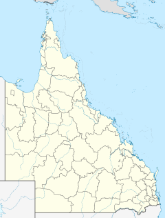
It is situated about 91 kilometres (57 mi) east of Birdsville and 230 kilometres (143 mi) north of Innamincka. The Diamantina River and several of its associated tributaries run through the property.[1] The 292 square kilometres (113 sq mi) Diamantina overflow swamp is situated on Durrie, the swamp is a DIWA nationally important wetland.[2]
The property is owned by S. Kidman & Co. and occupies an area of 6,600 square kilometres (2,548 sq mi) in the Channel Country of far west Queensland. On an average season Durrie is stocked with 9,000 head of cattle.[3]
History[]
The traditional owners of the area are the Karwali peoples who have lived in the area for tens of thousands of years.[4]
Karuwali (also known as Garuwali, Dieri) is a language of far western Queensland. The Karuwali language region includes the landscape within the local government boundaries of the Diamantina Shire Council, including the localities of Betoota and Haddon Corner.[5]
The property was established some time prior to 1897 when it was feared that ticks from cattle in the Northern Territory would infect the Queensland herd unless a quarantine line was formed.[6]
Durrie was taken up in around 1908 by William Naughton, a prominent pastoralist of the time, when it took up an area of 2,000 square miles (5,180 km2) who stocked it over the course of two years with 8,000 head of cattle.[7]
Kidman acquired Durrie in 1913 when he bought it from the Naughton Brothers. Durrie adjoined Monkira and Bluff Stations which were both already owned by Kidman.[8]
The area was struck by drought from 1913 to early 1915 resulting in the deaths of huge numbers of stock. Kidman estimated that he lost 60,000 head on his properties in the Channel Country like Durrie, Diamantina Lakes, Durham Downs, Morney Plains and Carrawilla.[9]
Airmail delivery to remote properties in outback South Australia, New South Wales and Queensland commenced in 1949. Durrie along with other remote properties including Mungerannie, Clifton Hills, Glengyle, Davenport Downs, Morney Plains, Mount Leonard, Mulka, Cordillo Downs, Tanbar, Durham Downs, Nappa Merrie, Lake Pure and Naryilco were also on the route.[10]
After heavy rains in 1950 the Diamantina floodwaters reached records levels and the homestead was inundated. The McAuley family who were living at the homestead had to seek higher ground.[11] The family camped on a nearby sand-hill for a week until the floodwaters receded.[12]
Diamantina Overflow Swamp[]
The swamp extends over 25 kilometres (16 mi) long with a width of up to 22 kilometres (14 mi) that falls within the Diamantina catchment covering a total area of 292 square kilometres (113 sq mi). It is composed of floodplain, swamps and anastomosing channels of the Diamantina River composed of very deep grey cracking clays. The water in the swamp is fresh and remains wet well into the dry season. The major habitats found within the area include vast areas of lignum, Muehlenbeckia florulenta, open shrubland and of sedgeland dominated by Eleocharis between the lignum.[13]
See also[]
References[]
- ^ "Station kids". Australian Broadcasting Corporation. 31 March 2009.
- ^ "Diamantina Overflow Swamp – Durrie Station DIWA nationally important wetland". Department of Environment and Heritage Protection, Queensland. 2012. Retrieved 21 June 2013.
- ^ "Durrie Station - S. Kidman". S. Kidman & Co. 2012. Retrieved 22 June 2020.
- ^ "Karuwali (QLD)". Tindale's Catalogue of Australian Aboriginal Tribes. South Australian museum. 1 November 2011. Retrieved 25 June 2013.
- ^
 This Wikipedia article incorporates CC-BY-4.0 licensed text from: "Indigenous languages map of Queensland". State Library of Queensland. State Library of Queensland. Retrieved 5 February 2020.
- ^ "The Tick question". The Brisbane Courier. Queensland: National Library of Australia. 22 May 1897. p. 7. Retrieved 23 June 2013.
- ^ "History of Queensland – Its people and industries" (PDF). University of Queensland. 2006. p. 225. Retrieved 23 June 2013.
- ^ "Sale of Station property". Morning Bulletin. Rockhampton, Queensland: National Library of Australia. 8 November 1913. p. 6. Retrieved 23 June 2013.
- ^ "The drought in Queensland". The Northern Times. Carnarvon, Western Australia: National Library of Australia. 23 October 1915. p. 2. Retrieved 23 June 2013.
- ^ "Airmail Service For Outback Stations Commences Next Week". Barrier Daily Truth. Broken Hill, New South Wales: National Library of Australia. 15 April 1949. p. 1. Retrieved 23 August 2014.
- ^ "Family Flooded Out Of Homestead". The Advertiser. Adelaide: National Library of Australia. 21 March 1950. p. 1. Retrieved 23 June 2013.
- ^ "To Go Back to Home". The Barrier Miner. Broken Hill, New South Wales: National Library of Australia. 28 March 1950. p. 1. Retrieved 23 June 2013.
- ^ "Directory of Important Wetlands in Australia – Information sheet". Department of Sustainability, Environment, Water, Population and Communities. 2011. Retrieved 23 June 2013.
Coordinates: 25°40′29″S 140°13′55″E / 25.67472°S 140.23200°E
- Stations (Australian agriculture)
- Pastoral leases in Queensland
- Central West Queensland
