Dzibilchaltun
This article needs additional citations for verification. (December 2014) |
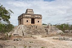 Temple of the Seven Dolls at Dzibilchaltun | |
 Location within Mesoamerica | |
| Location | Yucatán, Mexico |
|---|---|
| Region | Yucatán |
| Coordinates | 21°5′27.60″N 89°35′25.08″W / 21.0910000°N 89.5903000°WCoordinates: 21°5′27.60″N 89°35′25.08″W / 21.0910000°N 89.5903000°W |
| History | |
| Cultures | Maya civilization |


Dzibilchaltún (Yucatec: Ts'íibil Cháaltun, [d̥z̥ʼiː˧˥biɭ tɕʰɒːl˦˥tuŋ]) is a Maya archaeological site in the Mexican state of Yucatán, approximately 10 miles (16 km) north of state capital Mérida.
Location[]
In the view of modern researchers, the ancient builders of Dzibilchaltún may have chosen the site of the city to be as close as possible to the coastal salt-producing region (about 22 km (13.7 mi) away), while still being located on a reasonably fertile and habitable terrain. The region between Dzibilchaltún and the sea coast is less suitable for human habitation, being either mangrove swamps or bare rock.[1]
Overview[]
The site has been continuously occupied for thousands of years, although it has expanded and contracted from mid-sized city to small town more than once in its long history. It is about 30 minutes north of Mérida, and about the same distance south of the location of the impact site of the meteorite that killed the dinosaurs.
Architecture[]
The most famous structure is the Temple of the Seven Dolls, so named because of seven small effigies found at the site when the temple was discovered under the ruins of a later temple pyramid by archaeologists in the 1950s.[2] On the vernal equinox, the site is crowded by visitors observing the sunrise through the temple's doorways, but there is no archaeological feature marking the observation spot; the relationship of the orientation with the equinoxes is thus highly unlikely.[3] The temple is connected to the rest of the site by a sacbe, or "white road," so-called because they were originally coated with white limestone, built over stone-and-rubble fill.
Surroundings[]
The other major feature of Dzibilchaltún is its cenote, Cenote Xlakah, located around the center of the city's ruins. It is thought that the availability of this source of clean drinking water influenced the builders' choice of the location. Archaeological findings retrieved from the cenote by divers indicate that it was the center of a religious cult.[1][2] These days the cenote is used as a swimming hole by local residents and tourists year round.
In this Cenote, just like the one found in Chichen Itza, a large number of archaeological pieces like carved bones and wooden objects, but mainly vases, have been found. Valuable information about the ancient Mayans who lived near the cenote was found here.[4]
Dzibilchaltún also contains the ruin of a 16th-century Spanish church built at the site after the conquest.
The Dzibilchaltun archeological site also includes a visitor center with maps, restrooms and gift shops. The renovated museum housing Mayan artifacts located at the site has re-opened. The museum is closed on Mondays.
See also[]
- List of Mesoamerican pyramids
- List of sinkholes of Mexico
References[]
- ^ Jump up to: a b Kurjack, Edward (2001), "Dzibilchaltún (Yucatán, Mexico)", in Evans, Susan Toby; Webster, David L. (eds.), Archaeology of ancient Mexico and Central America: an encyclopedia, Taylor & Francis US, pp. 227–228, ISBN 0-8153-0887-6
- ^ Jump up to: a b Burgess, Robert F. (1999). "Through the Bottom of the Ocean". The Cave Divers. Locust Valley, New York: Aqua Quest Publications. pp. 71–84. ISBN 1-881652-11-4. LCCN 96-39661.
- ^ Šprajc, Ivan; Sánchez Nava, Pedro Francisco (2013). "Equinoxes in Mesoamerican architectural alignments: prehispanic reality or modern myth?". Anthropological Notebooks. 19: 319–337.
- ^ "Xlakah Cenote in Dzibilchaltun | Mayan Peninsula". Mayan Peninsula. 2018-11-19. Retrieved 2018-11-30.
| Wikimedia Commons has media related to Dzibilchaltun. |
External links[]
| show Maya sites |
|---|

| show Recreational dive sites |
|---|
| show Authority control |
|---|
- Maya sites
- Maya sites in Yucatán
- Former populated places in Mexico
- Tourism in Mexico
- Mesoamerican sites
- Sinkholes of Mexico
- Tourist attractions in Yucatán
- Museums in Yucatán
- Archaeological museums in Mexico
- Landforms of Yucatán
- 1950s archaeological discoveries
- Underwater diving sites in Mexico