Earthworks (engineering)
This article needs additional citations for verification. (March 2015) |
Earthworks are engineering works created through the processing of parts of the earth's surface involving quantities of soil or unformed rock.
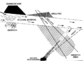
Shoring structures[]
An incomplete list of possible temporary or permanent geotechnical shoring structures that may be designed and utilised as part of earthworks:
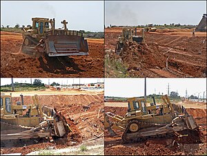
Gallery[]
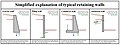
Retaining wall types


Excavation[]

Excavation may be classified by type of material:[1]: 13.1
- Topsoil excavation
- Earth excavation
- Rock excavation
- Muck excavation – this usually contains excess water and unsuitable soil
- Unclassified excavation – this is any combination of material types
Excavation may be classified by the purpose:[1]: 13.1, 13.2
Civil engineering use[]
Typical earthworks include road construction, railway beds, causeways, dams, levees, canals, and berms. Other common earthworks are land grading to reconfigure the topography of a site, or to stabilize slopes.

Military use[]
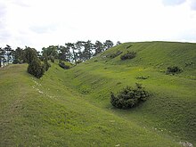
In military engineering, earthworks are, more specifically, types of fortifications constructed from soil. Although soil is not very strong, it is cheap enough that huge quantities can be used, generating formidable structures. Examples of older earthwork fortifications include moats, sod walls, motte-and-bailey castles, and hill forts. Modern examples include trenches and berms.
Equipment[]
Heavy construction equipment is usually used due to the amounts of material to be moved — up to millions of cubic metres. Earthwork construction was revolutionized by the development of the (Fresno) scraper and other earth-moving machines such as the loader, the dump truck, the grader, the bulldozer, the backhoe, and the dragline excavator.
Mass haul planning[]

Engineers need to concern themselves with issues of geotechnical engineering (such as soil density and strength) and with quantity estimation to ensure that soil volumes in the cuts match those of the fills, while minimizing the distance of movement. In the past, these calculations were done by hand using a slide rule and with methods such as Simpson's rule. Earthworks cost is a function of hauled amount x hauled distance. The goal of mass haul planning is to determine these amounts and the goal of mass haul optimization is to minimize either or both.[2]
Now they can be performed with a computer and specialized software, including optimisation on haul cost and not haul distance (as haul cost is not proportional to haul distance).
See also[]
- Contour trenching – Conservation technique in agriculture
- Cut and fill – Earthmoving technique to minimize labor
- Earth movers, construction/engineering vehicles used for earthworks civil engineering
- Earth structure – Building or other structure made largely from soil
- Gabion – Cage full of rock
- Keyline design – Landscaping to optimize water usage
- Land restoration – Reinstatement of damaged landscape
- Grading (earthworks) – In civil engineering, creating a profile
- Spoil tip – Pile built of accumulated spoil
- Subgrade – Material underneath a road or track
- Terrace (earthworks) – Terrain formed by tiered platforms
Calculation software[]

The table below provides a list of software used in the engineering and construction industries to plan, execute and cost these earthworks.
Earthwork software is generally a subset of CAD software, in which case it often an add-on to a more general CAD package such as AutoCAD.[3] In that case, earthwork software is principally used to calculate cut and fill volumes which are then used for producing material and time estimates. Most products offer additional functionality such as the ability to takeoff terrain elevation from plans (using contour lines and spot heights); produce shaded cut and fill maps; produce cross sections and visualize terrain in 3D.[4] The means by which volumes are calculated in software can differ quite considerably leading to potentially different results with the same input data. Many software products use methods based on triangulated irregular networks (TINS) and triangular prism volume algorithms, however other calculation methods are in use based on rationalizing elevations into high density grids or cross-sections.[5][6][7]
A few programs are specialised in earthworks transport optimization and planning the construction works.
| Title | Developer | Stand Alone\Add On | Operating System | Calculation Method | Imports | Exports |
|---|---|---|---|---|---|---|
| 12D | 12D Solutions | Stand Alone | Windows | TIN Prisms | Points (xyz file, dxf, dwg) : Contour Lines\Break Lines (.dxf, .dwg) | ?? |
| Cut+Fill | R Goddard | Stand Alone | Windows & Linux with WINE | TIN & Microgrid | Points (csv) Also allows plotting points by moving mouse over bmp | csv table of results & bmp of cut/fill area |
| n4ce | Applications in CADD | Stand Alone | Windows | Tin Prisms, Grid or Section | Points\Contour Lines\Break Lines\Triangles\Alignments (.dxf, .dwg, xyz file, LandXML, MX Genio, Total Station Raw, GNSS) | Sections, Reports, 3D model, CAD, CSV |
| AEC CutFill | AEC Logic | Add on for AutoCAD | Windows | Cross Section | Cross Sections (AutoCAD XData) | Cross Section (.dxf) |
| Civil 3D | Autodesk | Stand Alone | Windows | TIN Prisms | Points\Contour Lines\Break Lines (.dxf, .dwg) | Surface (.dxf, .dwg) |
| Earthwork 4D | AGTEK | Stand Alone | Windows | High-Density Cross Sections through TIN Surfaces | Points (pnez text file, .dxf, .dwg, .dgn, .xml) : Contour Lines\Break Lines (pnez text file, .dxf, .dwg, .dgn, .xml, .kmz, .kml, .pdf) : Route Alignment Data (station-offset text file, .dxf, .dwg, .dgn, .xml, .pdf) : Surface TINs (pnez text file, .dxf, .dwg, .dgn, .xml, .tn3, .ttm) | Points (pnez text file, .dxf, .dwg, .xml) : Contour Lines\Break Lines (pnez text file, .dxf, .dwg, .xml, .ln3) : Route Alignment Data (station-offset text file, .cgo, .xml) : Surface TINs (pnez text file, .dxf, .dwg, .xml, .tn3, .ttm) : Reports (.csv, .xls, .kmz, .emf, .wrl .pdf) |
| Carlson Takeoff | Carlson Software | Stand Alone or AutoCAD Add on | Windows | TIN Prisms or Grid | Points (xyz file, dxf, dwg) : Contour Lines\Break Lines (.dxf, .dwg, .pdf) | Reports (.pdf, excel) |
| Business Centre HCE | Trimble | Stand Alone | Windows | TIN Prisms | Points (xyz file, dxf, dwg) : Contour Lines\Break Lines (.dxf, .dwg) | ?? |
| InSite SiteWork | InSite Software | Stand Alone | Windows | TIN Prisms | Points (dxf, dwg): Contour Lines\Break Lines (.dxf, .dwg, pdf) | BIM Surface (dwg, dxf), Trimble, Leica, TopCon, LandXML, Reports (pdf, Excel) |
| Earthworks OnScreen | Tally Systems | Integrates with MS Excel | Windows | ?? | Points,Contour Lines\Break Lines (.pdf) | ?? |
| ESurvey Earthwork | ESurveying Softech | Stand Alone | Windows | Grid | Points (xyz file, dxf, dwg) | Reports (Excel) |
| Fast Terrain | Diolkos3D | Stand Alone | Windows | ?? | Points\Contour Lines\Break Lines (.dxf, .dwg) | ?? |
| HCSS Plans | HCSS | Stand Alone | Windows | Not Applicable | Quantity imports from Excel file | Bid item exports to Excel or Word |
| Pizer Earth | Pizer Incorporated | Stand Alone | Windows | Cross Section | Manual Input | Cross Section (.dxf) |
| EarthWorkPro | Planswift | Plug-in for Planswift | Windows | Grid | Manual Input | Report (.csv, Excel, XML, HTML) |
| HEADS Site | Techsoft Engineering Services | Stand Alone | Windows | TIN Prism | Points (xyz file) | Surfaces (.dxf, .dwg) |
| MAGNET Office | Topcon | Stand Alone | Windows | ? | .dwg, .dxf | ascii, .csv, .dwg, .dxf |
| MAGNET Project | Topcon | Stand Alone | Windows | Mass haul optimization, schedule and location based planning, project management | .dwg, .pdf, .xlsm, .xml, .dr5, .mxl, wms map | MS project, .xml, .xlsm, |
| Masster[8] | Egis | ? | ? | Mass haul optimization | ||
| Nonio C \ DomusTerra | Interstudio | Stand Alone | Windows & macOS | ?? | Points\Contour Lines\Break Lines (.dxf, .dwg, xyz file, QD3D) | Surfaces (Domus.Cad, GDL, QuickDraw 3D, Quesa MetaFile). |
| NRG Surveys | NRG Survey Systems | Stand Alone | Windows | ?? | ?? | ?? |
| Mudshark | Brightbox Software | Stand Alone | Windows | Solid Modelling from TIN,TIN Prism | Points (xyz file, dxf, dwg, various image formats) : Contour Lines
(.dxf, .dwg, .pdf, various image formats) |
Cross Sections (.pdf), Results (xml, Microsoft Excel), 3D .dwg/.dxf with results tags, image files of project. |
| Model Maker Systems | Model Maker | Stand Alone | Windows | Grid & Cross Sections | ?? | ?? |
| KeyTERRA-FIRMA | KTF Software | Add on for AutoCAD & BricsCAD | Windows | TIN Prism | Points (xyz file, dxf, dwg) : Contour Lines\Break Lines (.dxf, .dwg) | Cross sections and cut & fill depths as contours or solid colors (.dwg, .dxf); txt report files; Surfaces (.dwg, .dxf, LandXML); Water volume depth graphs |
| Kubla Cubed | Kubla | Stand Alone | Windows | TIN Prism | Points (xyz file, .dwg, .dxf, .xls, .xlsx), Contour Lines\Break Lines (.dwg, .dxf), Surfaces (.dwg, .dxf, LandXML) | Surfaces (.dwg, .dxf, LandXML), Designs (.dwg, .dxf, LandXML) : Report (.doc, .pdf, .xlsx) |
| Earthworks | Trakware | Stand Alone | Windows | TIN Prism | Points (.dwg), Contour Lines\Break Lines ( .dwg) | ?? |
| LSS | DTM Software | Stand Alone | Windows | TIN Prism | Points\Contour Lines\Break Lines (.dxf, .dwg, xyz file, LandXML, MX Genio) | Surfaces (.dxf, LandXML, xyz file) |
| LisCAD | LisTech | Stand Alone | Windows | TIN Prism | Points\Contour Lines\Break Lines (.dxf, .dwg) | Cut & Fill Areas (.dwg, .dgn, LandXML) |
| QuickDIRT | Constructive Computing | Stand Alone | Windows | Grid | Points\Contour Lines\Break Lines (.dxf) | Surface (xyz file) |
| SiteWorks/OS | Vertigraph | Stand Alone | Windows | Grid | Points (xyz file, dxf, dwg), Contour Lines\Break Lines (.dxf, .dwg) | Reports, Surface, Cross Sections (HTML .pdf, Word, Excel) |
| SCC Pro Software | SCC Survey | Stand Alone | Windows | TIN Prism or Grid | support AutoCAD, Microstation, MX MOSS and LandXML | support AutoCAD, Microstation, MX MOSS and LandXML |
| Cut & Fill | Synergy Information Systems | A component of Sage Timberline Office | Windows | ?? | ?? | ?? |
| Terrain Tools | Softtree | Stand Alone | Windows | ?? | Points\Contour Lines (LandXML, xyz File, Arc Grid) | Surface (LandXML, .dxf, .dwg) |
| WinEx Master\WinEx GRADE | Roctek International | Stand Alone | Windows | Super High Density Grid | Points\Contours (.pdf, .dxf, .dwg, Land .xml) Most Image Files, Field Point data | Customer Reports and Excel .Docx, Land.xml, .dxf, .txt, .rtf, .txt |
| TraceAir | TraceAir Technologies Inc | Web-based SaaS | web-browser | Super High Density Grid | Points\Contours (.pdf, .dxf, .dwg, Land .xml) Most Image Files, Field Point data | Maps in .tiff, .pdf and reports in .xls |
| Causeway Estimating | Causeway | Stand Alone | Windows | ?? | Points\Contour Lines(xyz file, .dwg, MX Genio, .pdf) | Surfaces (.dwg, MX Genio) |
| Propeller Platform | Propeller | Stand Alone | web-browser | TIN | Points\Contour Lines\Break Lines (.dxf, .ttm) | Textured OBJ, DEM, GEOTIFF, DXF (3 resolutions), Custom Contours, Ortho GeoTiff, Ortho JPEG, Standard-Density Point Cloud, Compressed LAS |
| Viewpoint Earthwork Software | Viewpoint Construction Software | Stand Alone | Windows & Mac OS | Grid | ?? | ?? |
| DatuBIM | Datumate | Web-based SaaS | web-browser | TIN | Images (JPG), Designs/Surfaces (DXF), Points (CSV) | Reports (PDF), Cross sections, volumes, elevations, areas, points, distances, angles (PDF, DXF), 3D Models (LAS, OBJ), DSM (TIFF), Orthophoto (TIFF), Contours (DXF, SHP), Images (JPG) |
References[]
- ^ Jump up to: a b Frederick S. Merritt, M. Kent Loftin, Jonathan T. Ricketts, Standard Handbook for Civil Engineers, Fourth Edition, McGraw-Hill Book Company, 1995.
- ^ "Earthworks cost optimization through mass haul planning". www.topconplanning.com. Archived from the original on 2 April 2015. Retrieved 7 June 2015.
- ^ "Taking the Measure of Methods for Estimating Earthwork Volumes - Forester Network". Forester Network. Retrieved 2016-02-09.
- ^ "Vertigraph, Inc. -- Automating the Takeoff & Estimating Process". www.vertigraph.com. Archived from the original on 2015-12-15. Retrieved 2016-02-09.
- ^ "How to Estimate Cut and Fill Volumes for Earthworks Projects | Grid Method, Cross Section Method, Earthworks Software". www.kublasoftware.com. Retrieved 2016-02-09.
- ^ "Vertigraph, Inc. -- Calculating Cut and Fill Quantities : Modern Techniques and Best Practices". vertigraph.com. Archived from the original on 2016-01-31. Retrieved 2016-02-10.
- ^ Cheng, Jian-chuan; Jiang, Long-jian (2013-11-06). "Accuracy Comparison of Roadway Earthwork Computation between 3D and 2D Methods". Procedia - Social and Behavioral Sciences. Intelligent and Integrated Sustainable Multimodal Transportation Systems Proceedings from the 13th COTA International Conference of Transportation Professionals (CICTP2013). 96: 1277–1285. doi:10.1016/j.sbspro.2013.08.145.
- ^ Sétra (March 2007). Sétra (ed.). Guide technique, Conception et réalisation des terrassements, Fascicule 1 : études et exécution des travaux (in French). Bagneux. pp. 49–50. ISBN 9782110946430.
External links[]
| hide | |||||||
|---|---|---|---|---|---|---|---|
| Investigation and instrumentation |
| ||||||
| Soil |
| ||||||
| Structures (Interaction) |
| ||||||
| Mechanics |
| ||||||
| Numerical analysis software | |||||||
| Related fields | |||||||
- Fortification (architectural elements)
- Civil engineering
- Earthworks (engineering)