East Coast Greenway
| East Coast Greenway | |
|---|---|
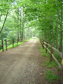 The American Tobacco Trail, which forms 22.6 miles (36.4 km) of the East Coast Greenway in North Carolina | |
| Length | 3,000 miles (4,800 km) |
| Designation | NC State Trail (2021) |
| Trailheads | Maine/Canada–US border-Florida |
| Use | Multi-use, non-motorized |
| Elevation | |
| Highest point | West Boylston, Massachusetts, 680 ft (210 m) |
| Lowest point | Many locations within 10 feet (3.0 m) or less of sea level |
| Hiking details | |
| Season | Variable, depending on latitude |
| Hazards | Weather, tick-borne diseases, poison ivy |
| Website | www |
The East Coast Greenway is a 3,000-mile (4,800 km) rail trail linking the major cities of the Atlantic coast of the United States, from Calais, Maine, to Key West, Florida. The spine route and branching complementary routes are for non-motorized human transportation, including bicyclists, walkers, runners, inline skaters, horseback riders, wheelchair users, and cross-country skiers. In 2020 the greenway received over 50 million visits.[1]
The nonprofit East Coast Greenway Alliance was created in 1991. The entire route has been selected. As of 2021 over 1,000 miles (1,610 km), or 35 percent of the route, is off-road on traffic-protected greenways. The vision is for the entire trail to be off-road.[1]
History[]

In 1991, a group of cyclists and long-distance trail enthusiasts met in New York City and formed a national non-profit organization, the East Coast Greenway Alliance (ECGA), to plan and promote a greenway linking existing and planned trails into a contiguous "spine route" between Atlantic coast cities.
In summer 1992, the ECGA sent nine cyclists from Boston, New York City, Vermont, and Washington, D.C., on a 30-day "exploratory" cycle tour.
In 1993, tours went along the route to explore options and promote the idea of the greenway. In 1994, the first promotional tour took place from Maine to Washington, D.C. "East Coast Greenway" became a trademark in 1995.[citation needed]
The first five trail segments were designated in 1996. These segments were the Baltimore & Annapolis Trail in Maryland, the Charter Oak Greenway in Connecticut, the Coventry Greenway in Rhode Island, the Farmington Canal Greenway in Connecticut, and the Delaware & Raritan Canal Trail in New Jersey. These trails make up 56 miles (90 km) of the greenway.
Between 1997 and 2000, about 150 miles (240 km) of trail segments were designated throughout the region. In 2000, Amtrak became a partner, helping to open access to various parts of the route. Between February and June 2000, the ECG Wave non-motorized relay carried a bottle of seawater from Key West to Canada along the route of the ECG. From 2001 to 2004, another 173 miles (278 km) were designated, and multiple states stepped in to help finalize their section of the route. This brought in more partnerships with government organizations, such as NJDOT, that would be essential for trail development. In 2003, members of the House of Representatives and the Senate signed letters to President Bush in support of the greenway.
In 2004, seven cyclists rode the entire route, from Key West to Calais, in 55 days. Later that year, the first Maine-to-Florida tour was held; four cyclists completed the event in 52 days, raising $75,000. In the following years, more people would complete the ride outside of ECG events. A 2005 GQ magazine article about a ride by Wil Hylton brought national attention to the greenway.
The entire spine route was finalized and mapped in 2008. The accessibility of the trail expanded with support of the states, and more events were held each year.
In 2020, the route reached over 1000 miles of completed off-road greenway.[1] Efforts to increase the amount of off-road routes are continuing. In 2020 the greenway received over 50 million visits.[1]
On June 25, 2021, the North Carolina General Assembly passed a law adding the state's section of the greenway as its tenth State Trail.[2]
Route[]
Major cities connected by the spine route are:
- Calais, Maine
- Bangor, Maine
- Augusta, Maine
- Portland, Maine
- Portsmouth, New Hampshire
- Newburyport, Massachusetts
- Boston, Massachusetts
- Worcester, Massachusetts
- Providence, Rhode Island
- Hartford, Connecticut
- New Haven, Connecticut
- Bridgeport, Connecticut
- Norwalk, Connecticut
- Stamford, Connecticut
- New Rochelle, New York
- New York, New York
- Jersey City, New Jersey
- Newark, New Jersey
- New Brunswick, New Jersey
- Trenton, New Jersey
- Philadelphia, Pennsylvania
- Wilmington, Delaware
- Baltimore, Maryland
- Annapolis, Maryland
- Washington, District of Columbia
- Richmond, Virginia
- Durham, North Carolina
- Raleigh, North Carolina
- Fayetteville, North Carolina
- Wilmington, North Carolina
- Myrtle Beach, South Carolina
- Charleston, South Carolina
- Savannah, Georgia
- Brunswick, Georgia
- Jacksonville, Florida
- St. Augustine, Florida
- Daytona Beach, Florida
- Titusville, Florida
- Melbourne, Florida
- Fort Pierce, Florida
- West Palm Beach, Florida
- Boca Raton, Florida
- Fort Lauderdale, Florida
- Miami, Florida
- Key West, Florida
Other cities may be connected by an alternate route in some locations.
Active segments[]
As of 2016, designated trails and locations of the East Coast Greenway include:[3]
New England region[]
Maine[]

Travelers start in Calais, Maine, at the Canada–US border, and pedal southwest through Ellsworth, where they can stay on the inland spine route through Bangor or veer off along a 150-mile (240 km) coastal route. The routes rejoin north of Portland, then head on towards Portsmouth, New Hampshire. The route through Maine is 350 miles (560 km) long, and 39% of that is currently off-road.[4]
- Calais Waterfront Walkway – Calais
- Moosehorn National Wildlife Refuge Trail – Baring
- Downeast Sunrise Trail – Washington & Hancock counties
- Kennebec River Rail Trail – Augusta, Hallowell, Farmingdale, to Gardiner
- Rotary Centennial Trail – Benton
- Lewiston Riverside Trail – Lewiston
- Lisbon Trail – Lisbon
- Topsham Trail – Topsham
- Androscoggin River Bicycle Path – Brunswick
- Beth Condon Memorial Pathway – Yarmouth
- Martin's Point Bridge – Falmouth to Portland
- Eastern Promenade/Connector/Back Cove Trail – Portland
- South Portland Green Belt – South Portland
- Eastern Trail – Scarborough, Saco, to Old Orchard Beach
New Hampshire[]
Riders enter the state on the Memorial Bridge in Portsmouth, New Hampshire, and follow the coastline to Seabrook and then on to the Massachusetts border. New Hampshire has the shortest portion of the greenway: about 17 miles (27 km), all on-road.[5]
On August 14, 2019, the New Hampshire Executive Council approved the purchase of Pan Am Railways' abandoned rail corridor from Hampton to Portsmouth for $5 million, to be part of the New Hampshire Seacoast Greenway, a segment of the East Coast Greenway. The 9.6-mile (15.4 km) corridor runs through Hampton, North Hampton, Rye, Greenland, and Portsmouth, and will connect to the south with corridor already purchased by the state but not yet developed. The purchase was paid for with federal funds: eighty percent from the Congestion Mitigation and Air Quality program, and twenty percent from turnpike toll credits.[6]
Massachusetts[]

The greenway enters the state near Salisbury, Massachusetts, and heads south towards Boston and then to Waltham. Next, it travels on from Worcester to the Rhode Island border. The route travels along the Charles River and past the birthplace of the American Industrial Revolution.
- Border to Boston Trail – Salisbury, Newburyport, Wenham, Danvers, to Peabody
- Peabody Independence Greenway – Peabody
- Salem Bike Path – Salem
- Lynn Beach Promenade – Lynn
- Lynnway Sidepath – Lynn
- Northern Strand Community Trail – Malden to Everett
- Everett Bike Path – Everett
- North Bank Park Path – Boston to Cambridge
- Charles River Bike Path – Boston, Watertown, Newton, to Waltham
- Blackstone River Bikeway – Worcester to Millbury & Uxbridge to Blackstone
Rhode Island[]
The greenway enters from Massachusetts on the Blackstone River Bikeway and follows the historic Blackstone Canal. It travels down to Pawtucket and then into Providence, where it goes around India Point Park at Narragansett Bay, and then on to Cranston. This 49-mile (79 km) section of greenway is 52% off-road, with another 30% being developed.[7]
- Blackstone River Greenway – Woonsocket, Cumberland, to Lincoln
- East Bay Bike Path – East Providence to Warren
- Providence Riverwalk in Waterplace Park – Providence
- Washington Secondary Rail Trail, which combines:
- Cranston Bike Path – Cranston
- Warwick Greenway – Warwick
- West Warwick Greenway – West Warwick
- Coventry Greenway and Trestle Trail – Coventry
Connecticut[]
Connecticut has the most rural stretch of trail in the region. It runs through historic mill towns, such as Willimantic, and major cities like Hartford, New Haven, Bridgeport, and Stamford. Users can travel on the Farmington Canal Greenway to get to New Haven from Simsbury and then ride along the Long Island Sound as they exit the state. Currently, 28% of the 198-mile (319 km) route is off-road, with an additional 28% in development.[8]
- Moosup Valley State Park Trail – Plainfield
- Quinebaug River Trail – Killingly
- Tracy Road Smart Parks Trail – Killingly to Putnam
- Air Line State Park Trail North – Windham County
- Veterans Memorial Greenway – Willimantic
- Charter Oak Greenway – Manchester to East Hartford
- Founders Bridge Path – Hartford to East Hartford
- Phoenix Plaza – Hartford
- Travelers Plaza – Hartford
- Bushnell Park Path – Hartford
- Farmington Canal Heritage Trail – Simsbury, Avon, Farmington, Southington, Cheshire, Hamden, to New Haven
- Savin Rock Trail – West Haven
- Long Wharf Nature Preserve Trail – New Haven
- Silver Sands State Park Path – Milford
Mid-Atlantic region[]
New York[]

The New York segments starts in Westchester County and heads south into New York City through the Bronx and Manhattan. The route travels down sections of Broadway and along the Hudson River, which travelers can cross via the George Washington Bridge or by taking a NY Waterway ferry into New Jersey. New York is home to 44 miles (71 km) of greenway, with 62% of the route, the highest percentage on the greenway, being off-road. In Manhattan, 90% of the trail is off-road.[9] Part of the New York City segment is concurrent with the Empire State Trail, which also goes up the west side of Manhattan but diverges from the East Coast Greenway in the Bronx, heading northward through the state instead of towards Connecticut.
- Shore Road Greenway – Bronx
- Pelham Parkway Greenway – Bronx
- Bronx Park Greenway – Bronx
- Bronx River Pathway – Bronx
- Mosholu Parkway Greenway – Bronx
- Van Cortlandt Park Greenway – Bronx
- Hudson River Greenway – Manhattan
- Randall's Island Greenway – Manhattan
- 103rd Street Footbridge – Manhattan
- East River Esplanade – Manhattan
- NY Waterway Ferry – Manhattan to Jersey City, NJ

New Jersey[]
The New Jersey section of the greenway is accessed from New York across the Hudson River by the George Washington Bridge or ferry, and from Pennsylvania by the Calhoun Street Bridge across the Delaware River. The route travels through Jersey City, Newark, New Brunswick, and Trenton while also traveling through rural areas. New Jersey has the second-highest percentage of off-road trails at 54%.[10]
- Hudson River Waterfront Walkway – Hudson Waterfront – Fort Lee to Jersey City
- Local streets – Jersey City[11]
- Lincoln Park Path – Jersey City
- Lincoln Highway Hackensack River Bridge and Passaic River Bridge (Wittpenn Bridge, once completed circa 2022)[12]
- Newark Riverfront Trail – Newark
- Weequahic Park – Newark
- Rahway River Parkway – Union County
- Black Brook Park Path – Kenilworth
- Lenape Park Path – Union County
- Nomahegan Park Path – Cranford
- Roosevelt Park Path – Metuchen
- Merrill Park Path – Middlesex County
- Middlesex Greenway – Middlesex County
- Donaldson Park Path – Middlesex County
- Johnson Park Path – Piscataway
- Landing Lane Bridge Path – Piscataway & New Brunswick
- D&R Canal Trail – New Brunswick & Trenton
- D&R Canal Towpath – Hamilton & Bordentown
- Calhoun Street Bridge – Trenton, New Jersey, to Morrisville, Pennsylvania
Pennsylvania[]

The greenway travels through the smaller towns of Bucks County, then through the city of Philadelphia, where it passes numerous historical landmarks and travels over Spring Garden Street, which has bike lanes going both ways. The route follows the Schuylkill River Trail south towards Delaware. The 67-mile (108 km) route is 31% off-road, but there is a third of the trail that has no route yet. Planning is being done to close the gaps.[13]
- Delaware Canal State Park Trail – Bucks County
- Bristol Spur Line Park Trail – Bristol
- Pennypack Creek Park Trail – Philadelphia
- Port Richmond Trail – Philadelphia
- K&T Trail at Lardner's Point Park – Philadelphia
- Penn Street Trail – Philadelphia
- Schuylkill River Trail – Philadelphia
- Bartram's Gardens Trail – Philadelphia
- Grays Ferry Crescent – Philadelphia
- Cobbs Creek Trail – Philadelphia
- 58th Street Connector – Philadelphia
- Heinz NWR Trail – Philadelphia
- Route 291 Sidepath – Eddystone
- Chester Riverwalk – Chester
Delaware[]

The greenway runs for 43 miles (69 km) through Delaware. Greenway users travel down the Northern Delaware Greenway to historic Wilmington and continue on to the Christina Riverwalk. Next, travelers head to historic New Castle and ride along the New Castle Riverfront before reaching Newark and heading west towards Maryland.[14]
- Northern Delaware Greenway – New Castle County
- Christina Riverwalk – Wilmington
- Jack A. Markell Trail – New Castle
- New Castle Riverfront Greenway – New Castle
- Penn Farm Trail – New Castle
- Churchmans Road sidepath – New Castle County
- Delaware Route 4 sidepath – New Castle County
- Library Road sidepath – Newark
- James F. Hall Trail – Newark

Maryland[]
The route starts in Elkton, Maryland, and heads west to Perryville and the Susquehanna River. Travelers pass the Perry Point VA Medical Center and have great views of the Chesapeake Bay. They cross the Susquehanna at the Thomas J. Hatem Memorial Bridge, but they are limited to crossing between dawn and dusk on weekends, holidays, and special events that have been arranged in advance, and they must be at least 18 years old or have a valid driver's license.[15] Havre de Grace is after the bridge, followed by Harford County, Monkton, and Cockeysville. Next, riders travel south through Baltimore and then on to Annapolis before finishing the 166-mile (267 km) stretch of greenway in Hyattsville and entering Washington, D.C. About 32 percent of the route is off-road.[16]
- Torrey C. Brown Rail Trail – MD border to Ashland (Cockeysville)
- Jones Falls Trail – Baltimore
- Gwynns Falls Trail – Baltimore
- BWI Trail – BWI Airport
- Baltimore & Annapolis Trail – Glen Burnie to Annapolis
- Colonial Annapolis Maritime Trail System – Annapolis
- South Shore Trail – Anne Arundel County
- Odenton Road Bicycle Path – Odenton
- Washington, Baltimore and Annapolis Trail – Anne Arundel County
- Anacostia Tributary Trail System – Prince George's County
District of Columbia[]

The trail splits in Bladensburg, Maryland, just before it reaches Washington, D.C. Travelers can follow the Metropolitan Branch Trail, which runs past Union Station; or the Anacostia Riverwalk Trail, which follows the Anacostia River past the Washington Navy Yard. The two trails rejoin at the National Mall, the ECG's official midpoint, then head for Virginia via the Arlington Memorial Bridge over the Potomac River. Just under half of the 8-mile (13 km) segment through the District is off-road; the downtown area offers no off-road option.[17]
- Metropolitan Branch Trail
- Anacostia Riverwalk Trail
- National Mall Path
South Atlantic region[]
Virginia[]
Leaving Washington, D.C., travelers pick up the Mount Vernon Trail to Mount Vernon, head towards Fredericksburg on the Potomac Heritage Trail, and continue on to the state capital of Richmond. At this point, the greenway splits: the 300-mile (480 km) spine route (16% off-road) continues southwest to the Piedmont region of North Carolina. The alternate route, the 140-mile (230 km) Historic Coastal Route (46% off-road), travels southeast through Jamestown and Williamsburg, then towards Wilmington, North Carolina.[18]
- Mount Vernon Trail – Arlington Memorial Bridge, Washington, D.C., to Mount Vernon
- Silverbrook Road Multi-use Trail – Fairfax County
- Ox Road Multi-use Trail – Fairfax County
- Richmond Highway Multi-use Trail – Fairfax County
- Telegraph Road Multi-use Trail – Fairfax County
- Fairfax County Parkway Multi-use Trail – Fairfax County
- Grist Mill Park Multi-use Trail – Fairfax County
- Virginia Central Railway Trail – Fredericksburg
- Ashland Railside Park Trail – Ashland
- Cannon Creek Greenway – Cannon Creek Greenway
- Belle Isle Bridge – Richmond
- Belle Isle Trail – Richmond
- Lower Appomattox River Trail – Petersburg
- Tobacco Heritage Trail – Lawrenceville, La Crosse, to Brodnax
- Virginia Capital Trail – Richmond to Williamsburg
North Carolina[]
The Greenway's spine route travels south through rural North Carolina into the Research Triangle Region, passing through Durham, Raleigh, and Cary. This section is on the American Tobacco Trail, which runs past the East Coast Greenway Alliance Headquarters in Durham. The route continues southwest through the Sandhills region and into Fayetteville before following the Cape Fear River into Wilmington and traveling along the coast. Alternatively, the Historic Coast Route, entering from southeastern Virginia, moves onto the Dismal Swamp Canal Trail and follows the coast down through Greenville and Jacksonville before reaching Wilmington where the routes connect. The 372-mile (599 km) spine route is 25% off-road at this time.[19] The state designated the greenway as a part of its State Trail System.[2]

- Ellerbe Creek Trail – Durham
- South Ellerbee Creek Trail – Durham
- Downtown Trail – Durham
- American Tobacco Trail – Durham County, Chatham County, to Wake County
- Black Creek Greenway – Cary
- White Oak Greenway – Cary, Apex
- Umstead State Park Trail – Wake County
- Reedy Creek Greenway – Raleigh
- Walnut Creek Trail – Raleigh
- Rocky Branch Trail – Raleigh
- Pullen Park Trail – Raleigh
- Little Rock Trail – Raleigh
- Lower Walnut Creek Trail – Raleigh
- Chavis Way Sidepath – Raleigh
- Central Raleigh Trail – Raleigh
- Neuse River Trail – Raleigh & Clayton
- Buffalo Creek Greenway – Smithfield
- Dunn-Erwin Trail – Dunn & Erwin
- South Tar River Greenway - Greenville
- Cape Fear River Trail – Fayetteville
- Jacksonville Rail-Trail – Jacksonville
- Greenfield Lake Path – Wilmington
- Wilmington Riverwalk – Wilmington
- Cross-City Greenway – Wilmington
- Dismal Swamp Canal Trail – South Mills
- Carolina Beach Greenway – Carolina Beach
- North Carolina Aquarium at Fort Fisher Trail – Kure Beach
- Southport to Fort Fisher Ferry
- Emerald Path – Emerald Isle
South Carolina[]

The 270-mile (430 km) trail travels along South Carolina's coast through Myrtle Beach, Georgetown, Charleston, and Beaufort. The route is 15% off-road, with 20% more in development.[20]
- North Myrtle Beach Greenway, Barefoot Resort Segment – North Myrtle Beach
- Colonel Robert Bell Pass Trail – Myrtle Beach
- Grissom Parkway Trail – Myrtle Beach
- Harrelson Boulevard Trail – Myrtle Beach
- King's Highway Trail – Myrtle Beach
- Waccamaw Neck Bikeway – Litchfield, Murrells Inlet, to Pawleys Island
- Ben Sawyer Boulevard Sidepath – Mount Pleasant to Sullivan's Island
- Garret P. Wonders Memorial Bike/Ped Lane – Charleston to Mount Pleasant
- East Bay Trail – Charleston
- West Ashley Greenway – Charleston
- New River Trail – Bluffton
Southeast region[]
Georgia[]

Greenway riders in Georgia will use the Coastal Georgia Greenway to travel from South Carolina to Florida. The route travels through Savannah, Richmond Hill, Midway, Riceboro, Darien, Brunswick, Woodbine, Kingsland, and St. Marys. The 160-mile (260 km) route is only 6% off-road but has another 14% in development. There are 41 miles (66 km) of gaps, but efforts are being made to connect the route.[21][22]
- Belles Ferry – Savannah
- Triplett Park Trail – Savannah
- Chief O.F. Love Trail – Chatham County
- Canebrake Rd Sidepath – Chatham County
- Highlander Trail – Darien
- Marshes of Glynn Trail – Brunswick
- White Oak Trail – White Oak
- Woobine Riverwalk – Woodbine
- St. Marys Downtown Trail – St. Marys
Florida[]

The Florida section of the ECG starts in Fernandina Beach and travels south along the coast through small beach towns and major cities, such as Jacksonville and Miami. The route continues down through islands and bridges to the southernmost point of the continental United States, Key West. This segment of greenway is 600 miles (970 km) long, the longest of the ECG, and is 31% off-road. There is another 13% in development and another 38% in public control and is to be developed. There are some gaps.[23]
- Amelia Island Trail – Nassau County
- River to Sea Trail – Flagler County
- Jacksonville North Bank Riverwalk – Jacksonville
- St. Johns River Ferry – Ft. George to Mayport
- Timucuan Trail – Jacksonville
- Palatka–St. Augustine State Trail – St. Johns County
- Mickler Trail – St. Augustine Beach
- Halifax River Trail – Holly Hill to Daytona Beach
- Spring-to-Spring Trail – Volusia County
- East Coast Central Regional Rail Trail – Volusia County
- A1A Sidepath – Brevard County
- Prima Vista Blvd Sidepath – St. Lucie County
- Walton Rd Sidepath – St. Lucie County
- Green River Parkway Trail – Martin County to Port St. Lucie
- Seabranch Trail – Martin County
- Jupiter Riverwalk – Jupiter
- West Palm Beach Trail – West Palm Beach
- A1A Sidepath – Boca Raton
- Hollywood Broadwalk – Hollywood
- Atlantic Greenway – Miami Beach
- M Path Trail – Miami-Dade County
- South Dade Rail Trail – Miami-Dade County
- Overseas Heritage Trail – Key Largo to Key West
East Coast Greenway Alliance[]
The East Coast Greenway Alliance (ECGA) is a nonprofit organization that oversees, but does not own, the greenway. The Alliance is based in Durham, North Carolina, next to the American Tobacco Trail. Six Greenway coordinators work remotely in their regions.
The Alliance coordinates the Greenway's growth by working with local, state, regional, and national organizations and agencies. The Alliance is in charge of designating new trail segments and finding routes for the greenway, posting signs designating the path, spreading awareness of the project, and providing maps and information about the greenway.
ECGA advocates for safe access to bike paths on roadways and bridges, as well as convenient access to public transportation for cyclists. In addition, the Alliance promotes the use of alternate transportation, such as use of greenways.[24]
Awards[]
- Named one of the National Millennium Trails by the White House in 1999[25]
- Kodak American Greenway Award in 1999 by The Conservation Fund in Washington, DC, by the National Geographic Society[26]
- GoSmart Golden Modes Community Impact Award in 2015[27]
- GSK IMPACT Award in 2015[28]
- Bicycle Friendly Business for 2016 – 2020 by the League of American Bicyclists[29]
See also[]
- Appalachian Trail
- Ohio River Trail
- List of rail trails
- U.S. Bicycle Route 1
References[]
- ^ Jump up to: a b c d "East Coast Greenway Alliance 2020 Annual Report" (PDF). East Coast Greenway. 2021-01-01. Retrieved 2021-08-29.
- ^ Jump up to: a b "Session Law 2021-54". Raleigh, North Carolina: General Assembly of North Carolina. June 25, 2021. Retrieved June 28, 2021.
- ^ "East Coast Greenway » Designated Trail List". www.greenway.org. Archived from the original on 2016-06-07. Retrieved 2016-06-06.
- ^ "East Coast Greenway » Maine". www.greenway.org. Archived from the original on 2016-08-06. Retrieved 2016-06-09.
- ^ "East Coast Greenway » New Hampshire". www.greenway.org. Archived from the original on 2016-06-23. Retrieved 2016-06-09.
- ^ Tracy, Paula (August 14, 2019). "$5M Seacoast Rail Trail land deal approved". Seacoast Online. Retrieved August 15, 2019.
- ^ "East Coast Greenway » Rhode Island". www.greenway.org. Archived from the original on 2015-08-12. Retrieved 2016-06-09.
- ^ "East Coast Greenway » Connecticut". www.greenway.org. Archived from the original on 2016-05-31. Retrieved 2016-06-09.
- ^ "New York". Archived from the original on 2016-05-25.
- ^ "New Jersey". Archived from the original on 2016-06-23.
- ^ https://jerseydigs.com/jersey-city-becomes-part-continuous-3000-mile-east-coast-bike-path/
- ^ "New bike, walking trail would link N.J.'s 2 largest cities". 27 March 2017. Retrieved 27 March 2017.
- ^ "Pennsylvania". Archived from the original on 2016-06-23.
- ^ "Delaware". Archived from the original on 2016-07-03.
- ^ Anderson, David (August 24, 2016). "Hatem Bridge bike riders will be limited to weekends, holidays starting Sept. 6". The Aegis. Baltimore Sun Media Group. Retrieved September 18, 2016.
- ^ "East Coast Greenway » Maryland". www.greenway.org. East Coast Greenway Alliance. Archived from the original on June 7, 2017. Retrieved June 14, 2017.
- ^ "Washington, D.C." Explore By State. East Coast Greenway. Archived from the original on November 18, 2015. Retrieved June 15, 2016.
- ^ "East Coast Greenway » Virginia". www.greenway.org. Archived from the original on 2016-06-12. Retrieved 2016-06-13.
- ^ "East Coast Greenway » North Carolina". www.greenway.org. Archived from the original on 2016-06-16. Retrieved 2016-06-13.
- ^ "East Coast Greenway » South Carolina". www.greenway.org. Archived from the original on 2016-06-03. Retrieved 2016-06-13.
- ^ "155 Mile Trail System ~ Coastal Georgia". coastalgeorgiagreenway.org. Archived from the original on 2016-08-12. Retrieved 2016-06-13.
- ^ "East Coast Greenway » Georgia". www.greenway.org. Archived from the original on 2016-06-06. Retrieved 2016-06-13.
- ^ "East Coast Greenway » Florida". www.greenway.org. Archived from the original on 2016-06-08. Retrieved 2016-06-13.
- ^ "Strategic Plan" (PDF). Archived from the original (PDF) on 2016-06-15.
- ^ "Millennium Trails". Archived from the original on 2016-05-31.
- ^ "East Coast Greenway » History of the ECG". www.greenway.org. Archived from the original on 2016-06-08. Retrieved 2016-06-08.
- ^ "GoSmart". www.gosmartnc.org. Archived from the original on 2016-07-07. Retrieved 2016-06-08.
- ^ "Ten innovative nonprofits receive $40,000 GSK IMPACT Awards for contributing to a healthier Triangle region | GSK". us.gsk.com. Archived from the original on 2016-07-01. Retrieved 2016-06-08.
- ^ "Award Database". League of American Bicyclists. Retrieved 2016-06-08.
External links[]
| show Hiking trails in Washington, D.C. |
|---|
| show Hiking trails in Maryland |
|---|
| show Hiking trails in Massachusetts |
|---|
| show Hiking trails in New Jersey |
|---|
| show Hiking trails in New York |
|---|
| show Hiking trails in Rhode Island |
|---|
| show Rail trails in New York by county |
|---|

| show Hiking trails in North Carolina |
|---|
| show Rail trails in Pennsylvania |
|---|
| show Hiking trails in South Carolina |
|---|
| show Rail trails in South Carolina |
|---|
| show Hiking trails in Virginia |
|---|
| show Protected areas of Massachusetts |
|---|
| show Protected areas of New York |
|---|
| show Protected areas of Pennsylvania |
|---|
- Rail trails in New York (state)
- East Coast Greenway
- Long-distance trails in the United States
- Rail trails in Maine
- Rail trails in New Hampshire
- Rail trails in Massachusetts
- Rail trails in Rhode Island
- Rail trails in Connecticut
- Rail trails in New Jersey
- Hiking trails in New Jersey
- Rail trails in Pennsylvania
- Rail trails in Delaware
- Rail trails in Maryland
- Rail trails in Virginia
- Rail trails in North Carolina
- Rail trails in South Carolina
- Rail trails in Georgia (U.S. state)
- Rail trails in Florida
- Greenways in New York City
- 1996 establishments in the United States