Eastern Cape
Eastern Cape
| |
|---|---|
 Coat of arms | |
| Motto(s): Development through Unity | |
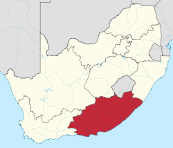 Location of the Eastern Cape in South Africa | |
| Country | |
| Established | 27 April 1994 |
| Capital | Bhisho |
| Largest city | Port Elizabeth |
| Districts | show
List |
| Government | |
| • Type | Parliamentary system |
| • Premier | Oscar Mabuyane (ANC) |
| • Legislature | Eastern Cape Provincial Legislature |
| Area [1]:9 | |
| • Total | 168,966 km2 (65,238 sq mi) |
| Area rank | 2nd in South Africa |
| Highest elevation | 3,019 m (9,905 ft) |
| Lowest elevation | 0 m (0 ft) |
| Population | |
| • Total | 6,562,053 |
| • Estimate (2021) | 6,676,590 |
| • Rank | 4th in South Africa |
| • Density | 39/km2 (100/sq mi) |
| • Density rank | 6th in South Africa |
| Population groups [1]:21 | |
| • Black | 86.3% |
| • Coloured | 8.3% |
| • White | 4.7% |
| • Indian or Asian | 0.4% |
| Languages [1]:25 | |
| • Xhosa | 78.8% |
| • Afrikaans | 10.6% |
| • Zulu | 5.6% |
| • English | 2.5% |
| Time zone | UTC+2 (SAST) |
| ISO 3166 code | ZA-EC |
| HDI (2019) | 0.671[3] medium · 9th |
| Website | www.ecprov.gov.za |
The Eastern Cape (Xhosa: eMpuma-Koloni or Afrikaans: Oos-Kaap) is one of the provinces of South Africa. Its capital is Bisho, but its two largest cities are East London and Port Elizabeth.
The second largest province in the country (at 168,966 km2) after Northern Cape, it was formed in 1994 out of the Xhosa homelands or bantustans of Transkei and Ciskei, together with the eastern portion of the Cape Province. The central and eastern part of the province is the traditional home of the indigenous Xhosa people. In 1820 this area began to be settled by Europeans who originally came from England and some from Scotland and Ireland.
History[]
The Eastern Cape as a South African Province came into existence in 1994 and incorporated areas from the former Xhosa homelands of the Transkei and Ciskei, together with what was previously part of the Cape Province. This resulted in several anomalies including the fact that the Province has four supreme courts (in Grahamstown, Port Elizabeth, Bhisho and Mthatha) and enclaves of KwaZulu-Natal in the province. The latter anomaly has fallen away with amendments to municipal and provincial boundaries.
Mpondo people are more closely related to Xhosa, as they use Xhosa as their main home language. There are other tribes that erroneously referred to as Xhosa people such as: AmaMpondo, AbaThembu, AmaMpondomise, AmaHlubi, AmaBhaca, AmaXesibe, AmaBomvana and other tribes.[original research?]
European settlers[]
In the late 18th century the Dutch Cape Colony slowly expanded eastwards from its original centre around Cape Town. This led to the establishment in 1786 of the Dutch settlement of Graaff-Reinet – named for the Governor of the Cape Colony Cornelius Jacob van de Graaff (in office: 1785–1791) and for his wife Hester Cornelia van de Graaff (née Reynet). Later, during the Napoleonic wars of 1803–1815, Britain took control of the Cape Colony (1806) and encouraged British citizens to migrate there as a means to boost the British population[citation needed] in the area.
From the early 1800s until the formation of the Union of South Africa in 1910, the Eastern Cape saw colonisation by British migrants. English settlers established most of the towns, naming them either for places in England or for the original founders. British colonisation saw schools, churches, hospitals, town centres and government buildings built to speed up development.[citation needed] Some of the older European settlements include: Grahamstown(1812), Port Elizabeth (1820), Salem (1820), Bathurst (1820),East London (1836), Paterson (1879), Cradock (1814) and King William's Town.
Notable people[]
Law and government[]
The first premier was Raymond Mhlaba and the current premier is Oscar Mabuyane, both of the African National Congress. The province is served by the capital of Bhisho next to King Williams Town. The parliament and other important government buildings are situated in the precinct. The High Court that is superior to all courts in the region is situated in Grahamstown and has local seats in Port Elizabeth, East London and Bhisho.
Geography[]
The Eastern Cape gets progressively wetter from west to east. The west is mostly semiarid Karoo, except in the far south, which is temperate rainforest in the Tsitsikamma region. The coast is generally rugged with interspersed beaches. Most of the province is hilly to very mountainous between Graaff-Reinet and Rhodes including the Sneeuberge (English: Snow Mountains), Stormberge, Winterberge and Drakensberg (English: Dragon Mountains). The highest point in the province is Ben Macdhui at 3001 m. The east from East London and Queenstown towards the KwaZulu-Natal border – a region known previously as Transkei – is lush grassland on rolling hills, punctuated by deep gorges with intermittent forest.
Eastern Cape has a coast on its east which lines southward, creating shores leading to the south Indian Ocean. In the northeast, it borders the following districts of Lesotho:
- Mohale's Hoek District – west of Quthing
- Quthing District – between Mohale and Qacha's Nek
- Qacha's Nek District – east of Quthing
Domestically, it borders the following provinces:
- Western Cape – west
- Northern Cape – northwest
- Free State – north
- KwaZulu-Natal – far northeast
Climate[]
Climate is highly varied. The west is dry with sparse rain during winter or summer, with frosty winters and hot summers. The area Tsitsikamma to Grahamstown receives more precipitation, which is also relatively evenly distributed and temperatures are mild. Further east, rainfall becomes more plentiful and humidity increases, becoming more subtropical along the coast with summer rainfall. The interior can become very cold in winter, with heavy snowfalls occasionally occurring in the mountainous regions between Molteno and Rhodes.
- Port Elizabeth: Jan Max: 25 °C, Min: 18 °C; Jul Max: 20 °C, Min: 9 °C
- Molteno & Barkly East: Jan Max 28 °C, Min 11 °C; Jul Max: 14 °C, Min: -7 °C
Tourism[]

The landscape is extremely diverse. The western interior is largely arid Karoo, while the east is well-watered and green. The Eastern Cape offers a wide array of attractions, including 800 kilometres (500 mi) of untouched and pristine coastline along with some particularly splendid beaches, and "big-five" viewing in a malaria-free environment.
The Addo Elephant National Park, situated 73 kilometres (45 mi) from Port Elizabeth, was proclaimed in 1931. Its 743 km² offers sanctuary to 170 elephants, 400 Cape buffalo and 21 black rhino of the very scarce Kenyan sub-species.
The province is the location of Tiffindell, South Africa's only snow skiing resort, which is situated near the hamlet of Rhodes in the Southern Drakensberg. It is on the slopes of Ben Macdhui, the highest mountain peak in the Eastern Cape (3001 m).
The National Arts Festival, held annually in Grahamstown, is Africa's largest cultural event, offering a choice of the very best of both indigenous and imported talent. Every year for 11 days the town's population almost doubles, as over 50,000 people flock to the region for a feast of arts, crafts, music and sheer entertainment.
Jeffreys Bay is an area with some of the country's wildest coastline, which is backed by some of Africa's most spectacular sub-tropical rainforest. The waters here are noted for having "supertubes", good waves for surfing.
Aliwal North, lying on an agricultural plateau on the southern bank of the Orange River, is a popular inland resort known for its hot springs.[citation needed]
The rugged and unspoilt Wild Coast is a place of spectacular scenery. The coastal areas have been a graveyard for many vessels.
Whittlesea, Eastern Cape, situated in the Amatola Mountains, is known for the first wine estate in the province.[citation needed]
King William's Town, Alice, Queenstown, Grahamstown, Cradock and Fort Beaufort offer some of the best colonial architecture of the 19th century in the province. One is spoilt to choose between two major cities lining the coast, East London and Port Elizabeth.
Economy[]
The Eastern Cape is the poorest province in South Africa and has the highest expanded and official unemployment rate in the country.[4][5][6] Subsistence agriculture predominates in the former homelands, resulting in widespread poverty. A multi billion Rand industrial development zone and deep water port are being developed in Coega to boost investment in export-oriented industries.[7] Overall the province only contributes 8% to the national GDP despite making 13.5% of the population. The real GDP of Eastern Cape stands at an estimated R230.3billion in 2017, making the province the fourth largest regional economy in SA ahead of Limpopo and Mpumalanga.[8]
Agriculture[]
There is much fertile land in the Eastern Cape, and agriculture remains important. The fertile Langkloof Valley in the southwest has large deciduous fruit orchards. In the Karoo there is widespread sheep farming.
The Alexandria-Grahamstown area produces pineapples, chicory and dairy products, while coffee and tea are cultivated at Magwa. People in the former Transkei region are dependent on cattle, maize and sorghum-farming. An olive nursery has been developed in collaboration with the University of Fort Hare to form a nucleus of olive production in the Eastern Cape.
Domestic stock farming is slowly giving way to game farming on large scale. Eco-tourism is resulting in economic benefits, and there is lower risk needed to protect wild, native game against drought, and the natural elements. Habitat loss and poaching pose the greatest problems.
The area around Stutterheim is being cultivated extensively with timber plantations.
The basis of the province's fishing industry is squid, some recreational and commercial fishing for line fish, the collection of marine resources, and access to line-catches of hake.
Industry[]
With three import/export harbours and three airports offering direct flights to the main centres, and an excellent road and rail infrastructure,[citation needed] the province has been earmarked as a key area for growth and economic development in modern South Africa.[citation needed]
The two major industrial centres, Port Elizabeth and East London have well-developed economies based on the automotive industry. General Motors and Volkswagen both have major assembly lines in the Port Elizabeth area, while East London is dominated by the large DaimlerChrysler plant, now known as Mercedes-Benz South Africa.[9]
Environmental-friendly projects include the Fish River Spatial Development Initiative, the Wild Coast SDI, and two industrial development zones, the East London Industrial Development Zone and the Coega IDZ near Port Elizabeth. Coega is the largest infrastructure development in post-apartheid South Africa. The construction of the deepwater Port of Ngqura was completed and the first commercial ship anchored in October 2009.[10]
Other sectors include finance, real estate, business services, wholesale and retail trade, eco-tourism (nature reserves and game ranches) and hotels and restaurants.
Cities[]
- East London
- Port Elizabeth
- Mthatha
- Queenstown
- Grahamstown
- Jeffreys Bay
- Graaff-Reinet
- Port Alfred
- Mdantsane
- Cradock
- King William's Town
- Aliwal North
- Uitenhage
- Kouga
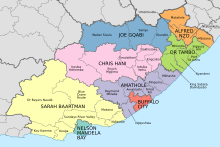
Municipalities[]

- <1 /km²
- 1–3 /km²
- 3–10 /km²
- 10–30 /km²
- 30–100 /km²
- 100–300 /km²
- 300–1000 /km²
- 1000–3000 /km²
- >3000 /km²

The Eastern Cape Province is divided into two metropolitan municipalities and six district municipalities. The district municipalities are in turn divided into 27 local municipalities.
Education[]
Most of the best schools in the province are situated in the suburbs and are known as former "model c" institutions. A large number of black children rather choose to be schooled in them than to attend local schools in their communities due to the standard of teaching and pass levels. The Eastern Cape Department of Education has been roundly criticised for poor primary and secondary education[11] resulting from dysfunction,[12] special interests, and issues with the South Africa teachers union, SADTU.[13][14] The province struggles with a lack of schools; a lack of teachers leading to overcrowding; a lack of textbooks; a lack of basic facilities like toilets, electricity or water; and poor transport infrastructure which regularly absents and endangers learners. This is a huge problem faced in the former Transkei.[15]
By 2011, basic education had so deteriorated that the national Department of Basic Education intervened under section 100(1)(b) of the Constitution of South Africa, taking control of the province's educational administration.[14] The Eastern Cape has since been the worst-performing province educationally and especially in terms of matriculation;[15] matriculants' results averaged 51% in 2009,[16] 58.3% in 2011,[17] 64.9% in 2013,[18] 65.4% in 2014, and 56.8% in 2015.[19][20]
In the 2015/2016 financial year, the province failed to spend R530 million of its allocated R1.5 billion budget for education, most of it intended for infrastructure development.[21][22]
Equal Education's 2017 report, Planning to Fail, found a "systemic failure in Eastern Cape education".[23]
Universities[]
- Rhodes University (Grahamstown)
- Nelson Mandela University (Port Elizabeth)
- University of Fort Hare (main campus in Alice, satellite campuses in Bhisho and East London)
- Walter Sisulu University (campuses in Buffalo City, Gcuwa, Mthatha and Queenstown)
- Pearson Institute of Higher Education (campuses in East London and Port Elizabeth)
Other educational institutions[]
- Lovedale College 1in Alice,1 in KWT
- Buffalo City College, East London
- Queenstown College, Queenstown
- Port Elizabeth College, Port Elizabeth
- Ikhala College, Queenstown
- College of the Transfiguration, Grahamstown
- Eastcape Midlands TVET College (6 campuses in Uitenhage, 1 in Grahamstown, 1 in Graaff-Reinet, and 1 in Port Elizabeth)
- Various independent FET Colleges (Further Education and Training)
Health[]
The province is served by big medical centres such as Cecilia Makiwane Hospital that has undergone a major revamp recently.[when?] Filled with state of the art machinery and more beds. There are many private clinics in most cities and also famous hospitals like Frere in East London and Dora Nginza in Port Elizabeth. Tuberculosis and HIV are the province's leading causes of avoidable deaths, accounting for 9.8% and 5.4% of those deaths. Also known for its traditional black initiation schools, which perform coming-of-age ceremonies involving circumcision and bushwhacking. These have helped to decrease the rate of people contracting HIV and other sexually transmitted infections.[24][25]
Sports[]
- Boxing
- Premier Boxing League
- Checkers/Draughts
- eSports
- Football
- Swallows FC (Alice, McFarlane)
- Blackburn Rovers (East London)
- Chippa United F.C. (Port Elizabeth)
- Cricket
- Chevrolet Warriors (Port Elizabeth)
- Rugby
- Eastern Province Elephants (Port Elizabeth)
- Border Bulldogs (East London)
- Southern Kings (Port Elizabeth)
- Dale High (King William's Town)
- Davidson High (Alice)
- Hudson Park Boys (East London )
- CUESPORT
- Eastern Cape Pool Billiards (8 Ball Pool) – (Port Elizabeth, Uitenhage, Despatch, Jeffreysbay, Humansdorp, St. Francis, East London)
- Eastern Cape Blackball Pool (Port Elizabeth, Queenstown)
- Eastern Cape Billiards and Snooker (Port Elizabeth, East London)
References[]
- ^ Jump up to: a b c d Census 2011: Census in brief (PDF). Pretoria: Statistics South Africa. 2012. ISBN 9780621413885. Archived (PDF) from the original on 13 May 2015.
- ^ Mid-year population estimates, 2021 (PDF) (Report). Statistics South Africa. 19 July 2021. p. 2. Retrieved 19 July 2021.
- ^ "Sub-national HDI – Area Database – Global Data Lab". hdi.globaldatalab.org. Retrieved 13 September 2018.
- ^ "Does SA have highest unemployment rate in the world?". www.thesouthafrican.com. Retrieved 25 August 2021.
- ^ "Mapping poverty in South Africa". southafrica-info.com. Retrieved 31 March 2020.
- ^ "Eastern Cape remains SAs poorest province". dispatchlive.co.za. 23 August 2017. Retrieved 31 March 2020.
- ^ "Billion investments coega special economic zone". biznews.com. Retrieved 31 March 2020.
- ^ "Eastern Cape Economy". ecdc.co.za. Retrieved 31 March 2020.
- ^ "VWSA steps up production as export demand grows". iol.co.za. 20 February 2014. Retrieved 18 May 2020.
- ^ "New liquid bulk tank farm at port of ngqura a step closer – Transnet". rnews.co.za. Retrieved 18 May 2020.
- ^ "As Zuma woos support, Eastern Cape suffers". Times LIVE. 15 April 2012. Retrieved 2 May 2017.
- ^ Ngcukana, Lubabalo (19 February 2016). "Premier's bold plans to deal with the education crisis in Eastern Cape". CityPress. Retrieved 2 May 2017.
- ^ Gqirana, Thulani (6 January 2016). "Eastern Cape is a 'failed state' – education expert". News24. Retrieved 2 May 2017.
- ^ Jump up to: a b John, Victoria. "Special Investigating Unit to probe Eastern Cape education". The M&G Online. Retrieved 2 May 2017.
- ^ Jump up to: a b Motsepe, Tshepo (26 January 2016). "Motshekga has to account for her role in the education crisis – especially in the Eastern Cape". The Daily Maverick. Retrieved 2 May 2017.
- ^ Keet, Jacques. "Matric results a wake-up call for SA". The M&G Online. Retrieved 2 May 2017.
- ^ "Matric pass rate 'a significant achievement'". The M&G Online. 6 January 2011. Retrieved 2 May 2017.
- ^ "Matric: Eastern Cape remains worst province". News24. 6 January 2015. Retrieved 2 May 2017.
- ^ Jemsana, Busisiwe (13 March 2016). "Tripartite alliance to address E Cape education crisis". South African Broadcasting Corporation.[permanent dead link]
- ^ Quintal, Genevieve. "Matric results 2015: Pass rate drops to 70.7%". The M&G Online. Retrieved 2 May 2017.
- ^ Majangaza, Sino (9 March 2016). "R530-million of unspent EC budget meant for poor schools given to other provinces". DispatchLIVE. Retrieved 2 May 2017.
- ^ Phandle, Gugu (24 March 2016). "EC to return unspent R1bn: challenge is 'incapacity to utilise funds'". DispatchLIVE. Retrieved 2 May 2017.
- ^ Damba-Hendrik, Nombulelo (28 April 2017). "Systemic "failure in Eastern Cape education"". Retrieved 28 April 2017.
- ^ "Eastern Cape initiation claims another victim". The M&G Online. 18 June 2008. Retrieved 2 May 2017.
- ^ Koyana, Xolani. "Nine boys in hospital after botched circumcisions". Retrieved 2 May 2017.
External links[]
| Wikivoyage has a travel guide for Eastern Cape. |
- Eastern Cape National Government information
- Eastern Cape Provincial Government
- Eastern Cape Socio-Economic Consultative Council
- Eastern Cape Development Corporation
- www.queenstown.org.za
Coordinates: 32°S 27°E / 32°S 27°E

| show Authority control |
|---|
- Eastern Cape
- Provinces of South Africa
- States and territories established in 1994
- 1994 establishments in South Africa