Uitenhage
Uitenhage | |
|---|---|
| Kariega | |
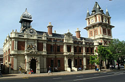 Victoria Tower | |
 Uitenhage | |
| Coordinates: 33°46′S 25°24′E / 33.767°S 25.400°ECoordinates: 33°46′S 25°24′E / 33.767°S 25.400°E | |
| Country | South Africa |
| Province | Eastern Cape |
| Municipality | Nelson Mandela Bay |
| Established | 1804[1] |
| Area | |
| • Total | 75.35 km2 (29.09 sq mi) |
| Elevation | 103 m (338 ft) |
| Population (2011)[2] | |
| • Total | 103,639 |
| • Density | 1,400/km2 (3,600/sq mi) |
| Racial makeup (2011) | |
| • Black African | 23.8% |
| • Coloured | 54.7% |
| • Indian/Asian | 1.2% |
| • White | 18.4% |
| • Other | 1.8% |
| First languages (2011) | |
| • Afrikaans | 68.9% |
| • Xhosa | 17.9% |
| • English | 10.4% |
| • Other | 2.9% |
| Time zone | UTC+2 (SAST) |
| Postal code (street) | 6229 |
| PO box | 6230 |
| Area code | 041 |


Uitenhage (/ˈjuːtənheɪɡ/ YOO-tən-hayg;[3] Afrikaans: [œitənˈɦɑːχə]) officially renamed Kariega[4] is a South African town in the Eastern Cape Province. It is well known for the Volkswagen factory located there, which is the biggest car factory on the African continent. Along with the city of Port Elizabeth and the small town of Despatch, it forms the Nelson Mandela Metropolitan Municipality.
History[]
Uitenhage was founded on 25 April 1804 by landdrost (district magistrate) Jacob Glen Cuyler and named in honour of the Cape's Commissioner-General Jacob Abraham Uitenhage de Mist by the Dutch Cape Colony governor, Jan Willem Janssens.[5] Uitenhage formed part of the district of Graaff Reinet (shortly after its short-lived secession).
The Cape Colony received a degree of independence when "Responsible Government" was declared in 1872. In 1875, the Cape government of John Molteno took over the rudimentary Uitenhage railway site, incorporated it into the Cape Government Railways (CGR), and began construction of the lines connecting Uitenhage to Port Elizabeth and the Southern African interior. Two years later, in 1877, Uitenhage was declared a municipality.[6]
Nearly a hundred years later, as part of the Republic of South Africa, Uitenhage became a centre for resistance against apartheid. In 1985, police opened fire on a funeral procession in Uitenhage, killing a number of unarmed people, in an event that became notorious as an example of police oppression in South Africa under apartheid.[7][8]
In 2001 it was incorporated with Port Elizabeth and Despatch into the Nelson Mandela Bay Metropolitan Municipality. On 23 February 2021, Minister of Sports, Arts and Culture, Nathi Mthethwa approved and gazetted the decision to rename Uitenhage to Kariega along with the neighbouring city of Port Elizabeth which was changed to Gqeberha.[9]
Geography[]
Uitenhage is located 30 km north-west of Port Elizabeth. Its neighbouring town of Despatch, the city of Port Elizabeth and other surrounding areas form the Nelson Mandela Bay Metropolitan Municipality.[10]
Neighbouring towns include Despatch in the south-east and KwaNobuhle in the south.[11]
Uitenhage is also located at the beginning of the Mohair Route which stretches to Graaff-Reinet (considered the centre for mohair farming) via Jansenville on Route 75.
Industries[]
Uitenhage is known for the large industries situated there. The largest of these industries are the Volkswagen and Goodyear factories. An automotive supplier park, Alexander Park Industrial, has also been created directly next to the Volkswagen factory, thus allowing automotive component manufacturers to construct their manufacturing plants close by.
Transport[]
Uitenhage is at the junction of regional and metropolitan routes and has access to many roads. Roads intersecting or running through Uitenhage include the R75, M19, R334 and M10.
- The R75 links to Despatch, Gqeberha in the south and Jansenville and Graaff-Reinet in the north.
- The M19 links to Despatch, Ibhayi and Swartkops.
- The R334 links to Motherwell and Coega to the east and KwaNobuhle and the R102 which also connects to the N2 to Humansdorp and Cape Town.
- The M10 links to Despatch, Bethelsdorp and Port Elizabeth.
Notable people[]
- Allan Hendrickse - Preacher-teacher-politician from apartheid politics[12]
- Anrich Nortje - South African cricketer[13]
- B. J. Vorster - South African Prime Minister 1966 - 1978
- Bicks Ndoni - former mayor of Uitenhage and ANC politician
- Carel Fourie - Springbok rugby wing; from Die Brandwag Hoërskool.[citation needed]
- Charles Robert Redcliffe - Labour Party politician, community leader and anti-apartheid activist.
- Christo van Rensburg - South African tennis player, ATP-ranked[14]
- Deshun Deysel - international business coach and mountaineer.[15]
- Deon Kayser - rugby player.[16]
- Enoch Sontonga - composer of Nkosi Sikelel' iAfrika which is now part of the national anthem.
- Garth Wright - Springbok rugby scrum-half from Muir College[17]
- James Wide - Double leg amputee railway signalman and owner of Jack the signal-baboon.
- Joseph Petrus Hendrik Crowe - British Army officer who was awarded the Victoria Cross
- Johann van der Merwe - Springbok rugby centre 1969/70 British tour; from Die Brandwag Hoërskool.[citation needed]
- Lee-Roy Wright - South African actor and television presenter[18]
- Linky Boshoff - South African tennis player from Riebeek College Girls' High School.
- Loyiso Bala - South African R&B singer; part of Bala Brothers ground and TKZee[19]
- Mcebisi Jonas, former deputy Finance Minister, active member of ANC's Uitenhage branch[20]
- Nantie Hayward - South African cricketer who now plays in the Indian Cricket League
- Okkert Brits - Olympic pole vaulter
- Sean Burke - musician, composer currently based in Randburg, Gauteng[21]
- Smuts Ngonyama - ANC National Spokesman during Thabo Mbeki's Era. Recently appointed South African Ambassador to Spain
- The Invaders[22] - popular South African music group from the 1960s
Notable animals[]
- Jack - A chacma baboon trained to assist signalman James Wide, who had both legs amputated.
Notable buildings[]
This section needs expansion. You can help by . (May 2018) |
Coats of arms[]
Drostdy — In 1804, the Cape colonial government assigned the shield of Jacob Abraham Uitenhage de Mist's arms to the new Uitenhage drostdy. The arms were Sable, a cross moline Argent, i.e. a silver cross moline on a black shield. An anchor was placed behind the shield.[24] The British authorities discontinued the drostdy seals in 1814, and replaced them with the royal coat of arms.[25]
Municipality — In 1881, the Uitenhage municipal council adopted the De Mist arms, complete with a crest consisting of a cross moline issuing from a gold coronet.[26] The arms were registered with the Cape Provincial Administration in September 1956[27] and at the Bureau of Heraldry in June 1994.[28]
Divisional council — The Uitenhage divisional council (the local authority for the rural areas outside the town) assumed a coat of arms in 1968. The arms were granted by the provincial administrator in August 1968[29] and registered at the Bureau of Heraldry in June 1972.[28]
On the arms were stated: "Or, a triple crowned tree Vert, the trunk entwined with the Batavian tricolour; on a chief wavy Sable a cross moline between dexter a pickaxe and hammer in saltire, handles downwards and sinister two scrolls in saltire, Argent." In layman's terms, the design was a golden shield displaying, from top to bottom, a crossed pickaxe and hammer, a cross moline and two crossed scrolls on a black horizontal strip with a wavy edge, and a triple-crowned tree with a Batavian Republic flag wrapped around it.
The crest was an elephant, and the motto Per laborem ad honorem.
References[]
- ^ "Chronological order of town establishment in South Africa based on Floyd (1960:20-26)" (PDF). pp. xlv–lii.
- ^ Jump up to: a b c d "Main Place Uitenhage". Census 2011.
- ^ Lass, Roger (1990), "A 'standard' South African vowel system", in Ramsaran, Susan (ed.), Studies in the Pronunciation of English: A Commemorative Volume in Honour of A.C. Gimson, Routledge, p. 283, ISBN 978-0-41507180-2
- ^ "Two SA airports – and Port Elizabeth – just got official new names". BusinessInsider. Retrieved 2021-02-24.
- ^ "Uitenhage is founded". sahistory. Archived from the original on 15 October 2009. Retrieved 14 February 2010.
- ^ Burman, Jose (1984), Early Railways at the Cape. Cape Town: Human & Rousseau, p.66. ISBN 0-7981-1760-5
- ^ Thornton, R. J. (1990). "The Shooting at Uitenhage, South Africa, 1985: The Context and Interpretation of Violence". American Ethnologist. 17 (2): 217–236. doi:10.1525/ae.1990.17.2.02a00020. JSTOR 645077.
- ^ [1]
- ^ "BREAKING | It is official, Port Elizabeth has a new name — Gqeberha". HeraldLIVE. Retrieved 2021-02-24.
- ^ "Distance Port-Elizabeth, Nelson-Mandela-Bay, Eastern-Cape, ZAF > Uitenhage, Nelson-Mandela-Bay-Metropolitan-Municipality, Eastern-Cape, ZAF - Air line, driving route, midpoint". www.distance.to. Retrieved 2020-08-09.
- ^ "Port Elizabeth Map | South Africa Google Satellite Maps". www.maplandia.com. Retrieved 2020-08-09.
- ^ McGregor, Liz (21 March 2005). "Obituary: The Rev Allan Hendrickse". UD News. Uitenhage. Retrieved 30 August 2016.
- ^ Moonda, Firdose. "Anrich Nortje". ESPNcricinfo. ESPN Sports Media Limited. Retrieved 16 October 2020.
- ^ "Players | ATP Tour | Tennis". ATP Tour.
- ^ Combrinck, Heilie (30 June 2016). "First local TEDx conference hosts famous guests". UD News. Uitenhage. Retrieved 30 August 2016.
- ^ Biyela, Lunga (3 April 2014). "Kayser happy to share". The Witness. Durban. Retrieved 7 October 2017.
- ^ "The Captain's Table: Panel: Garth Wright".
- ^ "Lee-Roy Wright". tvsa.co.za.
- ^ "Nelson Mandela Bay Municipality : Loyiso Bala". nelsonmandelabay.gov.za.
- ^ Reporter, Citizen. "Details: How Mcebisi Jonas could make his political comeback". The Citizen. Retrieved 2018-03-02.
- ^ Artist hits home with Consciousness Hip Hop Archived 2012-05-28 at the Wayback Machine
- ^ Gedye, Lloyd (22 November 2008). "Rise of The Invaders". The M&G Online. Retrieved 2015-07-16.
- ^ Schalk, le Roux (June 2007). "The First Mosque: Caledon Street, Uitenhage" (PDF). Suid-Afrikaanse Tydskrif vir Kultuurgeskiedenis (South African Journal of Cultural History). 21 (1): 59. Retrieved 24 June 2017.
it is deduced that the mosque in Caledon Street was a completed building by March 1849
- ^ Pama, C. (1965) Lions and Virgins.
- ^ Cape Town Gazette 418 (15 January 1814).
- ^ The arms were depicted on a cigarette card issued in 1931.
- ^ Cape of Good Hope Official Gazette 2833 (28 September 1956).
- ^ Jump up to: a b "National Archives of South Africa (NASA) Database Selection". www.national.archsrch.gov.za.
- ^ Cape of Good Hope Official Gazette 3470 (9 August 1968).
Bibliography[]
- Sellick, W.S.J. (1904). Uitenhage, past and present : souvenir of the Centenary, 1804-1904.
External links[]
| Wikimedia Commons has media related to Uitenhage. |
| Wikisource has the text of the 1911 Encyclopædia Britannica article Uitenhage. |
| show Places adjacent to Uitenhage |
|---|
Note: Distances by tarred road as per SA Explorer – Uitenhage Distances
| show Municipalities and communities of Nelson Mandela Bay Metropolitan Municipality, Eastern Cape |
|---|

| show Authority control |
|---|
- Populated places in Nelson Mandela Bay
- Populated places established in 1804