Echt-Susteren
Echt-Susteren
Ech-Zöstere | |
|---|---|
Municipality | |
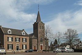
 Church in Nieuwstadt | |
 Flag  Coat of arms | |
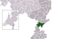 Location in Limburg | |
 Echt-Susteren Location in the Netherlands | |
| Coordinates: 51°6′N 5°52′E / 51.100°N 5.867°ECoordinates: 51°6′N 5°52′E / 51.100°N 5.867°E | |
| Country | Netherlands |
| Province | Limburg |
| Established | 1 January 2003[1] |
| Government | |
| • Body | Municipal council |
| • Mayor | (CDA) |
| Area | |
| • Total | 104.62 km2 (40.39 sq mi) |
| • Land | 103.07 km2 (39.80 sq mi) |
| • Water | 1.55 km2 (0.60 sq mi) |
| Elevation | 30 m (100 ft) |
| Population (January 2019)[5] | |
| • Total | 31,738 |
| • Density | 308/km2 (800/sq mi) |
| Time zone | UTC+1 (CET) |
| • Summer (DST) | UTC+2 (CEST) |
| Postcode | 6100–6118 |
| Area code | 046, 0475 |
| Website | www |

Echt-Susteren (Dutch: [ˌɛxt ˈsʏstərə(n)] (![]() listen); Limburgish: Ech-Zöstere [ˌɛx ˈsœstəʀə]) is a municipality in the southeastern Netherlands. Echt-Susteren was created in 2003 by merging the former municipalities of Echt and Susteren.[6]
listen); Limburgish: Ech-Zöstere [ˌɛx ˈsœstəʀə]) is a municipality in the southeastern Netherlands. Echt-Susteren was created in 2003 by merging the former municipalities of Echt and Susteren.[6]
Susteren is situated in a Euregional area. In the west the municipality borders to Belgium and in the east to Germany. The narrowest is only 4.8 km wide. It is possible to walk from Germany to Belgium via Netherlands in under an hour. The area of Echt-Susteren is a green municipality also known as the green waist of Limburg.
Population centres[]
, , , , Echt, , Gebroek, , , , , Koningsbosch, , Nieuwstadt, , , , , , Roosteren, Schilberg, Sint Joost, , Susteren, .
Echt[]
Echt is a former municipality. It received city rights in 1343.
Susteren[]
Susteren is a former municipality. It received city rights in 1276.
Maria-Hoop[]
Maria-Hoop is a small village in the neighbourhood of the hamlets Echterbosch and Putbroek and the village Koningsbosch. Originally named Diergaarde, the village's named was changed to Maria-Hoop in 1953, after the local church Moeder der H. Hoop.
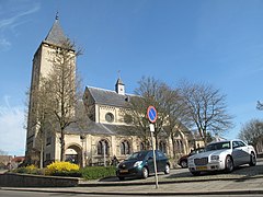
Roosteren[]
The name of the village of Roosteren (population circa 1600, including Kokkelert and Oevereind) was derived from a combination of the Rode Beek (Red Brook) and the town of Suestra (Susteren) leading to the name Roosteren. The village has two 'castles', the Castle Ter Boch and the Castle Eyckholt and a number of Lord Manors. It is located in between the Meuse River (Maas River) and the Juliana Canal (Juliana Kanaal) with a small part of the village separated from the main population centre by the canal: Oud Roosteren (Old Roosteren). The main church is located in Roosteren whereas the cemetery is located near the site of the former church in Old Roosteren.
Topography[]

Dutch Topographic map of the municipality of Echt-Susteren, June 2015
Notable people[]


- Edith Stein (1891–1942) a German Jewish philosopher who converted to Catholicism and became a nun. She is canonized as a martyr and saint of the Catholic Church. Lived in Echt
- Emeri Johannes van Donzel (1925 in Nieuwstadt − 2017) a Dutch historian of the Middle East, particularly Ethiopia
- Frans Wackers (born 1939 in Echt) a medical doctor and research scientist into nuclear cardiology
- Ria Oomen-Ruijten (born 1950 in St Joost) a Dutch politician
- Ien Lucas (born 1955 in Echt) a Dutch visual artist who creates abstract paintings on canvas or wood
- Adrian van Hooydonk (born 1964 in Echt) a Dutch automobile designer and BMW Group's Design Director
- Roland van Vliet (born 1969 in Susteren) a Dutch independent politician
- Laurence Stassen (born 1971 in Sittard) an independent Dutch politician and a former freelance TV presenter; lives in Echt.
Sport[]
- Martin van der Borgh (1934 in Koningsbosch – 2018) a Dutch racing cyclist
- Jan Schröder (1941 in Koningsbosch – 2007) a Dutch professional road and track cyclist.
- Sef Vergoossen (born 1947 in Echt) a former Dutch football manager
Gallery[]
Roosteren, Kerk in straatzicht
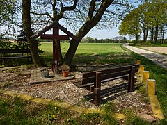
Maria-Hoop (Echt-Susteren) wegkruis Springweg
Nieuwstadt, kerk


References[]
- ^ "Gemeentelijke indeling op 1 januari 2003" [Municipal divisions on 1 January 2003]. cbs.nl (in Dutch). CBS. Retrieved 15 October 2013.
- ^ "Burgemeester" [Mayor] (in Dutch). Gemeente Echt-Susteren. Archived from the original on 17 September 2013. Retrieved 15 October 2013.
- ^ "Kerncijfers wijken en buurten 2020" [Key figures for neighbourhoods 2020]. StatLine (in Dutch). CBS. 24 July 2020. Retrieved 19 September 2020.
- ^ "Postcodetool for 6101CV". Actueel Hoogtebestand Nederland (in Dutch). Het Waterschapshuis. Retrieved 15 October 2013.
- ^ "Bevolkingsontwikkeling; regio per maand" [Population growth; regions per month]. CBS Statline (in Dutch). CBS. 1 January 2019. Retrieved 1 January 2019.
- ^ Ad van der Meer and Onno Boonstra, Repertorium van Nederlandse gemeenten, KNAW, 2011.
External links[]
 Media related to Echt-Susteren at Wikimedia Commons
- Official website
| show Places adjacent to Echt-Susteren |
|---|

| show Authority control |
|---|
- Echt-Susteren
- Belgium–Netherlands border crossings
- Germany–Netherlands border crossings
- Municipalities of Limburg (Netherlands)