Edendale, New Zealand
Edendale | |
|---|---|
 | |
| Coordinates: 46°19′S 168°47′E / 46.317°S 168.783°ECoordinates: 46°19′S 168°47′E / 46.317°S 168.783°E | |
| Country | New Zealand |
| Region | Southland |
| Territorial authority | Southland District |
| Community board | Waihopai-Toetoe |
| Area | |
| • Total | 2.92 km2 (1.13 sq mi) |
| Population (2018 census) | |
| • Total | 588 |
| Postcode(s) | 9825 |
| Area code(s) | 03 |

Edendale is a town in the Southland region of New Zealand's South Island. The township is situated on the Southland Plains just to the west of the Mataura River. Before the town was called Edendale, it was known by the names Maorirua, Mataura Plains and Stuart's Bush.[1]
History[]
Edendale was originally an estate of the New Zealand and Australian Land Company, who surveyed the township and sold it in lots. The estate contained over 120,000 acres. In the course of years the company sold 80,000 acres to hundreds of farmers. The New Zealand and Australian Land Company built the first large scale dairy factory in New Zealand in 1882, and secured a bonus of £500 from the government.[2][3]
The homestead of the Edendale estate was bought in 1902 by its former manager, Mr Donald Macdonald.[4] Macdonald was instrumental in advocating the use of lime on the soils of Southland which vastly improved their quality. The Edendale Homestead is a Category I building listed by the Historic Places Trust.[5] Built circa 1882, the homestead is approach by a mile long drive through a beautiful and mature avenue of native trees, such as totara, black and white kahikatea and matai.[4] Descendants of Mr Macdonald continue to own the property.
Demographics[]
Edendale is defined by Statistics New Zealand as a rural settlement and covers 2.92 km2 (1.13 sq mi). It is part of the wider Edendale-Woodlands statistical area.[6]
The Edendale settlement had a usual resident population of 588 at the 2018 New Zealand census.[7]
Economy[]
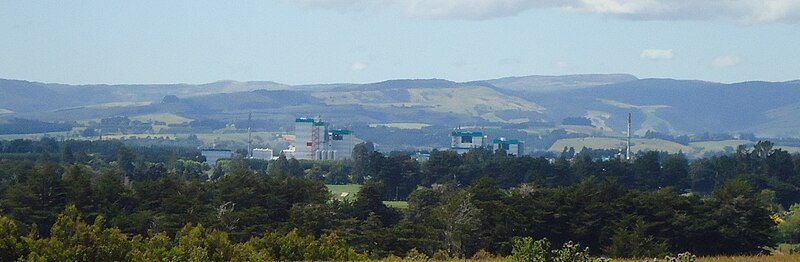
Edendale has a milk processing plant operated by Fonterra which was originally operated by the Southland Dairy Co-operative. The Edendale milk processing plant was a cheese processing plant but in the 1990s expanded to include milk powder processing. The plant has been expanded several times since and was in 2009 the largest raw milk processing plant in the world.[8]
In the main centre of Edendale, there are several small businesses and operations. These include a butcher, a dairy, a garage, a post office and a primary school.
Transport[]
State Highway 1 passes Edendale on its route between Gore and Invercargill. A 2.6 km (1.6 mi) bypass west of the dairy factory opened in December 2019, moving State Highway 1 out of the town itself.[9]
The Main South Line portion of the South Island Main Trunk Railway passes through Edendale, having served the town since April 1875. Although passenger services through the town ceased on 10 February 2002, Edendale had been served by some of New Zealand's premier passenger trains – first the , then the South Island Limited, and finally the Southerner.
Edendale was a railway junction for almost eighty years. On 2 October 1882, a branch line from the South Island Main Trunk, the Wyndham Branch, was opened from Edendale to Wyndham on the opposite side of the Mataura River. On 1 May 1890, this line was extended to . Traffic was light from the beginning, with the extension to Glenham closed on 14 July 1930 and passenger services to Edendale – originally provided by mixed trains and then by RM class Model T Ford railcars – were cancelled on 9 February 1931. By the late 1950s, the line to Wyndham was essentially just an extension of the Edendale railway yard and insufficient quantities of freight meant that the line was closed just weeks before its eightieth anniversary and Edendale ceased to be a railway junction on 9 September 1962.
Education[]
Edendale Primary School is the sole school in Edendale, serving approximately 149 students from Years 1 to 6 (ages 5 to 11).[10] The nearest intermediate and secondary school is Menzies College, 5 km (3 mi) east of the town in Wyndham.
References[]
- ^ Beattie, H. (2 September 1912). "Place Names – Southern Region". The Mataura Ensign. Retrieved 3 January 2017 – via Papers Past.
- ^ "The New Zealand And Australian Land Company, Ltd | NZETC". nzetc.victoria.ac.nz. Retrieved 17 October 2021.
- ^ "Land company's story told". Otago Daily Times Online News. 22 August 2018. Retrieved 17 October 2021.
- ^ a b "Edendale Homestead | NZETC". nzetc.victoria.ac.nz. Retrieved 17 October 2021.
- ^ Southland District Council (2016). "Archaeological Assessment: Edendale SH1 Realignment Project" (PDF).
{{cite web}}: CS1 maint: url-status (link) - ^ "ArcGIS Web Application". statsnz.maps.arcgis.com. Retrieved 15 January 2021.
- ^ "Age and sex by ethnic group (grouped total response), for census usually resident population counts, 2006, 2013, and 2018 Censuses (urban rural areas)". nzdotstat.stats.govt.nz. Retrieved 13 September 2020.
- ^ Hotton, Mike (26 September 2009). "New milk dryer makes Edendale processor 'world's biggest'". The Southland Times. Retrieved 4 October 2009.
- ^ Palmer, Abbey (13 December 2019). "Ahead of time and on budget: SH1 realignment completed". Otago Daily Times Online News. Retrieved 10 February 2021.
- ^ "New Zealand Schools Directory". New Zealand Ministry of Education. Retrieved 22 December 2021.
Further reading[]
- Thwaites, Agnes (2014). Edendale: The Fresh Plains and the Township (Hardback). Wyndham: Edendale Book Committee. ISBN 978-0-473-30603-8.
- Populated places in Southland, New Zealand