Edgartown (CDP), Massachusetts
Edgartown, Massachusetts | |
|---|---|
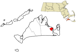 Location in Dukes County in Massachusetts | |
| Coordinates: 41°23′22″N 70°31′3″W / 41.38944°N 70.51750°WCoordinates: 41°23′22″N 70°31′3″W / 41.38944°N 70.51750°W | |
| Country | |
| State | Massachusetts |
| County | Dukes |
| Town | Edgartown |
| Area | |
| • Total | 3.11 km2 (1.20 sq mi) |
| • Land | 3.10 km2 (1.20 sq mi) |
| • Water | 0.01 km2 (0.004 sq mi) |
| Elevation | 5 m (17 ft) |
| Time zone | UTC-5 (Eastern (EST)) |
| • Summer (DST) | UTC-4 (EDT) |
| ZIP Code | 02539 |
| Area code(s) | 508/774 |
| FIPS code | 25-21115 |
| GNIS feature ID | 2631319[2] |

Edgartown is a census-designated place (CDP) comprising the primary settlement in the town of Edgartown, Dukes County, Massachusetts, United States, on the island of Martha's Vineyard. The CDP also includes the neighborhood of Clevelandtown.
Edgartown was first listed as a CDP after the 2010 census.[2]
References[]
- ^ "2020 U.S. Gazetteer Files – Massachusetts". United States Census Bureau. Retrieved May 18, 2021.
- ^ a b c "Edgartown Census Designated Place". Geographic Names Information System. United States Geological Survey.
Municipalities and communities of Dukes County, Massachusetts, United States | ||
|---|---|---|
| Towns | 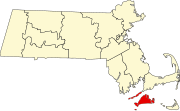 | |
| CDPs | ||
| Other villages | ||
| Indian reservation | ||
| ||
This Dukes County, Massachusetts geography–related article is a stub. You can help Wikipedia by . |
Categories:
- Census-designated places in Dukes County, Massachusetts
- Census-designated places in Massachusetts
- Massachusetts geography stubs