Edgell Bay
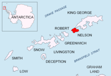
Edgell Bay (62°16′S 58°59′W / 62.267°S 58.983°WCoordinates: 62°16′S 58°59′W / 62.267°S 58.983°W) is a bay 1.5 nautical miles (3 km) long and wide, indenting the northeast side of Nelson Island, in the South Shetland Islands. Spiro Hill overlooks the bay. This bay appears in rough outline on Powell's chart of the South Shetland Islands published in 1822. It was recharted during 1934–35 by Discovery Investigations personnel on the Discovery II, who named it for Vice Admiral , Royal Navy.[1][2]
 WikiMiniAtlas
References[]
- ^ "Edgell Bay". Geographic Names Information System. United States Geological Survey. Retrieved 2012-02-23.
- ^ "Edgell Bay". Gna-GeographicNamesOfTheAntarctic1stEdition1981_djvu. p. 602. Retrieved 2012-02-23.
![]() This article incorporates public domain material from the United States Geological Survey document: "Edgell Bay". (content from the Geographic Names Information System)
This article incorporates public domain material from the United States Geological Survey document: "Edgell Bay". (content from the Geographic Names Information System)
This Nelson Island, South Shetlands location article is a stub. You can help Wikipedia by . |
- Bays of Antarctica
- South Shetland Islands geography stubs