Edinburgh of the Seven Seas
Edinburgh of the Seven Seas
"The Settlement" | |
|---|---|
 Edinburgh of the Seven Seas | |
 Location on Tristan da Cunha | |
| Coordinates: 37°4′2.2″S 12°18′36″W / 37.067278°S 12.31000°W | |
| Sovereign state | |
| British overseas territory | |
| Island | |
| First inhabited | 1816 |
| Named | 1867 |
| Founded by | William Glass (British Army) |
| Named for | Alfred, Duke of Edinburgh |
| Capital of | Tristan da Cunha |
| Population (January 2020) | |
| • Total | 266 |
| Time zone | UTC+0 (GMT) |
| Area code(s) | +44 |


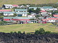
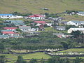
Edinburgh of the Seven Seas is the main settlement of the island of Tristan da Cunha, in Saint Helena, Ascension and Tristan da Cunha, an overseas territory of the United Kingdom, in the South Atlantic Ocean. Locally, it is referred to as The Settlement or The Village.[1]
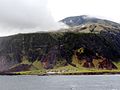
Edinburgh of the Seven Seas is regarded as the most remote permanent settlement on Earth, being 2,173 kilometres (1,350 mi)[2] from the nearest other human settlement, on Saint Helena.
History[]
The settlement was founded on the island of Tristan da Cunha in 1816 by a Sergeant William Glass from Kelso, Scottish Borders after the UK annexed Tristan da Cunha. A military garrison was maintained on the islands as a guard against any French attempts to rescue Napoleon, who was imprisoned on Saint Helena. The military garrison remained until the end of World War II.
It is named after Prince Alfred, Duke of Edinburgh, the second son of Queen Victoria, in honour of his visit to the island in 1867.[3]
Edinburgh of the Seven Seas is the only major settlement of Tristan da Cunha, and contains a small port, the Administrator's residence, and the post office. It was damaged in a volcanic eruption on the island in 1961, which forced the entire population to abandon the settlement and evacuate to Calshot, Hampshire in the UK. The eruption destroyed the settlement's crayfish factory.
After the return of most of the islanders in 1963, the settlement was rebuilt. The harbour at Edinburgh was named Calshot Harbour, after their temporary home during the eruption.[4]
Geography[]
Climate[]
The archipelago has a wet oceanic climate under the Köppen system with mild temperatures, but consistent moderate to heavy rainfall and very limited sunshine, due to the persistent westerly winds. Under the Trewartha classification, Tristan da Cunha is a humid subtropical climate due to the lack of cold weather. The number of rainy days is comparable to the Aleutian Islands at a much higher latitude in the northern hemisphere, while sunshine hours are comparable to Juneau, Alaska, 20° farther from the equator. Frost is unknown below elevations of 500 metres (1,600 ft) and summer temperatures are similarly mild, never reaching 25 °C (77 °F). Sandy Point on the east coast is reputed to be the warmest and driest place on the island, being in the lee of the prevailing winds.
| hideClimate data for Tristan da Cunha | |||||||||||||
|---|---|---|---|---|---|---|---|---|---|---|---|---|---|
| Month | Jan | Feb | Mar | Apr | May | Jun | Jul | Aug | Sep | Oct | Nov | Dec | Year |
| Record high °C (°F) | 23.7 (74.7) |
24.4 (75.9) |
24.4 (75.9) |
22.4 (72.3) |
20.3 (68.5) |
18.7 (65.7) |
17.8 (64.0) |
17.3 (63.1) |
17.1 (62.8) |
18.4 (65.1) |
22.4 (72.3) |
21.8 (71.2) |
24.4 (75.9) |
| Average high °C (°F) | 20.4 (68.7) |
21.2 (70.2) |
20.5 (68.9) |
18.9 (66.0) |
16.9 (62.4) |
15.3 (59.5) |
14.4 (57.9) |
14.2 (57.6) |
14.3 (57.7) |
15.4 (59.7) |
17.0 (62.6) |
18.9 (66.0) |
17.3 (63.1) |
| Daily mean °C (°F) | 17.9 (64.2) |
18.8 (65.8) |
17.9 (64.2) |
15.4 (59.7) |
14.6 (58.3) |
13.1 (55.6) |
12.2 (54.0) |
11.9 (53.4) |
12.0 (53.6) |
13.0 (55.4) |
14.6 (58.3) |
16.5 (61.7) |
14.8 (58.6) |
| Average low °C (°F) | 15.4 (59.7) |
16.2 (61.2) |
15.3 (59.5) |
11.9 (53.4) |
12.3 (54.1) |
10.9 (51.6) |
10.0 (50.0) |
9.6 (49.3) |
9.7 (49.5) |
10.6 (51.1) |
12.2 (54.0) |
14.1 (57.4) |
12.4 (54.3) |
| Record low °C (°F) | 10.9 (51.6) |
11.8 (53.2) |
10.3 (50.5) |
9.5 (49.1) |
7.4 (45.3) |
6.3 (43.3) |
4.8 (40.6) |
4.6 (40.3) |
5.1 (41.2) |
6.4 (43.5) |
8.3 (46.9) |
9.7 (49.5) |
4.6 (40.3) |
| Average rainfall mm (inches) | 93 (3.7) |
113 (4.4) |
121 (4.8) |
129 (5.1) |
155 (6.1) |
160 (6.3) |
160 (6.3) |
175 (6.9) |
169 (6.7) |
151 (5.9) |
128 (5.0) |
127 (5.0) |
1,681 (66.2) |
| Average rainy days | 18 | 17 | 17 | 20 | 23 | 23 | 25 | 26 | 24 | 22 | 18 | 19 | 252 |
| Average relative humidity (%) | 79 | 77 | 75 | 78 | 78 | 79 | 79 | 79 | 78 | 79 | 79 | 80 | 78 |
| Mean monthly sunshine hours | 139.5 | 144.0 | 145.7 | 129.0 | 108.5 | 99.0 | 105.4 | 105.4 | 120.0 | 133.3 | 138.0 | 130.2 | 1,498 |
| Percent possible sunshine | 31 | 35 | 38 | 38 | 35 | 34 | 34 | 32 | 33 | 33 | 32 | 29 | 34 |
| Source 1: Worldwide Bioclimatic Classification System[5] | |||||||||||||
| Source 2: Climate and Temperature[6][7] | |||||||||||||
| Edinburgh of the Seven Seas | ||||||||||||||||||||||||||||||||||||||||||||||||||||||||||||
|---|---|---|---|---|---|---|---|---|---|---|---|---|---|---|---|---|---|---|---|---|---|---|---|---|---|---|---|---|---|---|---|---|---|---|---|---|---|---|---|---|---|---|---|---|---|---|---|---|---|---|---|---|---|---|---|---|---|---|---|---|
| Climate chart (explanation) | ||||||||||||||||||||||||||||||||||||||||||||||||||||||||||||
| ||||||||||||||||||||||||||||||||||||||||||||||||||||||||||||
| ||||||||||||||||||||||||||||||||||||||||||||||||||||||||||||
Transport[]
There is one road, the M1, which connects the town with The Patches, the primary agricultural area, and is used by the few private cars on the island.[8] Paved paths provide walking access to buildings around town. A bus service called Potato Patches Flier (using a 24-seat Isuzu mini school bus from South Africa[9]) is available to pensioners in town to travel to places around the island.[10]
All motor vehicles on the island have Tristan da Cunha plates consisting of letters TDC and 2 or 3 numbers.[11]
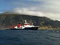
The town has a small harbour with berths accessible by small vessels only.
Gallery[]


Art[]
Graphic artist Rolf Weijburg produced an etch of Edinburgh of the Seven Seas[12] and other places on the island of Tristan da Cunha.[13]
Local government[]
The island's local affairs are managed by the Island Council, a 14-member administration that meets six times a year and is elected every three years.[14]
Government services[]
The town is home to the island's emergency services, which comprise one ambulance (a Toyota Hilux operated by Camogli Hospital), one fire engine (a Land Rover Defender with a small ladder) and one police car (Land Rover Series).[10]
The town administration also has a vehicle for official use.[10]
Places of interest and attractions[]
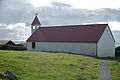
Most buildings in town are single story, with the largest being the factory and the tallest being St Joseph's Church.
- St. Mary's Anglican Church – built 1923[15]
- St. Joseph Catholic Church – built 1995–96 and replaced earlier church from 1983[15]
- St Mary's School – built 1975[16]
- Camogli Hospital – built in 1971 to replace Station Hospital (c. 1940s)[17]
- – built 1967[18]
- Prince Philip Hall and the Albatross Bar
- Tristan Thatched House Museum
- Agriculture Department warehouse
- Tristan Island Store – only supermarket on the island[19]
- Tristan Post Office, Tourism Centre and Café da Cunha – opened 2009[19]
- Administration Building – home to Island Council
- Crayfish Canning Factory – built 1963[20]
- Park 61 – volcanic park site
- The Patches – an area with potato farms have been used for over 150 years. In the area are camping huts.[21]
Notable people[]
- William Glass (1786-1853), founder of the settlement
- Conrad Glass (b. 1961), police officer
References[]
- ^ Saint Helena Independent Archived 20 July 2011 at the Wayback Machine 25 March 2011 p. 3
- ^ "Tristan da Cunha Settlement of Edinburgh of the Seven Seas". Retrieved 30 January 2016.
- ^ Courtney, Nicholas (2004). The Queen's Stamps. ISBN 0-413-77228-4, page 28. The visit took place during the circumnavigation the Duke of Edinburgh did while commanding HMS Galatea. Tristan da Cunha post office issued four stamps in 1967 to celebrate the centenary of this visit.
- ^ "Tristan da Cunha's Calshot Harbour". Retrieved 30 January 2016.
- ^ "South Africa: Tristan Da Cunha". March 2012. Archived from the original on 26 April 2015.
- ^ "Tristan Da Cunha Climate Guide to the Average Weather & Temperatures with Graphs Elucidating Sunshine and Rainfall Data & Information about Wind Speeds & Humidity". March 2012. Archived from the original on 17 November 2011.
- ^ "Tristan da Cunha's Climate".
- ^ "Tristan da Cunha Visitor Excursions". Retrieved 30 January 2016.
- ^ "The Tristan Times Newspaper – News from Tristan da Cunha". Archived from the original on 31 October 2014. Retrieved 30 January 2016.
- ^ Jump up to: a b c "Tristan da Cunha Land Transport News". Retrieved 30 January 2016.
- ^ "Olav's Tristanian number plates – Photographed in Tristan da Cunha". Retrieved 30 January 2016.
- ^ http://www.weijburg.nl/portofolio/etsen/116v.jpg
- ^ Rolf Weijburg’s website: http://www.weijburg.nl
- ^ "Archived copy" (PDF). Archived from the original (PDF) on 14 January 2014. Retrieved 15 August 2013.CS1 maint: archived copy as title (link)
- ^ Jump up to: a b "Tristan Churches". Retrieved 30 January 2016.
- ^ "Tristan School". Retrieved 30 January 2016.
- ^ "Camogli Hospital Tristan da Cunha". Retrieved 30 January 2016.
- ^ "Tristan da Cunha's Calshot Harbour". Retrieved 30 January 2016.
- ^ Jump up to: a b "Tristan da Cunha Shops".
- ^ "Tristan Fishing". Retrieved 30 January 2016.
- ^ "Tristan da Cunha Patches Plain". www.tristandc.com. Retrieved 24 July 2020.
External links[]
| show Authority control |
|---|
- Tristan da Cunha
- Populated places established in 1816
- Populated places in Saint Helena, Ascension and Tristan da Cunha
- 1816 establishments in the British Empire
- 1816 establishments in Africa