Eggenthal
Eggenthal | |
|---|---|
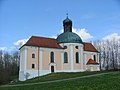
 Eggenthal, church | |
 Coat of arms | |
show Location of Eggenthal within Ostallgäu district | |
 Eggenthal | |
| Coordinates: 47°55′N 10°31′E / 47.917°N 10.517°ECoordinates: 47°55′N 10°31′E / 47.917°N 10.517°E | |
| Country | Germany |
| State | Bavaria |
| Admin. region | Schwaben |
| District | Ostallgäu |
| Government | |
| • Mayor (2020–26) | Karina Fischer[1] |
| Area | |
| • Total | 28.10 km2 (10.85 sq mi) |
| Elevation | 713 m (2,339 ft) |
| Population (2020-12-31)[2] | |
| • Total | 1,372 |
| • Density | 49/km2 (130/sq mi) |
| Time zone | UTC+01:00 (CET) |
| • Summer (DST) | UTC+02:00 (CEST) |
| Postal codes | 87653 |
| Dialling codes | 08347 |
| Vehicle registration | OAL |
| Website | www.eggenthal.de |


Eggenthal is a municipality in the district of Ostallgäu in Bavaria in Germany. It is located in the Allgäu region.
There are the Gemarkungs Bayersried and Eggenthal. There are also the villages of Romatsried and Holzstetten as well as several small hamlets. In Romatsried you will find the Burgstall Romatsried, a place that may have already been populated in the Bronze Age.
Sights[]

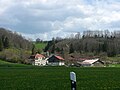
Bayersried from east

Eggenthal from southeast

Kreuzweg
Maria-Seelenkapelle (chapel)
Schleifmühle
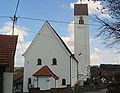
St. Afra


Notable people[]
- Michael Bredl (1916–1999)
References[]
- Eggenthal: Official statistics compiled by the Bavarian State Office of Statistics (LfStat) (PDF; 1,05 MB)
- ^ Liste der ersten Bürgermeister/Oberbürgermeister in kreisangehörigen Gemeinden, Bayerisches Landesamt für Statistik, 15 July 2021.
- ^ "Tabellenblatt "Daten 2", Statistischer Bericht A1200C 202041 Einwohnerzahlen der Gemeinden, Kreise und Regierungsbezirke". Bayerisches Landesamt für Statistik (in German). June 2021.
External links[]
| Wikimedia Commons has media related to Eggenthal. |
| Authority control |
|---|
This Ostallgäu location article is a stub. You can help Wikipedia by . |
Categories:
- Municipalities in Bavaria
- Ostallgäu
- Swabia (Bavaria) geography stubs