Mauerstetten
Mauerstetten | |
|---|---|
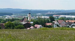 Mauerstetten seen from the east | |
 Coat of arms | |
show Location of Mauerstetten within Ostallgäu district | |
 Mauerstetten | |
| Coordinates: 47°53′N 10°40′E / 47.883°N 10.667°ECoordinates: 47°53′N 10°40′E / 47.883°N 10.667°E | |
| Country | Germany |
| State | Bavaria |
| Admin. region | Schwaben |
| District | Ostallgäu |
| Government | |
| • Mayor (2020–26) | Armin Holderried[1] |
| Area | |
| • Total | 16.55 km2 (6.39 sq mi) |
| Elevation | 716 m (2,349 ft) |
| Population (2020-12-31)[2] | |
| • Total | 3,153 |
| • Density | 190/km2 (490/sq mi) |
| Time zone | UTC+01:00 (CET) |
| • Summer (DST) | UTC+02:00 (CEST) |
| Postal codes | 87665 |
| Dialling codes | 08341 |
| Vehicle registration | OAL |
| Website | www.mauerstetten.de |


Mauerstetten is a municipality in the district of Ostallgäu in the southwest of Bavaria in Germany.
Its foundations dates back to the early 9th century, and its name actually means "place of walls", due to ruins of supposedly Roman origin found there. Currently, Mauerstetten has about 2,800 inhabitants living in the four parts of the community: Mauerstetten itself, Steinholz, Hausen and Frankenried. Agriculture still plays a large role in the village, but some modest industry is to be found there as well.
The village has a primary school, a kindergarten, two banks (Sparkasse and RaiBa), a small grocery store, a bakery, and a small post office. In the center of Mauerstetten stands the church St. Vitus.
References[]
- ^ Liste der ersten Bürgermeister/Oberbürgermeister in kreisangehörigen Gemeinden, Bayerisches Landesamt für Statistik, 15 July 2021.
- ^ "Tabellenblatt "Daten 2", Statistischer Bericht A1200C 202041 Einwohnerzahlen der Gemeinden, Kreise und Regierungsbezirke". Bayerisches Landesamt für Statistik (in German). June 2021.
External links[]
| Authority control |
|---|
This Ostallgäu location article is a stub. You can help Wikipedia by . |
- Municipalities in Bavaria
- Ostallgäu
- Swabia (Bavaria) geography stubs