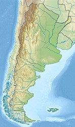
El Chaltén
El Chaltén | |
|---|---|
 El Chaltén | |
 Flag  Coat of arms | |
 El Chaltén | |
| Coordinates: 49°19′53.069″S 72°53′10.064″W / 49.33140806°S 72.88612889°WCoordinates: 49°19′53.069″S 72°53′10.064″W / 49.33140806°S 72.88612889°W | |
| Country | |
| Elevation | 410 metre m (410 metre ft) |
| Population (2010) | |
| • Total | 1,627 |

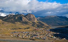
El Chaltén is a small mountain village in Santa Cruz Province, Argentina. It is located on the riverside of Rio de las Vueltas, within the Los Glaciares National Park (section Reserva Nacional Zona Viedma) near the base of Cerro Torre and Cerro Fitz Roy spires, both popular for climbing. It is 220 km north of El Calafate. It is also a popular base for hiking numerous trails, such as those to the base of surrounding peaks and glacial lakes, such as Laguna Torre and Laguna de los Tres (near the base of Fitz Roy).[1][2][3]
For those reasons, El Chaltén was named Argentina's Trekking Capital or Capital Nacional del Trekking. Today the sole reason for its existence is tourism. In 1985, Argentina and Chile had a border dispute to gain and claim rights over El Chalten. There was no war in the end, and El Chalten was awarded to Argentina. Homes, government buildings, and flags of Argentina went up to mark the city settlement.[4]
The town is located at the edge of the 12,363 km2 (4,773 sq mi) Southern Patagonian Ice Field and about 350 inhabitants live there throughout all the seasons of the year. Snow and ice mostly fence the town, and the homes are low structured with roads mostly made of rocks and dirt.[4] In October 2014, El Chalten took second place in a ranking of "Best cities in the world to know" of the travel guide Lonely Planet publishing in 2015, being the first city of Argentina.
Etymology[]
"Chaltén" is a Tehuelche word meaning smoking mountain, as they believe it was a volcano for its peak is most of the time covered by clouds. Other visited tracks and sights are Torre Glacier, Laguna Capri, Piedras Blancas Glacier, Chorrillo del Salto, and Laguna de los Tres.
In 1877, Argentine explorer Francisco Moreno named mount Chaltén as mount Fitz Roy, in honour of Robert FitzRoy, captain during the Second voyage of HMS Beagle in the 1830s. Mount Chaltén/Fitz Roy makes the town worth visiting because one can seek the impressive peaks from any area. The whole village finds a gorgeous view that keeps expanding due to the tourism and beautiful location.[5]
Tourism[]

The village provides national park information for visitors, as well as commercial camping (with showers) and a very limited number of beds, catering mostly for backpackers. The most popular hostel in town is La Comarca, located in front of the bus terminal. On the treks outside of the village free campsites are provided and reservations for campsites are not necessary. Some may train for expedition hikes, visit the glaciers, or raft along the rivers. There is currently one automated teller machine, and there is a bank. ( Banco de la Nacion Argentina )
The number of tourists seems to double each year. Most are people from another country who enjoy climbing mountains, seeing the magnificent Glacier National Park, and most importantly hiking. El Chalten has enormous amounts of trails to explore and take adventures, which makes it the national capital for hiking. South of the Tumbado Mountain, there are hiking trails up to Viento and Lagoon Toro. However, about 100-altitude meters overhead of El Chalten, there are also cliffs with large curves that look out on Condores. There are also high winds that occur often which makes it very dangerous for tourist to hike trails or climb mountains.[clarification needed][6]

The tourist trade has spawned a few restaurants, bars, supermarkets and shops in town, with a large variety of outdoor equipment for sale, while some of the accommodations provide internet and phone access and show regular movies. Other than that, the town is fairly far removed from the normal flow of news and communication, even during high season (November–February). The town is nearly deserted during the off-season (the southern hemisphere winter).
Climate[]
El Chaltén has the rare subantarctic continental climate (Köppen Dfc) with subpolar oceanic (Cfc) influences, which is only found at the higher elevations of the Southern Andes and the steppe to the east. Precipitation is at around 820 millimetres (32 in), distributed on a large number of days despite not being nearly as heavy as in Chilean Patagonia; bad weather is exceedingly common. Due to the town being situated in a valley, with the adjacent Fitz Roy massif and the Southern Patagonian Ice Field to the west, the weather can be very unpredictable, with four seasons in a single day being common. Thus, the temperature and weather can vary abruptly during the same day (although the large Viedma Lake to the south partially moderates the town's extremes). Summers experience up to 16 hours of daylight, very windy weather, and cool temperatures, mostly below 18 °C (64 °F) during the day and 7 °C (45 °F) during the night. Day time highs rarely exceed 25 °C (77 °F). Frost can and does occur in the summer too.
Winters bring snow in moderate quantities, and average temperatures around 4 °C (39 °F) during the day and −4 °C (25 °F) during the night; however, the coldest nights are much colder than this, usually below −12 °C (10 °F). Sunlight hours are reduced to just under 8, and while still windy, it is the calmest season of the year. Spring is the driest season, while fall is the wettest. Both are variable, but generally cold as well. The mean annual temperature is 6 °C (43 °F), making El Chaltén one of the coldest towns in Argentina.
The highest temperature recorded was 31.6 °C (88.9 °F) on February 20, 2003. The lowest recorded temperature was −20.2 °C (−4.4 °F) on June 24, 1944. The warmest month on record is January 2013, with a mean temperature of 14.1 °C (57.4 °F). The coldest is July 1982, with a mean temperature of −4.3 °C (24.3 °F).
| hideClimate data for El Chaltén (previoulsy Cerro Fitz Roy) 1991–2020 normals, extremes 1941-present | |||||||||||||
|---|---|---|---|---|---|---|---|---|---|---|---|---|---|
| Month | Jan | Feb | Mar | Apr | May | Jun | Jul | Aug | Sep | Oct | Nov | Dec | Year |
| Record high °C (°F) | 30.3 (86.5) |
31.6 (88.9) |
27.2 (81.0) |
23.8 (74.8) |
20.4 (68.7) |
19.9 (67.8) |
17.5 (63.5) |
17.6 (63.7) |
21.2 (70.2) |
22.5 (72.5) |
25.2 (77.4) |
28.8 (83.8) |
31.6 (88.9) |
| Average high °C (°F) | 17.4 (63.3) |
16.6 (61.9) |
14.8 (58.6) |
11.5 (52.7) |
6.6 (43.9) |
4.0 (39.2) |
4.0 (39.2) |
4.7 (40.5) |
7.6 (45.7) |
11.6 (52.9) |
13.9 (57.0) |
15.8 (60.4) |
10.7 (51.3) |
| Daily mean °C (°F) | 12.2 (54.0) |
11.6 (52.9) |
9.8 (49.6) |
6.6 (43.9) |
2.3 (36.1) |
−0.1 (31.8) |
−0.2 (31.6) |
0.1 (32.2) |
3.1 (37.6) |
6.8 (44.2) |
9.0 (48.2) |
11.0 (51.8) |
6.0 (42.8) |
| Average low °C (°F) | 7.0 (44.6) |
6.7 (44.1) |
4.9 (40.8) |
1.7 (35.1) |
−1.9 (28.6) |
−4.3 (24.3) |
−4.4 (24.1) |
−4.6 (23.7) |
−1.3 (29.7) |
1.9 (35.4) |
4.0 (39.2) |
6.3 (43.3) |
1.3 (34.3) |
| Record low °C (°F) | −3.8 (25.2) |
−2.9 (26.8) |
−5.9 (21.4) |
−13.0 (8.6) |
−14.7 (5.5) |
−20.2 (−4.4) |
−20.0 (−4.0) |
−18.5 (−1.3) |
−14.1 (6.6) |
−11.3 (11.7) |
−8.2 (17.2) |
−2.0 (28.4) |
−20.2 (−4.4) |
| Average precipitation mm (inches) | 50.1 (1.97) |
66.4 (2.61) |
77.5 (3.05) |
103.5 (4.07) |
86.1 (3.39) |
87.3 (3.44) |
68.9 (2.71) |
76.4 (3.01) |
46.9 (1.85) |
60.6 (2.39) |
48.6 (1.91) |
47.0 (1.85) |
819.4 (32.26) |
| Source 1: Red Hidrológica Nacional[7] | |||||||||||||
| Source 2: Sistema de Clasificación Bioclimática Mundial (extremes 1941-1950)[8] | |||||||||||||
Gallery[]

References[]
- ^ "Laguna Torre | Full Day Trek | Excursions and Services in El Chaltén offered by Walk Patagonia". www.walkpatagonia.com. Retrieved 9 October 2016.
- ^ "Laguna Torre - Self-guided treks in El Chaltén - elchalten.com, since 1999 showing El Chaltén to the world". www.elchalten.com. Retrieved 9 October 2016.
- ^ "Laguna de los Tres Hike". backpackers-review.com. Retrieved 5 March 2019.
- ^ Jump up to: a b "Best of Argentina". Patagonia-Argentina.com. Retrieved 3 December 2017.
- ^ "Best of Argentina". Patagonia-Argentina.com. Retrieved 3 December 2017.
- ^ "Best of Argentina". patagonia-argentina.com. Retrieved 3 December 2017.
- ^ "Sistema Nacional de Información Hídrica - Base de Datos (2840 - Chaltén)" (in Spanish). Secretaría de Infraestructura y Política Hídrica de la Nación (Argentina). Retrieved April 1, 2021.
- ^ "Cerro Fitz Roy (Argentina)" (PDF). Centro de Investigaciones Fitosociológicas. Retrieved January 31, 2016.
External links[]
| Wikimedia Commons has media related to El Chaltén. |
| Wikivoyage has a travel guide for El Chalten. |
| Authority control |
|
|---|
- Populated places in Santa Cruz Province, Argentina