El Cinco, San Juan, Puerto Rico
El Cinco | |
|---|---|
 Tren Urbano in El Cinco | |
 Location of El Cinco shown in yellow | |
| Coordinates: 18°23′29″N 66°03′45″W / 18.391275°N 66.062415°WCoordinates: 18°23′29″N 66°03′45″W / 18.391275°N 66.062415°W[1] | |
| Commonwealth | |
| Municipality | |
| Area | |
| • Total | 1.35 sq mi (3.5 km2) |
| • Land | 1.34 sq mi (3.5 km2) |
| • Water | 0.01 sq mi (0.03 km2) |
| Elevation | 66 ft (20 m) |
| Population (2010) | |
| • Total | 6,198 |
| • Density | 4,625.4/sq mi (1,785.9/km2) |
| 2010 census | |

El Cinco (Spanish for The Five) is one of the 18 barrios of the municipality of San Juan, Puerto Rico and a former barrio of the dissolved municipality of Rio Piedras. As of the 2010 United States Census, it had a population of 6,198 and a land area of 1.34 square miles (3.5 km2) resulting in a population density of 4,625.4/sq mi (1,785.9/km2).[3]
Geography[]
| Historical population | |||
|---|---|---|---|
| Census | Pop. | %± | |
| 1980 | 8,043 | — | |
| 1990 | 8,426 | 4.8% | |
| 2000 | 7,149 | −15.2% | |
| 2010 | 6,198 | −13.3% | |
| U.S. Decennial Census[4] 1899 (shown as 1900)[5] 1910-1930[6] 1930-1950[7] 1980-2000[8] 2010[9] | |||
El Cinco is surrounded by seven barrios: Gobernador Piñero, Monacillo Urbano, Monacillo, Cupey, Sabana Llana Sur, Río Piedras (pueblo) and Hato Rey Sur.
Landmarks and historic sites[]
This barrio is home to numerous sites listed in the US National Register of Historic Places. The historic , also known as the San Juan Historic Aqueduct, is an old aqueduct and water filtration plant that dates from 1846. The site is now listed in the National Register of Historic Places since 2007.[10] Other historic sites located in El Cinco are the , shared with Hato Rey Sur and dating from 1853, the Rum Pilot Plant located University of Puerto Rico Experimental Agricultural Station,[11] and the San Juan Botanical Garden is located nearby too.
Transportation[]
The area is served by the Tren Urbano metro system with the elevated Cupey station is located on the intersection of highways PR-1 and PR-176 in El Cinco. Despite the name of the station, it is not located in the barrio of Cupey, although it is indeed located nearby.
Gallery[]

Ruins of the historic aqueduct of Rio Piedras.
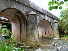
Historical Rio Piedras Bridge.
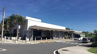
Cupey Station entrance.


See also[]
References[]
- ^ a b "US Gazetteer 2019". US Census. US Government.
- ^ U.S. Geological Survey Geographic Names Information System: El Cinco barrio
- ^ Puerto Rico:2010:population and housing unit counts.pdf (PDF). U.S. Dept. of Commerce, Economics and Statistics Administration, U.S. Census Bureau. 2010. p. 32.
- ^ "U.S. Decennial Census". United States Census Bureau. Archived from the original on February 13, 2020. Retrieved September 21, 2017.
- ^ "Report of the Census of Porto Rico 1899". War Department Office Director Census of Porto Rico. Archived from the original on July 16, 2017. Retrieved September 21, 2017.
- ^ "Table 3-Population of Municipalities: 1930 1920 and 1910" (PDF). United States Census Bureau. Archived (PDF) from the original on August 17, 2017. Retrieved September 21, 2017.
- ^ "Table 4-Area and Population of Municipalities Urban and Rural: 1930 to 1950" (PDF). United States Census Bureau. Archived (PDF) from the original on August 30, 2015. Retrieved September 21, 2014.
- ^ "Table 2 Population and Housing Units: 1960 to 2000" (PDF). United States Census Bureau. Archived (PDF) from the original on July 24, 2017. Retrieved September 21, 2017.
- ^ Puerto Rico:2010:population and housing unit counts.pdf (PDF). U.S. Dept. of Commerce Economics and Statistics Administration U.S. Census Bureau. 2010. Archived (PDF) from the original on 2017-02-20. Retrieved 2019-08-02.
- ^ "Antiguo Acueducto del Río Piedras | National Trust for Historic Preservation". savingplaces.org. Retrieved 2021-10-14.
- ^ , Wikipedia, 2021-05-23, retrieved 2021-10-14
| Barrios |
| |
|---|---|---|
This San Juan, Puerto Rico location article is a stub. You can help Wikipedia by . |
- Río Piedras, Puerto Rico
- Barrios of San Juan, Puerto Rico
- Puerto Rico Senatorial district I geography stubs