Quebrada Arenas, San Juan, Puerto Rico
Quebrada Arenas | |
|---|---|
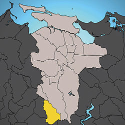 Location of Quebrada Arenas shown in yellow. | |
| Coordinates: 18°19′13″N 66°04′52″W / 18.320204°N 66.081249°WCoordinates: 18°19′13″N 66°04′52″W / 18.320204°N 66.081249°W[1] | |
| Commonwealth | |
| Municipality | |
| Area | |
| • Total | 2.46 sq mi (6.4 km2) |
| • Land | 2.46 sq mi (6.4 km2) |
| • Water | 0 sq mi (0 km2) |
| Elevation | 446 ft (136 m) |
| Population (2010) | |
| • Total | 2,747 |
| • Density | 1,116.7/sq mi (431.2/km2) |
| 2010 census | |
| Time zone | UTC−4 (AST) |

Quebrada Arenas (Spanish for sandy creek) is one of the 18 barrios of the municipality of San Juan, Puerto Rico. Located in the southwest corner of San Juan, it is the only rural barrio in the municipality. Quebrada Arenas is totally outside San Juan's municipal urban zone according to the last census. In 2010 it had a population of 2,747 and a land area of 2.46 square miles (6.4 km2), resulting in a population density of 1,116.7 residents per square mile (431.2 km2), the lowest of any barrio in San Juan.[3]
Quebrada Arenas has boundaries with the municipalities of Aguas Buenas and Caguas to the south, and Guaynabo to the west, and is bounded by Caimito barrios to the east and Tortugo barrio to the north.
Demographics[]
| Historical population | |||
|---|---|---|---|
| Census | Pop. | %± | |
| 1980 | 1,590 | — | |
| 1990 | 2,762 | 73.7% | |
| 2000 | 2,753 | −0.3% | |
| 2010 | 2,747 | −0.2% | |
| U.S. Decennial Census[4] 1899 (shown as 1900)[5] 1910-1930[6] 1930-1950[7] 1980-2000[8] 2010[9] | |||
See also[]
References[]
- ^ a b "US Gazetteer 2019". US Census. US Government.
- ^ U.S. Geological Survey Geographic Names Information System: Quebrada Arenas barrio
- ^ Puerto Rico:2010:population and housing unit counts.pdf (PDF). U.S. Dept. of Commerce, Economics and Statistics Administration, U.S. Census Bureau. 2010. p. 32.
- ^ "U.S. Decennial Census". United States Census Bureau. Archived from the original on February 13, 2020. Retrieved September 21, 2017.
- ^ "Report of the Census of Porto Rico 1899". War Department Office Director Census of Porto Rico. Archived from the original on July 16, 2017. Retrieved September 21, 2017.
- ^ "Table 3-Population of Municipalities: 1930 1920 and 1910" (PDF). United States Census Bureau. Archived (PDF) from the original on August 17, 2017. Retrieved September 21, 2017.
- ^ "Table 4-Area and Population of Municipalities Urban and Rural: 1930 to 1950" (PDF). United States Census Bureau. Archived (PDF) from the original on August 30, 2015. Retrieved September 21, 2014.
- ^ "Table 2 Population and Housing Units: 1960 to 2000" (PDF). United States Census Bureau. Archived (PDF) from the original on July 24, 2017. Retrieved September 21, 2017.
- ^ Puerto Rico:2010:population and housing unit counts.pdf (PDF). U.S. Dept. of Commerce Economics and Statistics Administration U.S. Census Bureau. 2010. Archived (PDF) from the original on 2017-02-20. Retrieved 2019-08-02.
| Barrios |
| |
|---|---|---|
This San Juan, Puerto Rico location article is a stub. You can help Wikipedia by . |
- Río Piedras, Puerto Rico
- Barrios of San Juan, Puerto Rico
- Puerto Rico Senatorial district I geography stubs