Elamville, Alabama
Elamville, Alabama | |
|---|---|
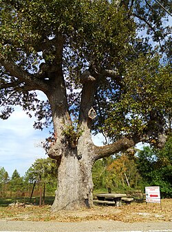 The "Old Oak Tree" | |
 Elamville, Alabama | |
| Coordinates: 31°40′04″N 85°39′23″W / 31.66778°N 85.65639°WCoordinates: 31°40′04″N 85°39′23″W / 31.66778°N 85.65639°W | |
| Country | United States |
| State | Alabama |
| County | Barbour |
| Elevation | 522 ft (159 m) |
| Time zone | UTC-6 (Central (CST)) |
| • Summer (DST) | UTC-5 (CDT) |
| Area code(s) | 334 |
| GNIS feature ID | 117907[1] |


Elamville is an unincorporated community in the southwest corner of Barbour County, Alabama, United States. In the early to mid-20th century Elamville was known for the "Old Oak Tree" in the middle of town where the elderly men of the community played dominoes on the state- provided concrete picnic table.
History[]
Elamville was named after a local church, Elam Church, which itself was named for the ancient kingdom of Elam.[2]
References[]
- ^ "Elamville". Geographic Names Information System. United States Geological Survey.
- ^ Foscue, Virginia (1989). Place Names in Alabama. Tuscaloosa: The University of Alabama Press. p. 51. ISBN 0-8173-0410-X.
Municipalities and communities of Barbour County, Alabama, United States | ||
|---|---|---|
| Cities |  | |
| Towns | ||
| Unincorporated communities | ||
| ||
This Barbour County, Alabama state location article is a stub. You can help Wikipedia by . |
Categories:
- Unincorporated communities in Alabama
- Unincorporated communities in Barbour County, Alabama
- South Alabama geography stubs