Elderberry Forebay Dam
| Elderberry Forebay Dam | |
|---|---|
| Location | Los Angeles County, California |
| Coordinates | 34°33′43″N 118°37′51″W / 34.56194°N 118.63083°WCoordinates: 34°33′43″N 118°37′51″W / 34.56194°N 118.63083°W |
| Opening date | 1974 |
| Dam and spillways | |
| Type of dam | Earthfill[1] |
| Impounds | Castaic Creek |
| Height | 179 ft (55 m)[1] |
| Length | 1,935 ft (590 m)[1] |
| Elevation at crest | 1,550 ft (470 m)[1] |
| Width (base) | 25 ft (7.6 m)[1] |
| Dam volume | 5,896,950 cu yd (4,508,540 m3)[1] |
| Reservoir | |
| Creates | Elderberry Forebay |
| Total capacity | 28,400 acre⋅ft (35,000 dam3)[1] |
| Catchment area | 81.6 sq mi (211 km2)[1] |
| Surface area | 450 acres (180 ha)[1] |
| Normal elevation | 1,519 ft (463 m)[2] |

Elderberry Forebay Dam is a dam located in the Sierra Pelona Mountains of northwestern Los Angeles County, California. The dam partitions Elderberry Forebay from Castaic Lake. It forms the headwater reservoir for Castaic Power Plant, a pumped-storage hydroelectricity generation facility.[1][3] The dam was completed in 1974 as part of the California State Water Project.
See also[]
References[]
- ^ a b c d e f g h i j "Dams Within the Jurisdiction of the State of California (A-G)" (PDF). California Department of Water Resources, Division of Safety of Dams. Retrieved November 1, 2013.
- ^ "Elderberry Forebay". Geographic Names Information System. United States Geological Survey.
- ^ "Castaic Lake" (PDF). California Department of Water Resources. Retrieved November 1, 2013.
Dams in Los Angeles County, California | ||
|---|---|---|
| CA Department of Water Resources | 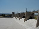 | |
| LA Department of Public Works |
| |
| LA Department of Water and Power |
| |
| US Army Corps of Engineers | ||
| Other |
| |
Categories:
- Dams in Los Angeles County, California
- California Department of Water Resources dams
- California State Water Project
- Earth-filled dams
- Sierra Pelona Ridge
- Dams completed in 1974