Electoral district of North Melbourne
| North Melbourne Victoria—Legislative Assembly | |
|---|---|
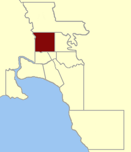 Location within Greater Melbourne area, 1859 | |
| State | Victoria |
| Created | 1859 |
| Abolished | 1927 |
| Demographic | Metropolitan |
North Melbourne was an electoral district of the Legislative Assembly[1] in the Australian state of Victoria from 1859[2] to 1927.
The Electoral District of North Melbourne was defined as being bound by Victoria Street/Parade on the south, Nicholson Street on the east, the southern boundary of portion 90, parish of Jika Jika on the north and a line south from Mains Bridge (now Flemington Bridge)[3] to the Victoria Street alignment by the 1858 Electoral Districts Act.[2] This included the suburbs of Carlton, Parkville and North Melbourne.
The district was abolished, along with several others, when the Electoral Districts Act 1926[4] was implemented in 1927.
Members[]
Two members initially,[2] one from the redistribution of 1889 when Port Melbourne and other districts were created.[1]
| Member 1 | Term | Member 2 | Term |
|---|---|---|---|
| Oct 1859 – Jul 1861 | George Elliott Barton | Oct 1859 – Jul? 1861 | |
| Patrick Costello | Aug 1861 – Nov 1861[x] | Aug 1861 – Aug 1864 | |
| Nov 1861[5]– Aug 1864 | |||
| Nov 1864 – Mar 1874 | Nov 1864 – Dec 1865 | ||
| Feb 1866 – Jan 1871 | |||
| James Munro | May 1874 – Apr 1877 | Apr 1871 – Apr 1877 | |
| May 1877 – Apr 1892 | May 1877 – Mar 1881 | ||
| James Munro | Apr 1881[b] – Feb 1883 | ||
| James Rose | Feb 1883 – Mar 1889 | ||
| May 1892 – May 1893 | |||
| Jun 1893[b] – Sep 1894 | |||
| George Prendergast | Oct 1894 – Sep 1897 | ||
| William Watt | Oct 1897 – Oct 1900 | ||
| George Prendergast | Nov 1900 – Dec 1926 |
- b = by-election
- x = expelled
Prendergast went on to represent the Electoral district of Footscray, which was re-created in 1927.[1]
References[]
- ^ a b c "Re-Member (Former Members)". State Government of Victoria. Retrieved 2 May 2013.
- ^ a b c "An Act to alter the Electoral Districts of Victoria and to increase the number of Members of the Legislative Assembly thereof" (PDF). Australasian Legal Information Institute. 1858. Retrieved 2 May 2013.
- ^ "Moonee Valley Thematic Environmental History, p.50". Retrieved 2 May 2013.
- ^ "Electoral Districts Act 1926". Australasian Legal Information Institute. Retrieved 14 June 2013.
- ^ "Legislative Assembly". The Argus. Melbourne, Vic. 27 November 1861.
Coordinates: 37°47′57″S 144°56′48″E / 37.79917°S 144.94667°E
- Former electoral districts of Victoria (Australia)
- 1859 establishments in Australia
- 1927 disestablishments in Australia