Elkhorn Mountains (Oregon)
| Elkhorn Mountains | |
|---|---|
 | |
| Highest point | |
| Peak | Rock Creek Butte, Baker County |
| Elevation | 9,106 ft (2,776 m)[1] |
| Coordinates | 44°49′00″N 118°06′13″W / 44.81667°N 118.10361°W[2] |
| Geography | |
| Country | United States |
| State | Oregon |
| Counties | Baker, Grant, and Union[3] |
| Range coordinates | 44°52′20″N 118°11′34″W / 44.87222°N 118.19278°WCoordinates: 44°52′20″N 118°11′34″W / 44.87222°N 118.19278°W[3] |
| Topo map | USGS Bourne |


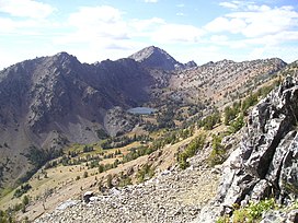
The Elkhorn Mountains are a mountain range, part of the Blue Mountains, in the northeastern part of Oregon in the United States.[3] The highest point in the range is Rock Creek Butte, which is 9,106 feet (2,776 m) above sea level.[1] The Elkhorn Mountains are partly within the Wallowa–Whitman National Forest and the North Fork John Day Wilderness.[1][4]
See also[]
References[]
- ^ a b c "Elkhorn Mountains (OR)". SummitPost.org. Retrieved September 24, 2014.
- ^ "Rock Creek Butte". Geographic Names Information System. United States Geological Survey. November 28, 1980. Retrieved September 24, 2014.
- ^ a b c d "Elkhorn Mountains". Geographic Names Information System. United States Geological Survey. May 16, 1997. Retrieved September 24, 2014.
- ^ "North Fork John Day Wilderness". Wilderness.net. Retrieved September 24, 2014.
External links[]
- Elkhorn Crest National Recreation Trail #1611: U.S. Forest Service
- Elkhorn Range from Hoffer Lakes near Anthony Lake: hiking guide by William Sullivan

A mountain goat in the Elkhorn Mountains
This Baker County, Oregon state location article is a stub. You can help Wikipedia by . |
This Grant County, Oregon state location article is a stub. You can help Wikipedia by . |
This Union County, Oregon state location article is a stub. You can help Wikipedia by . |
Categories:
- Mountain ranges of Oregon
- Mountain ranges of Baker County, Oregon
- Mountain ranges of Grant County, Oregon
- Landforms of Union County, Oregon
- Wallowa–Whitman National Forest
- Oregon geography stubs