Baker County, Oregon
Baker County | |
|---|---|
U.S. county | |
 Baker County Courthouse in Baker City | |
 Seal | |
 Location within the U.S. state of Oregon | |
 Oregon's location within the U.S. | |
| Coordinates: 44°43′N 117°40′W / 44.71°N 117.67°W | |
| Country | |
| State | |
| Founded | September 22, 1862 |
| Seat | Baker City |
| Largest city | Baker City |
| Area | |
| • Total | 3,088 sq mi (8,000 km2) |
| • Land | 3,068 sq mi (7,950 km2) |
| • Water | 20 sq mi (50 km2) 0.6% |
| Population (2010) | |
| • Total | 16,134 |
| • Estimate (2019) | 16,124 |
| • Density | 5.22/sq mi (2.02/km2) |
| Time zone | UTC−8 (Pacific) |
| • Summer (DST) | UTC−7 (PDT) |
| Congressional district | 2nd |
| Website | www |
Baker County is one of the 36 counties in the U.S. state of Oregon. As of the 2010 United States Census, the population was 16,134.[1] The county seat and largest city is Baker City.[2] The county was organized on September 22, 1862 when a portion of Wasco County was partitioned off. The new county's area was reduced in 1864 when Union County was partitioned off, and again in 1887 when Malheur County was partitioned off. The county's lines were last adjusted in 1901 when a parcel was added to the county.
Baker County was named for Edward Dickinson Baker, a senator from Oregon who was killed at Ball's Bluff, a battle of the Civil War in Virginia in 1861. The county is part of the county definition of Eastern Oregon.
History[]
The first groups from the eastern U.S. following the Oregon Trail passed through the area on their way to the Willamette Valley, unaware of the potential wealth they passed over. At Flagstaff Hill, near Baker City, 15 miles (24 km) of wagon ruts left by immigrants can still be seen.
The previous Oregon Territory had achieved statehood in 1859. In 1861 gold was discovered in eastern Wasco County, and a gold rush ensued; the area quickly became the Northwest's largest producer of gold. In September 1862 the state assembly created Baker County from Wasco. Later, Union County and Malheur County were created from this county. The boundaries were adjusted for the last time in 1901, when the area between the Powder River and the Wallowa Mountains was returned to Baker County. The original county seat was at Auburn. While at first a booming mining town with 5,000 inhabitants, once the gold was mined out Auburn's population dwindled, and county citizens voted in 1868 to make Baker City the new county seat. Baker City was incorporated in 1874.
The population of Baker County nearly quadrupled from 1880 to 1910, largely due to the Sumpter Valley Railroad and several of its spur lines, which helped lumber and mining operations to develop.[3]
In 1914 Fern Hobbs, on behalf of her employer Governor Oswald West, declared martial law in the Baker County city of Copperfield. This was the first declaration of martial law in the state since the American Civil War.
From 1915 through 1946, Baker County was represented in the Oregon State Senate by William H. Strayer. When he died in 1946, Strayer had served in the Oregon legislature longer then than any person in the state's history.[4]
Geography[]
According to the U.S. Census Bureau, the county has a total area of 3,088 square miles (8,000 km2), of which 3,068 square miles (7,950 km2) is land and 20 square miles (52 km2) (0.6%) is water.[5]
The terrain of Baker County is generally rugged, with 30% of the county covered with forest. The county's highest point is Red Mountain at around 9,560 feet ASL,[6][7] located 3 km from the county's northern line. The eastern boundary of the county is described by the northward-flowing Snake River, and the county terrain generally slopes to the Snake River's valley.[8]
Adjacent counties[]
- Union County - north
- Wallowa County - northeast
- Adams County, Idaho - east/Mountain Time Border
- Washington County, Idaho - southeast/Mountain Time Border
- Malheur County - south/Mountain Time Border
- Grant County - west
National protected areas[]
- Deer Flat National Wildlife Refuge (part)
- Hells Canyon National Recreation Area (part)
- Malheur National Forest (part)
- Whitman National Forest (part)
Demographics[]
| Historical population | |||
|---|---|---|---|
| Census | Pop. | %± | |
| 1870 | 2,804 | — | |
| 1880 | 4,616 | 64.6% | |
| 1890 | 6,764 | 46.5% | |
| 1900 | 15,597 | 130.6% | |
| 1910 | 18,076 | 15.9% | |
| 1920 | 17,929 | −0.8% | |
| 1930 | 16,754 | −6.6% | |
| 1940 | 18,297 | 9.2% | |
| 1950 | 16,175 | −11.6% | |
| 1960 | 17,295 | 6.9% | |
| 1970 | 14,919 | −13.7% | |
| 1980 | 16,134 | 8.1% | |
| 1990 | 15,317 | −5.1% | |
| 2000 | 16,741 | 9.3% | |
| 2010 | 16,134 | −3.6% | |
| 2019 (est.) | 16,124 | [9] | −0.1% |
| US Decennial Census[10] 1790-1960[11] 1900-1990[12] 1990-2000[13] 2010-2019[1] | |||
2000 census[]
As of the 2000 United States Census,[14] there were 16,741 people, 6,883 households, and 4,680 families in the county. The population density was 6/sqmi (2/km2). There were 8,402 housing units at an average density of 3/sqmi (1/km2). The racial makeup of the county was:
- 95.68% White
- 0.23% Black or African American
- 1.09% Native American
- 0.38% Asian
- 0.04% Pacific Islander
- 0.92% from other races
- 1.65% from two or more races.
2.34% of the population were Hispanic or Latino of any race. 18.4% were of English, 17.4% German, 11.4% American and 9.1% Irish ancestry.
There were 6,883 households, out of which 28.00% had children under the age of 18 living with them, 56.20% were married couples living together, 8.60% had a female householder with no husband present, and 32.00% were non-families. 27.80% of all households were made up of individuals, and 13.40% had someone living alone who was 65 years of age or older. The average household size was 2.37 and the average family size was 2.87.
The county population contained 24.20% under the age of 18, 5.80% from 18 to 24, 23.60% from 25 to 44, 27.30% from 45 to 64, and 19.00% who were 65 years of age or older. The median age was 43 years. For every 100 females there were 98.10 males. For every 100 females age 18 and over, there were 95.30 males.
The median income for a household in the county was $30,367, and the median income for a family was $36,106. Males had a median income of $27,133 versus $20,480 for females. The per capita income for the county was $15,612. About 10.10% of families and 14.70% of the population were below the poverty line, including 18.80% of those under age 18 and 12.40% of those age 65 or over.
2010 census[]
As of the 2010 United States Census, there were 16,134 people, 7,040 households, and 4,430 families residing in the county.[15] The population density was 5.3 inhabitants per square mile (2.0/km2). There were 8,826 housing units at an average density of 2.9 per square mile (1.1/km2).[16] The racial makeup of the county was 94.6% white, 1.1% American Indian, 0.5% Asian, 0.4% black or African American, 0.1% Pacific islander, 1.0% from other races, and 2.4% from two or more races. Those of Hispanic or Latino origin made up 3.3% of the population.[15] In terms of ancestry, 24.5% were German, 14.8% were Irish, 14.6% were English, and 8.1% were American.[17]
Of the 7,040 households, 24.4% had children under the age of 18 living with them, 50.7% were married couples living together, 8.3% had a female householder with no husband present, 37.1% were non-families, and 31.2% of all households were made up of individuals. The average household size was 2.24 and the average family size was 2.78. The median age was 47.9 years.[15]
The median income for a household in the county was $39,704 and the median income for a family was $50,507. Males had a median income of $43,849 versus $30,167 for females. The per capita income for the county was $21,683. About 12.7% of families and 19.9% of the population were below the poverty line, including 27.2% of those under age 18 and 10.6% of those age 65 or over.[18]
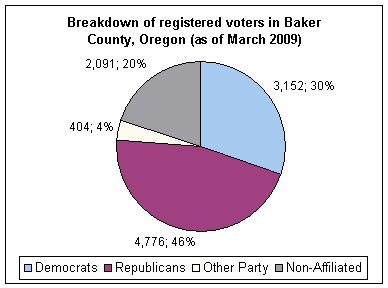
Politics[]
Like all counties in eastern Oregon, the majority of registered voters who are part of a political party in Baker County are members of the Republican Party. In the 2008 presidential election, 64.37% of Baker County voters voted for Republican John McCain, while 31.95% voted for Democrat Barack Obama and 3.66% of voters either voted for a Third Party candidate or wrote in a candidate.[19] These numbers have changed slightly from the 2004 presidential election, in which 69.2% voted for George W. Bush, while 29% voted for John Kerry, and 1.8% of voters either voted for a Third Party candidate or wrote in a candidate.[20]
Economy[]
Gold mining was the original impetus for settlement in the area, and at one time the county was the largest gold producer in the Northwest. Gold dredging was conducted with the Sumpter Valley Gold Dredge. With the exhaustion of the gold fields, agriculture, stock raising, logging became the primary economic pursuits. In the last decades of the 20th century, tourism also contributed to the local economy, helped by attractions such as Eagle Cap Wilderness Area, Hells Canyon National Recreation Area, and Anthony Lakes Ski Area. The National Historic Oregon Trail Interpretive Center opened in 1993.
Portions of Season 11 of Discovery's TV show Gold Rush was filmed in Baker County.[23]
Communities[]
Incorporated cities[]
- Baker City (county seat)
- Greenhorn
- Haines
- Halfway
- Huntington
- Richland
- Sumpter
- Unity
Unincorporated communities[]
Ghost towns[]
See also[]
Notes[]
- ^ The leading "other" candidate, Progressive Theodore Roosevelt, received 1,120 votes, while Socialist Eugene Debs received 469 votes, Prohibition candidate Eugene Chafin received 54 votes.
References[]
- ^ Jump up to: a b "State & County QuickFacts". US Census Bureau. Archived from the original on July 6, 2011. Retrieved November 14, 2013.
- ^ "Find a County". National Association of Counties. Archived from the original on May 31, 2011. Retrieved June 7, 2011.
- ^ William G. Robbins, Landscapes of Promise: The Oregon Story, 1800-1940. Seattle WA: University of Washington Press, 1997; p. 142.
- ^ Loew, Tracy and Jonathan Bach "Peter Courtney Keeps Senate Seat, Shattering Record for Longest Serving Oregon Legislator",Statesman Journal, Salem, Oregon, 6 November 2018.
- ^ "2010 Census Gazetteer Files". US Census Bureau. August 22, 2012. Retrieved February 25, 2015.
- ^ Red Mountain ID (peakbagger.com, accessed November 9, 2019)
- ^ "What's the Highest Point in each of Oregon's 36 Counties?" (oregonlive.com, accessed November 9, 2019)
- ^ "Baker County OR" (Google Maps, accessed November 9, 2019)
- ^ "Population and Housing Unit Estimates". Retrieved March 26, 2020.
- ^ "US Decennial Census". US Census Bureau. Retrieved February 25, 2015.
- ^ "Historical Census Browser". University of Virginia Library. Retrieved February 25, 2015.
- ^ Forstall, Richard L., ed. (March 27, 1995). "Population of Counties by Decennial Census: 1900 to 1990". US Census Bureau. Retrieved February 25, 2015.
- ^ "Census 2000 PHC-T-4. Ranking Tables for Counties: 1990 and 2000" (PDF). US Census Bureau. April 2, 2001. Retrieved February 25, 2015.
- ^ "U.S. Census website". US Census Bureau. Retrieved 31 January 2008.
- ^ Jump up to: a b c "Profile of General Population and Housing Characteristics: 2010 Demographic Profile Data". US Census Bureau. Archived from the original on February 13, 2020. Retrieved February 23, 2016.
- ^ "Population, Housing Units, Area, and Density: 2010 - County". US Census Bureau. Archived from the original on February 13, 2020. Retrieved February 23, 2016.
- ^ "Selected Social Characteristics in the US – 2006-2010 American Community Survey 5-Year Estimates". US Census Bureau. Archived from the original on February 13, 2020. Retrieved February 23, 2016.
- ^ "Selected Economic Characteristics – 2006-2010 American Community Survey 5-Year Estimates". US Census Bureau. Archived from the original on February 13, 2020. Retrieved February 23, 2016.
- ^ http://www1.bakercounty.org/EResults.nsf/electionresults11042008?OpenFrameset Retrieved on 4/21/09
- ^ "Baker County, Oregon detailed profile - houses, real estate, cost of living, wages, work, agriculture, ancestries, and more". www.city-data.com. Retrieved April 11, 2018.
- ^ "Oregon Secretary of State: Election Statistics". sos.oregon.gov. Retrieved 10 December 2018.
- ^ Leip, David. "Atlas of US Presidential Elections". uselectionatlas.org. Retrieved April 11, 2018.
- ^ Oregonian/OregonLive, Kristi Turnquist | The (2020-10-29). "Another Northwest miner joins 'Gold Rush,' looking for gold in Oregon". oregonlive. Retrieved 2021-03-03.
Further reading[]
- Baker County Historical Society, "The History of Baker County, Oregon. Portland OR: Baker County Historical Society, 1986.
- Eloise Dielman, Jon Croghan, and Gary Dielman, Baker County Links to the Past. Baker City OR: Baker County Historical Society, 2001.
- Gary Dielman, "Discovering Gold in Baker County Library's Photograph Collection," Oregon Historical Quarterly, vol. 109, no. 1 (Spring 2008).
- Ruth H. Evans, Centennial Pioneer Families of Baker County. n.c.: n.p., c. 1974.
- Isaac Hiatt, Thirty-one years in Baker County: A History of the County from 1861 to 1893. Baker OR: Baker County Historical Society, 1970.
- Gordon Stewart and Patricia Stewart, Baker County Sketch Book. n.c.: n.p., 1956.
- An Illustrated History of Baker, Grant, Malheur and Harney Counties, with a Brief Outline of the Early History of the State of Oregon. Chicago: Western Historical Publishing Company, 1902.
- Turnbull, George S. (1939). . . Binfords & Mort.
- The History of Baker County, Oregon, 1986. Portland OR: Baker County Historical Society, 1986.
External links[]
| show Municipalities and communities of Baker County, Oregon, United States |
|---|


- Oregon counties
- Baker County, Oregon
- 1862 establishments in Oregon
- Populated places established in 1862