Empshott


Empshott is a village in the East Hampshire district of Hampshire, England. It lies 3.5 miles (5.5 km) southwest of Bordon, its nearest town. It is included in the civil parish of Hawkley. The nearest railway station is 2.7 miles (4.4 km) southeast of the village, at Liss.
Geography[]
To the west the land rises steeply in a scarp formation known as the East Hampshire Hangars. Goleigh Hill (220 m) and Noar Hill (214 m) are two of the highest points in the county which forms parts of the Hampshire Downs. The River Rother has its source in the village.
History[]
Empshott is listed in the 1086 Domesday survey as being held by Geoffrey the Marshal, having been granted the land from pre-conquest landowners Bondi the Constable and Saxi of Clatford after 1066. The hamlet comprised four villagers and a mill.[1]
The famous Hambledon batsman John Small was born in Empshott in 1737.[2]
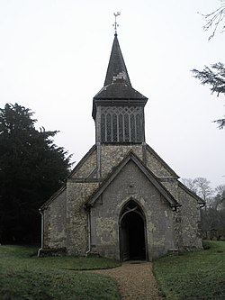
Church[]
The village is home to the Holy Rood church which dates to the 13th century.[3] Later additions include a Victorian bell-turret.[3]
References[]
- ^ "Open Domesday: Empshott". Retrieved 22 August 2021.
- ^ CricketArchive record of John Small
- ^ a b Pevsner, Nikolaus; LLoyd, David (1967). The Buildings of England Hampshire and the Isle of wight. Penguin Books. pp. 211–212. ISBN 0140710329.
External links[]
![]() Media related to Empshott at Wikimedia Commons
Media related to Empshott at Wikimedia Commons

This Hampshire location article is a stub. You can help Wikipedia by . |
- Villages in Hampshire
- Hampshire geography stubs