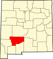
Engle, New Mexico
Engle | |
|---|---|
 Engle Location within the state of New Mexico | |
| Coordinates: 33°10′37″N 107°01′53″W / 33.17694°N 107.03139°WCoordinates: 33°10′37″N 107°01′53″W / 33.17694°N 107.03139°W | |
| Country | United States |
| State | New Mexico |
| County | Sierra |
| Elevation | 4,777 ft (1,456 m) |
| Time zone | UTC-7 (Mountain (MST)) |
| • Summer (DST) | UTC-6 (MDT) |
| ZIP code | 87935 |
| Area code(s) | 575 |
| GNIS feature ID | 888887[1] |
Engle is an unincorporated community in Sierra County, New Mexico.[1]
Engle was a station on the Atchison, Topeka and Santa Fe Railway and New Mexico State Road 51 passes through the community. Elephant Butte Reservoir and Truth or Consequences lie to the west and the San Andres Mountains are to the east.[2]
History[]
El Camino Real de Tierra Adentro passed through the vicinity of Engle; two former segments of the road near Engle are listed on the National Register of Historic Places.[3] West of Engle is Engle Lake originally known as the Laguna del Muerto (Lake of the Dead Man). It was a paraje, one of the few along this route through the Jornada del Muerto with reliable seasonal water and grass that grew on the lake bottom following the retreating waters of the evaporating lake. If the lake was dry, stock had to be driven to water at the spring Ojo del Muerto, six miles west in the Fra Cristobal Range.[4] : 155–157
Notable person[]
- Rudd Weatherwax, actor, was born in Engle.[5]
References[]
- ^ a b "Engle, New Mexico". Geographic Names Information System. United States Geological Survey.
- ^ Engle, NM and Sowell, NM 15 Minute Topographic Quadrangles, USGS, 1959
- ^ "Weekly List of Actions Taken On Properties: 2/13/12 Through 2/17/12". National Park Service. Retrieved December 9, 2014.
- ^ George D. Torok, From the Pass to the Pueblos, Sunstone Press, Santa Fe, Dec 1, 2011
- ^ IMBD-Rudd Weatherwax
External links[]
![]() Media related to Engle, New Mexico at Wikimedia Commons
Media related to Engle, New Mexico at Wikimedia Commons
- Unincorporated communities in Sierra County, New Mexico
- Unincorporated communities in New Mexico
- New Mexico geography stubs


