Escanaba River
| Escanaba River | |
|---|---|
 | |
| Location | |
| State | Michigan |
| Physical characteristics | |
| Source | |
| • location | Gwinn |
| Mouth | Lake Michigan |
| Length | 52.2 miles (84 km) |
| Basin size | 924 sq mi (2,390 km2) |
| Discharge | 676 cfs |
| Basin features | |
| Cities | Escanaba Gwinn |
The Escanaba River is a 52.2-mile-long (84.0 km)[1] river on the Upper Peninsula of the U.S. state of Michigan.
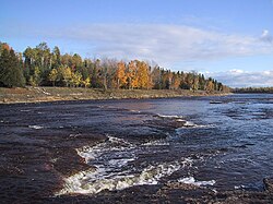
In his poem The Song of Hiawatha, Henry Wadsworth Longfellow describes how Hiawatha "crossed the rushing Esconaba". It is a wide river that cuts into limestone beds. The upper river is rocky and scenic and supports brook, brown and some rainbow trout throughout along with in the impoundments. John D. Voelker, writing as Robert Traver, authored fishing stories set on the Escanaba in Trout Madness.
The East Branch and the Middle Branch of the Escanaba converge in the town of Gwinn to form the main stem. The stretch from this convergence south to the Delta County line is mostly wide and smooth, ideal for a canoe trip. Dams on the river's branches require caution, however. From the Delta County line, the river runs south to its mouth on Lake Michigan at 45°46′37″N 87°03′30″W / 45.77694°N 87.05833°WCoordinates: 45°46′37″N 87°03′30″W / 45.77694°N 87.05833°W, near the city of Escanaba.
 WikiMiniAtlas
Geology[]
The Escanaba River watershed is one of the largest watersheds in Michigan’s Upper Peninsula totaling 924 square miles and has 508 miles of streams that flow year round. This watershed starts in west central Marquette County, north of Lake Michigan, and flows southeast to Lake Michigan at Little Bay de Noc. The name of this large river system and the community of Escanaba were derived from an Ojibwa (Chippewa) Indian word meaning “flat rock.” The majority of the limestone bedrock waterfalls found near Lake Michigan have been impounded for power generation and/or paper making.
References[]
- ^ U.S. Geological Survey. National Hydrography Dataset high-resolution flowline data. The National Map Archived 2012-03-29 at the Wayback Machine, accessed December 19, 2011
| Authority control |
|---|
This Delta County, Michigan location article is a stub. You can help Wikipedia by . |
- Rivers of Michigan
- Rivers of Delta County, Michigan
- Tributaries of Lake Michigan
- Upper Peninsula, Michigan geography stubs
- Michigan river stubs