Estellencs
Estellencs | |
|---|---|
 Estellencs | |
 Seal | |
 Mpa of Estelllencs in Mallorca | |
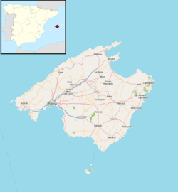 Estellencs Estellencs shown within Majorca | |
| Coordinates: 39°39′12″N 2°28′53″E / 39.65333°N 2.48139°ECoordinates: 39°39′12″N 2°28′53″E / 39.65333°N 2.48139°E | |
| Sovereign state | |
| Autonomous community | |
| Province | |
| Island | |
| Comarca | Serra de Tramuntana |
| Administrative HQ | Estellencs |
| Government | |
| • Type | Municipal corporation |
| • Body | Ajuntament d'Estellencs |
| • Mayor | Bartomeu Jover Sánchez (PP) |
| Area | |
| • Total | 13 km2 (5 sq mi) |
| Population (2018)[1] | |
| • Total | 318 |
| Time zone | UTC+1 (Central European Time) |
| • Summer (DST) | UTC+2 (Central European Summer Time) |
| Website | www.ajestellencs.net |


Estellencs is a municipality on the Spanish Balearic island of Majorca. The village of the same name is the administrative seat of the municipality. It borders the municipalities of Andratx, Calvià, Puigpunyent, and Banyalbufar.
It lies between the Tramuntana mountain range, on the slopes of Mount Galatzó (1,026 metres),[2] and the Mediterranean Sea.
References[]
- ^ Municipal Register of Spain 2018. National Statistics Institute.
- ^ "Mount Galatzó". Peakware.com. Archived from the original on 2016-03-04.
External links[]
| show Municipalities in the Balearic Islands |
|---|
| show Authority control |
|---|
This article about a location in the Balearic Islands is a stub. You can help Wikipedia by . |
Categories:
- Municipalities in Mallorca
- Populated places in Mallorca
- Balearic Islands geography stubs