Eton Urban District
Coordinates: 51°29′17″N 0°36′33″W / 51.4881°N 0.6092°W

| Eton | |
|---|---|
| Area | |
| • 1911 | 299 acres (1.2 km2) |
| • 1961 | 993 acres (4.0 km2) |
| Population | |
| • 1901 | 3,301 |
| • 1971 | 3,964 |
| History | |
| • Created | 1894 |
| • Abolished | 1974 |
| • Succeeded by | Windsor and Maidenhead DA |
| Status | Urban District |
Eton Urban District was from 1894 to 1974 a local government district in the administrative county of Buckinghamshire, England. In 1894 the urban district took over the responsibilities of the disbanded Eton Local Board District.
Between 1900 and 1934 the Eton civil parish incorporated parts of the neighbouring parishes of Eton Wick, Boveney, and Upton cum Chalvey as the town and population of Eton expanded rapidly.
In 1974, under the Local Government Act 1972 Eton UD was disbanded and together with parts of Eton Rural District was transferred to Berkshire and combined with adjacent urban districts to form Windsor and Maidenhead District.

Eton RD is the entity above around Slough ( Slough is tinted dark green), but not the small borough directly below it, which is Eton UD.
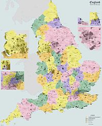
Administrative map of England in 1931.
References[]
| Ancient boroughs | |
|---|---|
| Incorporated boroughs | |
| Urban districts | |
| Rural districts | |
| Civil parishes | |
Categories:
- Districts of England created by the Local Government Act 1894
- Districts of England abolished by the Local Government Act 1972
- History of Buckinghamshire
- Local government in Buckinghamshire
- Urban districts of England