Eton Rural District
This article does not cite any sources. (December 2009) |
Coordinates: 51°29′17″N 0°36′33″W / 51.4881°N 0.6092°W

| Eton | |
|---|---|
| Area | |
| • 1911 | 41,005 acres (165.9 km2) |
| • 1961 | 35,537 acres (143.8 km2) |
| Population | |
| • 1901 | 20,038 |
| • 1971 | 72,035 |
| History | |
| • Created | 1894 |
| • Abolished | 1974 |
| • Succeeded by | South Bucks |
| Status | Rural district |
Eton was a rural district in the administrative county of Buckinghamshire, England. It was named after but did not contain Eton, which was an urban district.
It was created under the Local Government Act 1894 and took over the responsibilities of the disbanded Eton Rural Sanitary District. It included the parishes of
- Boveney (abolished 1934, rural part to Dorney, urban part to Eton)
- Burnham
- Datchet
- Denham
- Dorney
- Eton Wick
- Farnham Royal
- Fulmer
- Gerrards Cross (created 1895)
- Hedgerley
- Hedgerley Dean (abolished 1934, split between Farnham Royal, Gerrards Cross, Hedgerley)
- Hitcham (abolished 1934, split between Burnham, Dorney and Taplow)
- Horton
- Iver
- Langley Marish (part to Slough in 1930, remainder split between Fulmer and Wexham in 1934)
- Stoke Poges
- Taplow
- Upton cum Chalvey (abolished c. 1900, most to Slough)
- Wexham
- Wyrardisbury
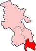
The district was abolished on 1 April 1974. It was partitioned between Windsor and Maidenhead in Berkshire (Datchet, Horton and Wraysbury parishes) and Beaconsfield district in Buckinghamshire, with a small part of Burnham and Wexham parishes going to Slough.

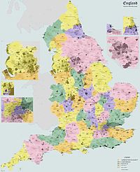
Administrative map of England in 1931.
South Bucks District | ||
|---|---|---|
| Towns (component areas and hamlets) |
|  |
| Other civil parishes (component villages and hamlets) |
| |
| Former districts and boroughs | ||
| Former constituencies | ||
| Ancient boroughs | |
|---|---|
| Incorporated boroughs | |
| Urban districts | |
| Rural districts | |
| Civil parishes | |
Categories:
- History of Buckinghamshire
- Districts of England created by the Local Government Act 1894
- Districts of England abolished by the Local Government Act 1972
- Government and politics of Slough
- Local government in Buckinghamshire
- Rural districts of England