Eureka, Michigan
Eureka, Michigan | |
|---|---|
 Intersection of Maple Rapids and Welling Road | |
 Eureka Location within the state of Michigan | |
| Coordinates: 43°06′13″N 84°30′50″W / 43.10361°N 84.51389°WCoordinates: 43°06′13″N 84°30′50″W / 43.10361°N 84.51389°W | |
| Country | United States |
| State | Michigan |
| County | Clinton |
| Township | Greenbush |
| Settled | 1836 |
| Elevation | 725 ft (221 m) |
| Time zone | UTC-5 (Eastern (EST)) |
| • Summer (DST) | UTC-4 (EDT) |
| ZIP code(s) | |
| Area code(s) | 989 |
| GNIS feature ID | 625657[1] |


Eureka (/jɜːriːkʌ/ yer-REE-kuh) is an unincorporated community and census-designated place (CDP) in Clinton County in the U.S. state of Michigan.[1] The community is located within Greenbush Township. As an unincorporated community, Eureka has no legal autonomy of its own but does have its own post office with the 48833 ZIP Code.[2][3]
Geography[]
Eureka is located in northeastern Greenbush Township in Clinton County. It is centrally located in the state's Lower Peninsula about 30 miles (48 km) north of Lansing and 40 miles (64 km) south of Mount Pleasant.[4]
U.S. Route 127 runs south–north about 3.0 miles (4.8 km) west of the community and is accessible via Maple Rapids Road. Other nearby communities include the village of Maple Rapids to the west, the village of Elsie to the east, the village of Ashley to the north, and the cities of Ovid and St. Johns to the south. Halterman Creek flows through the community.[5]
Eureka is served by St. Johns Public Schools. Eureka Elementary School is located within the community.[6][7] The community has its own post office using the 48833 ZIP Code, although this post office is primarily used for post office box services.[2][3] The St. Johns 48879 ZIP Code also serves the community.[8] Areas to the east of Welling Road may use the Elsie 48831 ZIP Code.[9]
History[]
The area was first settled in 1836 by John Ferdon. The new settlement was first known as Williamsport after early settler Clark Williams. The community was soon known as Barrington for another settler J. A. Barrington. Again, the community's name was known as Swizzletown. The community received its first post office under the name Greenbush on January 29, 1844, which was named after the township. On May 9, 1867, the post office and community were renamed Eureka, which was the name given by Edward Stark using the word eureka "as a place where he had found and others would find a fine place for doing business."[10]
The post office was discontinued on June 29, 1935. It was ultimately reestablished on September 6, 1949. The post office remains in operation and is located at 7907 North Welling Road in the center of the community.[11][12]
The Eureka Cemetery is located on Hyde Road just south of the center of the community.[13] The cemetery remains active, and its oldest gravesite dates back to 1839.[14]
For the 2020 census, Eureka was included as a newly-listed census-designated place, which is included for statistical purposes only. Eureka continues to remain an unincorporated community with no legal autonomy of its own.[15][16]
Demographics[]
This section needs expansion. You can help by . (August 2021) |
Notable people[]
- LaRue Kirby, professional baseball player, born in Eureka[17]
Images[]

Evangelical Church in Eureka (1910) 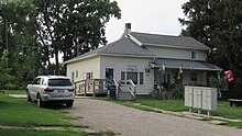
U.S. Post Office in Eureka 
Signage along N. Welling Road


References[]
- ^ a b U.S. Geological Survey Geographic Names Information System: Eureka, Michigan
- ^ a b Google (August 24, 2021). "48833 ZIP Code map" (Map). Google Maps. Google. Retrieved August 24, 2021.
- ^ a b UnitedStatesZipCodes.org (2021). "ZIP Code 48833: Eureka". Retrieved August 24, 2021.
- ^ Michigan Economic Development Corporation (2021). "Greater Lansing Convention & Visitors Bureau: Eureka". Retrieved August 28, 2021.
- ^ U.S. Geological Survey Geographic Names Information System: Halterman Creek
- ^ Michigan Geographic Framework (15 November 2013). "Clinton County School Districts" (PDF). Retrieved August 14, 2021.
- ^ U.S. Geological Survey Geographic Names Information System: Eureka School
- ^ Google (August 24, 2021). "48879 ZIP Code map" (Map). Google Maps. Google. Retrieved August 24, 2021.
- ^ Google (August 24, 2021). "48831 ZIP Code map" (Map). Google Maps. Google. Retrieved August 24, 2021.
- ^ Romig, Walter (October 1, 1986) [1973]. Michigan Place Names: The History of the Founding and the Naming of More Than Five Thousand Past and Present Michigan Communities. Great Lakes Books Series (Paperback). Detroit, Michigan: Wayne State University Press. p. 187. ISBN 978-0-8143-1838-6.
- ^ U.S. Geological Survey Geographic Names Information System: Eureka Post Office
- ^ United States Postal Service (2021). "Eureka – Post Office". Retrieved August 22, 2021.
- ^ U.S. Geological Survey Geographic Names Information System: Eureka Cemetery
- ^ Find a Grave (2021). "Eureka Cemetery". Find a Grave. Retrieved August 21, 2021.
- ^ U.S. Census Bureau (2020). "State of Michigan Census Designated Places". Retrieved July 9, 2021.
- ^ U.S. Geological Survey Geographic Names Information System: Eureka Census Designated Place
- ^ Baseball Reference (2021). "Baseball Reference: LaRue Kirby". Retrieved August 27, 2021.
Municipalities and communities of Clinton County, Michigan, United States | ||
|---|---|---|
| Cities |  | |
| Villages | ||
| Charter townships | ||
| Civil townships | ||
| CDPs | ||
| Other communities |
| |
| Footnotes | ‡This populated place also has portions in an adjacent county or counties | |
| ||
- Census-designated places in Michigan
- Census-designated places in Clinton County, Michigan
- Unincorporated communities in Clinton County, Michigan
- Unincorporated communities in Michigan
- Populated places established in 1836
- 1836 establishments in Michigan Territory