Evans Bay, New Zealand

Evans Bay, located in Wellington Harbour, New Zealand, between the Miramar Peninsula and Hataitai, was the site of New Zealand's first patent slip and served as Wellington's international flying-boat terminal from 1938 until 1956. It is named after George Samuel Evans, an early Wellington settler.[1]
Geography[]

Evans Bay is a large U-shaped bay within Wellington Harbour. Within the bay are smaller features such as Balaena Bay, Hataitai Beach and Shelly Bay. Prior to the Haowhenua earthquake in about 1460 AD, Miramar was an island and Evans Bay would have been open to Lyall Bay.[2][3] Today it is bounded by the Miramar peninsula to the east, the Rongotai isthmus to the south, and a hilly ridge forming part of Hataitai to the west. Formerly the Waipapa Stream flowed from the valley in Hataitai into the head of Evans Bay near the bluff at Wellington Road, creating a large swampy delta.[4][5] This shoreline of the bay in this area was known by Māori as Te Akau-tangi ("the crying shore", or "the murmuring shore").[4] Another Māori name suggested for Evans Bay is Kokotahi te Taniwha.[1]
Considerable reclamation has been undertaken at the southern end of the bay.[6] Kilbirnie Park and Cobham Drive sit on reclaimed land.
Evans Bay as an unofficial Wellington suburb nestles at the western side of the bay between Hataitai, Kilbirnie and Rongotai. Evans Bay Intermediate School takes its name from the general area.
History[]
Patent slip[]
With the increase of steamships on international routes from the mid-nineteenth century, Wellington Chamber of Commerce believed that mail liners would visit Wellington if the city had slipway facilities. In 1866 a British firm named Kennards sent hundreds of tonnes of machinery to Evans Bay but there was a dispute and the equipment sat there for five years until locals backed by British investors formed the Wellington Patent Slip Company (WPSCo). Construction began in 1871 and was completed in May 1873.[7] [8]
The Evans Bay Patent Slip, the first in New Zealand, was a great engineering feat. A 200-ton, 180 foot (54.9 metres) long cradle ran on wheels along a set of rails. Two chains were used for hauling vessels out of the water and lowering them back down. The chains worked on a cogwheel winch which was powered by two steam engines. Construction above the high tide mark was straightforward, but work underwater was far more difficult, requiring accurate work by divers in diving bells who could only work in good weather conditions. This was the first large-scale underwater construction in New Zealand.[9] A 500 foot (154.2 metre) jetty was also erected to improve communication with ships. Along with the winch houses and boiler rooms associated with the slipways were houses, a store, inspector’s office and carpenter’s shop, a messroom and a blacksmith’s shop.[9]
On 2 May 1873 the 316-ton barque Cyprus was the first ship to use the slipway.[7] Ships of 2000 tons or more could be winched up the slip, but without the expected big Panama liners, most ships were smaller and less profitable. In 1908 Wellington Harbour Board purchased the assets of the Wellington Patent Slip Company and leased the operation to the Union Steam Ship Company, with conditions that a second slip be built. This was constructed in 1922.[8][7] In 1961 the Union Steamship Company decided not to renew its lease. The Harbour Board took over running both slips until 1969, when slipway No. 1 was taken out of service and slipway No. 2 was upgraded. The slipway finally closed on 31 July 1980.[8] The site was demolished and various equipment scrapped, sold or given to museums, and land was filled in for a new housing subdivision.[8] In 2003 Wellington City Council applied to rezone the site as a heritage area, and the area is now known as Cog Park.[7][9]
Power station[]
In the early 1920s a coal-fired power station was built at Shag Point in Evans Bay (approximately near the roundabout at the intersection of Calabar Road and Cobham Drive). It began full operation in May 1924[10] and was shut down in 1968.[11] Coke breeze ( a coal by-product) from the power station was used as infill for reclamation at the Evans Bay Yacht Club site.[12] While the power station was unpopular due to its unsightliness and emissions,[11] its outlet pipes discharged warm water into Evans Bay which was enjoyed by bathers.[13][14]
Flying boats[]
Evans Bay functioned as the preferred flying-boat alighting area in Wellington Harbour during the 1930s, and local officials promoted it through the decade as such.[15] However a 1938 report concluded that although Evans Bay was the best site for flying boats in Wellington Harbour, it was subject to strong winds that would make a regular service unviable.[16] Visits from Imperial Airways aircraft took place in 1938 as well as from Pan American types. In 1940 Tasman Empire Airways Limited (TEAL) flew one of their two Short Empire flying boats to Evans Bay with dignitaries who attended the nearby New Zealand Centennial Exhibition located at Rongotai.[17]
Although RNZAF Short Sunderland and Consolidated Catalina flying-boat operations flew intermittently through the 1940s from their seaplane base at Shelly Bay located on the western side of the Miramar Peninsula, it was not until 1950 that TEAL (the forerunner to the national airline Air New Zealand), operated a permanent overseas service to Australia from Evans Bay.[18][19]
A temporary terminal was provided by using roadside parking-garages along Evans Bay Parade at the sheltered western end of the bay next to the patent slip, until a more substantial terminal facility was constructed for TEAL on reclaimed land in 1951.[20] TEAL installed a "Braby" pontoon dock to allow easier boarding and light maintenance of the Short Solent flying boats that TEAL used at the time. Evans Bay could become quite rough in unfavourable weather-conditions and at least one Solent was damaged during alighting, needing substantial repairs.[21][22]
Services to the Chatham Islands also operated from Evans Bay, using aircraft from TEAL and Ansett Airways as well as the RNZAF. A proposal for a peak-time domestic service to Auckland by National Airways Corporation in 1949 using Short Sandringham flying boats to make up for the 1947 closure of Rongotai Airport was turned down[by whom?] as uneconomic compared to DC-3 operations 56 kilometres (35 mi) away at the present-day Kapiti Coast airport.
Nearby Rongotai airfield provided air-traffic control for the alighting area. As advances in aviation overtook the flying-boat concept, TEAL switched to operations and the Evans Bay terminal closed in 1956. Also at the time, Rongotai airfield started undergoing total redevelopment into today's Wellington International Airport, which opened in 1959. An original concept involved developing a joint landbase and flying-boat airport, but this did not come to fruition.[23]
Amenities and points of interest[]
Evans Bay Yacht and Motor Boat Club has premises next to the marina on the western side of the bay, including a hall that can be hired by the public. The club was founded in 1919.[24]
Evans Bay Marina is situated at the southern end of Evans Bay. It has four piers with walk-on access to 141 berths for boats between 6 and 20m long.[25] The marina is managed by Wellington City Council.[26] Wellington Volunteer Coastguard operates from a base at the marina.[27]
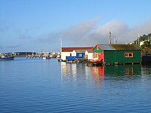
Boat sheds
Fifteen boatsheds are located on the western side of the bay between Hataitai Beach and the Evans Bay Yacht and Motor Boat club. A larger shed purpose-built for the Britannia Sea Scouts has a lean-to on each side of the main shed. The sheds sit above the water on wooden or concrete piles. They were built to store small boats and equipment, probably between the mid-1920s and the early 1930s. Another group of nine boatsheds were demolished to make way for the Evans Bay Marina around the 1950s.[28] The boatsheds are privately owned, with tenure through a coastal permit for a licence to occupy issued by the Greater Wellington Regional Council.[29]
Miramar Wharf and Burnham Wharf
Miramar Wharf and Burnham Wharf are situated on the Miramar peninsula at the eastern head of Evans Bay. Miramar Wharf was funded by the Crawford family and built in 1901.[28] In 1909–1910 the wharf was altered and extended and at the same time a concrete seawall was built to the south and land reclaimed behind it.[30][31] Tram tracks were laid from the wharf through the newly-created cutting to the Miramar Gas Works so that coal could be unloaded more efficiently.[28] The wharf was further lengthened in 1921. In November 2015 the wharf, then owned by Centreport, was closed due to deterioration of the piles.[32] Burnham Wharf was built for the British Imperial Oil Company and opened in 1927.[33] As of 2021 the wharf is operated by Centreport. Aviation fuel for Wellington Airport arrives via Burnham Wharf.[34]
References[]
- ^ a b Reed, A. W. (2002). The Reed Dictionary of New Zealand Place Names. Auckland, New Zealand: Reed. p. 138. ISBN 0 7900 0761 4.
- ^ Homer, Lloyd; Taonga, New Zealand Ministry for Culture and Heritage Te Manatu. "Wellington Harbour before the Haowhenua earthquake". teara.govt.nz. Retrieved 2021-07-22.
- ^ "Event Timeline - Pre 1900". EQC Earthquake Commission. 2015-01-20. Retrieved 2021-07-22.
- ^ a b Adkin, G. Leslie (1959). The Great Harbour of Tara. Wellington, New Zealand: Whitcombe and Tombs Ltd. pp. 11, 96.
- ^ "Lost". New Zealand Gazette and Wellington Spectator. 24 July 1841. Retrieved 25 July 2021 – via Paperspast.
- ^ "Then and now: How Wellington has changed since 1936". Stuff. 2015-01-22. Retrieved 2021-07-22.
- ^ a b c d "Evans Bay Patent Slip". nzhistory.govt.nz. Retrieved 2021-07-22.
- ^ a b c d "Evans Bay Patent Slip Area - Wellington Heritage - Absolutely Positively Wellington City Council Me Heke Ki Poneke". www.wellingtoncityheritage.org.nz. Retrieved 2021-07-22.
- ^ a b c "Evans Bay Patent Slip (Former) | Heritage New Zealand". www.heritage.org.nz. Retrieved 2021-07-22.
{{cite web}}: CS1 maint: url-status (link) - ^ "New Power House: Its Work Begins". New Zealand Times. 19 May 1924. Retrieved 23 July 2021 – via Paperspast.
- ^ a b "Evans Bay Power Station | Engineering New Zealand". www.engineeringnz.org. Retrieved 2021-07-23.
- ^ "The Club | Evans Bay Yacht And Motor Boat Club". EBYMBC. Retrieved 2021-07-23.
- ^ "Wellington Report 2019: Letters on the past, present and future from three residents in the region". Stuff. 2019-10-04. Retrieved 2021-07-23.
- ^ "Tepid Sea Baths". Evening Post. 11 Feb 1928. Retrieved 23 July 2021 – via Paperspast.
- ^ "Board's Keen Interest". Evening Post. 20 Jan 1936. Retrieved 25 July 2021 – via Paperspast.
- ^ "Against Wellington: Verdict on Flying Boat Base". Evening Post. Retrieved 22 July 2021 – via Paperspast.
- ^ Te Papa Museum of New Zealand|Wellington
- ^ "New Air Service: Wellington to Sydney". Otago Daily Times. 19 Aug 1950. Retrieved 22 July 2021 – via Paperspast.
- ^ "Value of Service: Trans-Tasman Air Base at Wellington". Otago Daily Times. 11 Oct 1950. Retrieved 22 Jul 2021 – via Paperspast.
- ^ "TEAL at Evans Bay in Wellington | Wings Over New Zealand". rnzaf.proboards.com. Retrieved 2021-08-10.
- ^ History of Air New Zealand, First Fifty Years, pub 1990
- ^ "Flying Boat Damaged". Otago Daily Times. 18 Oct 1950. Retrieved 22 Jul 2021 – via Paperspast.
- ^ Wings over New Zealand|History of Evans Bay terminal
- ^ "Home | Evans Bay Yacht And Motor Boat Club". EBYMBC. Retrieved 2021-07-26.
- ^ "Evans Bay Marina". Wellington City Council. 2021-07-07. Retrieved 2021-07-26.
- ^ "Marina office and services". Wellington City Council. 2016-08-09. Retrieved 2021-07-26.
- ^ "Our History | Coastguard New Zealand". www.coastguard.nz. Retrieved 2021-07-26.
- ^ a b c Cochran & Murray Conservation Architects (31 Oct 2014). "Coastal Historic Heritage of the Wellington Region" (PDF). Greater Wellington Regional Council. pp. 274–279. Retrieved 26 July 2021.
{{cite web}}: CS1 maint: url-status (link) - ^ "A historic and picture-postcard Wellington boat shed is for sale". Stuff. 2019-10-31. Retrieved 2021-07-26.
- ^ "Harbour Works". Dominion. 17 Jun 1910. Retrieved 10 Aug 2021 – via Paperspast.
- ^ "Inmagic DB/Text WebPublisher PRO: 1 records". www.aucklandcity.govt.nz. Retrieved 2021-08-10.
- ^ "Miramar residents fear for future of Miramar Wharf after its closure last year". Stuff. 2016-10-18. Retrieved 2021-08-10.
- ^ "The Oil Age". Evening Post. 26 Jan 1926. Retrieved 10 Aug 2021 – via Paperspast.
- ^ "Centreport Annual Review 2018-2019 - Ferries & Fuel". 2019annualreport.centreport.co.nz. Retrieved 2021-08-10.
Coordinates: 41°18′40″S 174°48′20″E / 41.31111°S 174.80556°E

- Transport in Wellington
- Geography of the Wellington Region
- Suburbs of Wellington City
- Airports in New Zealand