Exploits River
| Exploits River | |
|---|---|
 | |
| Location | |
| Country | Canada |
| Province | Newfoundland and Labrador |
| Physical characteristics | |
| Source | |
| • location | Red Indian Lake, Newfoundland and Labrador |
| Mouth | |
• location | Bay of Exploits, Newfoundland and Labrador |
• elevation | 0 m (0 ft) |
| Length | 246 km (153 mi) |
| Basin size | 11,000 km2 (4,200 sq mi) |

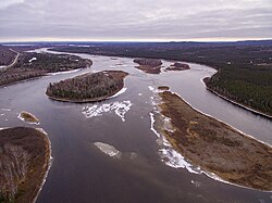
The Exploits River is a river in the province of Newfoundland and Labrador, Canada. It flows through the Exploits Valley in the central part of Newfoundland.
Including the Lloyds River, which discharges in Red Indian Lake, the Exploits river has a length of 246 km, making it the longest river on the island draining an area of 1,100 km2[1] and is the second longest in the province after the Churchill River.
The river drains Red Indian Lake at its starting point and discharges into the Bay of Exploits near the port town of Botwood.
The Exploits River provides habitat for spawning Atlantic Salmon and other species of fish. The salmon population increased dramatically when fish ladders were installed, opening up sections of the river that had been previously inaccessible.
Tributaries[]
- Lloyds River
- Victoria River
See also[]
References[]
- ^ "Atlas of Canada - Rivers". Natural Resources Canada. 2004-10-26. Archived from the original on 2007-02-02. Retrieved 2007-04-19.
Coordinates: 49°04′52″N 55°19′39″W / 49.08111°N 55.32750°W

- Rivers of Newfoundland and Labrador
- Canada river stubs
- Newfoundland and Labrador geography stubs