Bregenz Forest
| Bregenz Forest | |
|---|---|
| Bregenzerwald | |
 Damülser Mittagspitze, 2,095m | |
| Highest point | |
| Peak | Glatthorn |
| Elevation | 2,134 m (7,001 ft) |
| Coordinates | 47°15′56″N 9°52′48″E / 47.26556°N 9.88000°ECoordinates: 47°15′56″N 9°52′48″E / 47.26556°N 9.88000°E |
| Geography | |
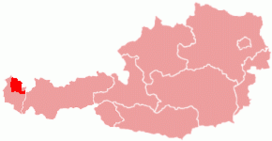 Bregenzerwald region within Austria
| |
| Country | Austria |
| States | Vorarlberg |
| Parent range | Northern Limestone Alps |

The Bregenz Forest (German: Bregenzerwald, pronounced [ˈbʁeːɡɛnt͡sɐˌvalt] (![]() listen)) is one of the main regions in the state of Vorarlberg (Austria). It overlaps, but is not coterminous with, the Bregenz Forest Mountains, which belong to a range of the Northern Limestone Alps, specifically the northern flysch zone. It is the drainage basin of the Bregenzer Ach river.
listen)) is one of the main regions in the state of Vorarlberg (Austria). It overlaps, but is not coterminous with, the Bregenz Forest Mountains, which belong to a range of the Northern Limestone Alps, specifically the northern flysch zone. It is the drainage basin of the Bregenzer Ach river.
Geography[]
The regional inhabitants often divide the Bregenz Forest into two main areas, the Vorderwald ("anterior forest") and Hinterwald ("hinterforest"). The Vorderwald, with its hills and low mountains, is closest to the Rhine valley. The Hinterwald has the higher mountains, with altitudes of up to 2,000 metres. Each of the two regions has its own distinctive dialect variations.
Villages[]

The principal villages in the Bregenz Forest are Bezau (the local capital), Alberschwende, and Egg. Alberschwende, as a historic "Hofsteig" municipality was formerly not part of the Bregenz Forest region.
Lower Bregenz Forest (Vorderer Bregenzerwald) (red)
- Alberschwende
- Doren
- Sulzberg
- Langenegg
- Krumbach
- Riefensberg
- Lingenau
- Hittisau
- Sibratsgfäll
Upper Bregenz Forest (Hinterer Bregenzerwald) (blue)
- Egg
- Andelsbuch
- Schwarzenberg
- Bezau
- Reuthe
- Bizau
- Mellau
- Schnepfau
- Au
- Damüls
- Schoppernau
- Schröcken
- Warth
Culture[]
Dialect[]

Until 1814, parts of the Allgäu in the north and north-west belonged to Vorarlberg. Since the entire region was settled by the Alemanni, the Lake Constance Alemannic dialect became predominant beginning in the 5th and 6th centuries. Over the centuries there was a brisk trading of goods which, with the increased extension of marriages and family networks, led to a linguistic intermingling. Especially in the "Vorderwald" the influence of the Allgäu dialect is particularly noticeable. By contrast, in the Mittelwald and Hinterwald regions the predominant language forms show a stronger connection with the region and Dornbirn. Speakers outside of the Bregenzer Wald region perceive (Wälderisch) as an idiom of its own. It must be noted, however, that there is no uniform Vorarlbergisch dialect - there are considerable local and regional variations. The official language in Vorarlberg is, of course, High German (Hochdeutsch).
Tracht[]
Traditional costumes ("Tracht") have a long history in Vorarlberg. Many valleys and villages have their own kind of garb, each with special characteristics from certain style periods. The Bregenzerwälder garb is the oldest of its kind. It originated in the 15/16th century. The Bregenzerwälder tracht for women is called "" (Bavarian: "Juppe").[1][2] One of the last places that still manufacture the Juppe in the traditional way is the Juppenwerkstatt Riefensberg.[3]
Architecture[]
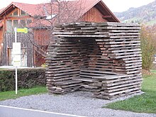
In 2014, the project BUS:STOP Krumbach was completed. When the municipality of Krumbach decided to rebuild seven bus stops in 2010, they hired seven international architects to design bus shelters. Local craftsmen executed their designs. While each stop differs in design, the bus stops are all meant to uniquely integrate architecture into the natural surroundings.[4]
The Werkraum Bregenzerwald is an association of craftsmen in the Bregenz Forest founded in 1999. It aims at networking and supporting craft, design and technology businesses in the area. The publicly accessible place is used to present the craftsmanship, to promote building culture in cooperation with architects and to increase design competence and quality of craftsmanship with the preferred involvement of young people.[5]
Economy[]

Residents of the Bregenz Forest earn their living primarily from tourism, agriculture and especially the wood processing industry. Many locals also commute to work in the Rhine Valley, Vorarlberg's economic center.
Alpine transhumance denotes the three-tier agricultural structure of the Bregenz Forest. It is the seasonal movement of livestock between mountain and lowland pastures, usually under the care of herders. In spring 2011, it was declared as intangible cultural heritage by UNESCO. It was recognised that the Bregenz Forest is "an impressive landscape on the north side of the Alps" that has "largely maintained its traditional farming structure." This includes linear or nucleated villages, with farmsteads dating back to the 18th and 19th centuries. In addition, there are many small craft workshops within the farming communities. Singled out for particular mention were the villages of Thal, Schwarzenberg, and Schoppernau, with their outstanding examples of original Bregenz Forest houses ("Wälderhäuser").[6]
Tourism[]
The Bregenz Forest is known also as a skiing region, but other attractions include the "Käsestraße" and the "Schubertiade" festival of classical music, in Schwarzenberg. The Bregenz Forest is cherished for its unspoiled nature, old traditions, and genuine hospitality. It is also particularly well-known amongst gourmets for its "KäseStrasse Bregenzerwald",[7] an association of farmers, restaurateurs, craftspeople and traders promoting the Bregenz Forest agriculture and its local products, especially cheese. In particular, Bregenz Forest Mountain Cheese ("Bregenzerwälder Bergkäse") and the Alpkäse are internationally renowned specialities.
The Bregenz Forest Railway ("Bregenzerwaldbahn" or, colloquially, "’s Wälderbähnle") is a favorite attraction of the region. It is a museum railway that operates on a surviving section of a narrow gauge railway. From 1902 to 1983, the "Wälderbähnle" worked a line stretching 35.5 kilometres (22 mi) from Bregenz to Bezau. In October 2004, a section of 5 km (3.1 mi) was opened up for tourists again.
In 2000, the Women's Museum opened in Hittisau, the only one of its kind in Austria.[8] The museum is devoted to the display and documentation of the cultural works and (her) stories of women, which deal with a broad variety of topics, including questions of female identity and gender roles.[9]
Another cultural attraction in the Bregenz Forest is the Angelika Kauffmann Museum[10] in Schwarzenberg. The museum is dedicated to the Classicist artist Angelica Kauffman, and has an Austrian museum seal of quality.
The region is also popular because of its hiking and cycling trails.
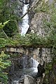
Gallery[]

A typical house in Schwarzenberg

Mother and daughter in Bregenz Forest costume
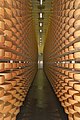
Cheese cellar in Lingenau in the Bregenz Forest

Edelweiss

Snow
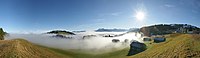
Bödele panorama

Mountain panorama with the dominant Kanisfluh in the centre

Werkraum Bregenzerwald: The "Werkraum Haus" was designed by Peter Zumthor and opened in 2012.


References[]
- ^ "Vorarlberger Landestrachtenverband: Frauentracht". www.trachtenverband.at. Retrieved 2020-09-07.
- ^ "Alles über die Bregenzerwälder Juppe". Trachtenbibel (in de-DE). 2014-09-09. Retrieved 2020-09-07.
{{cite web}}: CS1 maint: unrecognized language (link) - ^ "Juppenwerkstatt Riefensberg". Bregenzerwald in Vorarlberg. Retrieved 2020-09-07.
- ^ "BUS:STOP Krumbach - Everyday Architecture". Urlaub in Vorarlberg (in American English). 2017-08-11. Retrieved 2019-04-26.
- ^ "Werkraum Bregenzerwald – Werkraum" (in de-DE). Retrieved 2021-03-08.
{{cite web}}: CS1 maint: unrecognized language (link) - ^ "Bregenzerwald (Bregenz Forest)" at whc.unesco.org. Accessed on 13 Mar 2013.
- ^ KäseStrasse Bregenzerwald (in German)
- ^ Frauenmuseum Hittisau accessed on 6 September 2011
- ^ Frauenmuseum Hittisau - Konzept (in German)
- ^ Angelika Kauffmann Museum Archived 2018-11-04 at the Wayback Machine accessed on 6 September 2011
External links[]
| Wikimedia Commons has media related to Bregenz Forest. |
- Official website(in English)
Authority control | |
|---|---|
| General |
|
| National libraries | |
- Vorarlberg
- Geography of Vorarlberg
- Regions of Austria
- Bregenz District
- Alemannic German language