Bregenzer Ach
| Bregenzer Ach | |
|---|---|
 | |
| Location | |
| Country | Austria |
| State | Vorarlberg |
| Physical characteristics | |
| Source | |
| • location | Mohnenfluh in the Bregenz Forest Mountains near Schröcken |
| • elevation | 2,400 m (7,900 ft) |
| Mouth | |
• location | Lake Constance at Hard |
• coordinates | 47°30′12″N 9°41′37″E / 47.50333°N 9.69361°ECoordinates: 47°30′12″N 9°41′37″E / 47.50333°N 9.69361°E |
• elevation | 395 m (1,296 ft) |
| Length | 67.0 km (41.6 mi) [1] |
| Basin size | 832 km2 (321 sq mi) [1] |
| Basin features | |
| Progression | Lake Constance→ Rhine→ North Sea |
| Tributaries | |
| • right | Weißach, Subersach |

The Bregenzer Ach (also: Bregenzer Ache) is the main river of the Bregenz Forest, in the Austrian state of Vorarlberg. It is a tributary to Lake Constance, which is drained by the Rhine.
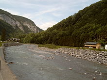
Bregenzer Ache between Mellau and Bezau
References[]
- ^ Jump up to: a b Complete table of the Bavarian Waterbody Register by the Bavarian State Office for the Environment (xls, 10.3 MB)
| Wikimedia Commons has media related to Bregenzer Ache. |
| hide Tributaries of the Rhine | ||
|---|---|---|
| Left (western) |
|  |
| Right (eastern) |
| |
| Authority control |
|---|
This Vorarlberg location article is a stub. You can help Wikipedia by . |
Categories:
- Tributaries of Lake Constance
- Rivers of Vorarlberg
- Bregenzer Ach basin
- Rivers of Austria
- Vorarlberg geography stubs
- Austria river stubs