Lauter (Rhine)
| Lauter | |
|---|---|
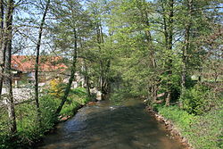 The Lauter between Scheibenhard and Scheibenhardt | |
| Location | |
| Countries | Germany and France |
| Physical characteristics | |
| Source | |
| • location | Palatine Forest |
| Mouth | |
• location | Rhine |
• coordinates | 48°59′6″N 8°16′4″E / 48.98500°N 8.26778°ECoordinates: 48°59′6″N 8°16′4″E / 48.98500°N 8.26778°E |
| Length | 55 km (34 mi) |
| Basin features | |
| Progression | Rhine→ North Sea |

The Lauter (in its upper course also: Wieslauter) is a river in Germany and France.
The Lauter is a left tributary of the Rhine. Its length is 55 kilometres (34 mi), of which 39 km is in France and on the France–Germany border.[1] It is formed by the confluence of two headstreams (Scheidbach and Wartenbach) north of Hinterweidenthal in the Palatine Forest in the German state of Rhineland-Palatinate. It flows through Dahn, crosses the border with France, flows through Wissembourg, and then forms the French-German international boundary until its confluence with the Rhine near Lauterbourg and Neuburg am Rhein.
See also[]
- Lines of Wissembourg
- List of rivers of France
- List of rivers of Rhineland-Palatinate
References[]
External links[]
| hide Tributaries of the Rhine | ||
|---|---|---|
| Left (western) |
|  |
| Right (eastern) |
| |
| Authority control |
|---|
Categories:
- Tributaries of the Rhine
- Rivers of Rhineland-Palatinate
- Rivers of France
- South Palatinate
- Rivers and lakes of the Palatinate Forest
- Rivers of Grand Est
- Rivers of Bas-Rhin
- Rivers of Germany
- France–Germany border
- International rivers of Europe
- Border rivers
- France river stubs
- Germany river stubs
- Rhineland-Palatinate geography stubs