Scheibenhard
Scheibenhard | |
|---|---|
Commune | |
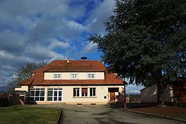 The town hall in Scheibenhard | |
 Coat of arms | |
show Location of Scheibenhard | |
 Scheibenhard | |
| Coordinates: 48°58′47″N 8°08′16″E / 48.9797°N 8.1378°ECoordinates: 48°58′47″N 8°08′16″E / 48.9797°N 8.1378°E | |
| Country | France |
| Region | Grand Est |
| Department | Bas-Rhin |
| Arrondissement | Haguenau-Wissembourg |
| Canton | Wissembourg |
| Government | |
| • Mayor (2020–2026) | Gérard Helffrich |
| Area 1 | 4.62 km2 (1.78 sq mi) |
| Population (Jan. 2018)[1] | 833 |
| • Density | 180/km2 (470/sq mi) |
| Time zone | UTC+01:00 (CET) |
| • Summer (DST) | UTC+02:00 (CEST) |
| INSEE/Postal code | 67443 /67630 |
| Elevation | 115–178 m (377–584 ft) |
| Website | www |
| 1 French Land Register data, which excludes lakes, ponds, glaciers > 1 km2 (0.386 sq mi or 247 acres) and river estuaries. | |


Scheibenhard (French pronunciation: [ʃaibənaʁt][2]) is a commune in the Bas-Rhin department in Grand Est in northeastern France.
It lies on the German border, continuous with the German village of Scheibenhardt, separated only by a small creek, the Lauter.
This creek became the border due to the Vienna Congress of 1815, but from 1870 to 1918 and 1940 till 1945 both sides were annexed by the German Empire/Nazi Germany.
The village is situated near the northeastern corner of France.
See also[]
References[]
- ^ "Populations légales 2018". INSEE. 28 December 2020.
- ^ "Localisation et prononciation des noms de lieux d'Alsace commençant par S". elsasser.free.fr. Retrieved 2021-03-24.
External links[]
| Wikimedia Commons has media related to Scheibenhard. |
| show Authority control |
|---|
This Bas-Rhin geographical article is a stub. You can help Wikipedia by . |
Categories:
- Divided cities
- Communes of Bas-Rhin
- Bas-Rhin geography stubs