Nothalten
show This article may be expanded with text translated from the corresponding article in French. (December 2008) Click [show] for important translation instructions. |
Nothalten | |
|---|---|
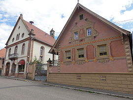 The town hall in Nothalten | |
 Coat of arms | |
show Location of Nothalten | |
 Nothalten | |
| Coordinates: 48°21′10″N 7°25′13″E / 48.3528°N 7.4203°ECoordinates: 48°21′10″N 7°25′13″E / 48.3528°N 7.4203°E | |
| Country | France |
| Region | Grand Est |
| Department | Bas-Rhin |
| Arrondissement | Sélestat-Erstein |
| Canton | Obernai |
| Intercommunality | Pays de Barr |
| Government | |
| • Mayor (2014–2020) | Thierry Allonas |
| Area 1 | 4 km2 (2 sq mi) |
| Population (Jan. 2018)[1] | 456 |
| • Density | 110/km2 (300/sq mi) |
| Time zone | UTC+01:00 (CET) |
| • Summer (DST) | UTC+02:00 (CEST) |
| INSEE/Postal code | 67337 /67680 |
| Elevation | 193–393 m (633–1,289 ft) |
| 1 French Land Register data, which excludes lakes, ponds, glaciers > 1 km2 (0.386 sq mi or 247 acres) and river estuaries. | |


Nothalten is a commune in the Bas-Rhin department in Alsace in north-eastern France.
See also[]
References[]
- ^ "Populations légales 2018". INSEE. 28 December 2020.
| Wikimedia Commons has media related to Nothalten. |
This Bas-Rhin geographical article is a stub. You can help Wikipedia by . |
Categories:
- Communes of Bas-Rhin
- Bas-Rhin geography stubs